
Significantly colder temperatures are setting the stage for the first heavy snow of the 2020 – 2021 winter season, U.S.
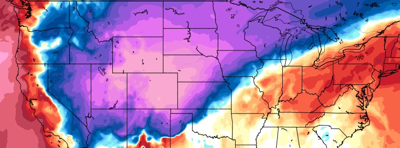
Featured image: 850 hPa Temperature Anomaly valid 00:00 UTC on September 8, 2020. Credit: GFS, TropicalTidbits
Significantly colder temperatures are setting the stage for the first heavy snow of the 2020-2021 "winter" season, NWS Weather Prediction Center reported early September 8, 2020.
- These conditions are caused by a powerful cold front plunging into the south-central Plains, producing a number of hazards, including an early-season snowstorm for the Central Rockies.
- Expect significant accumulations with gusty winds in the higher elevations of Wyoming and Colorado.
- Snow has already been reported across much of Wyoming.
A highly dramatic shift in weather conditions will sweep through the northern to central portions of the country during the next couple of days as the persistent record heat over the western U.S. to the central High Plains will be drastically replaced by a surge of extremely cold air mass from Canada for this time of the year, NWS forecaster Kong noted at 20:00 UTC on September 7.
"The most dramatic changes will transpire during the next 12 hours over the central High Plains where record high temperatures in the 90s to around 100 °F (32 – 38 °C) will plunge all the way to near freezing Tuesday morning behind an 'arctic' cold front," Kong said.
"The Dog Days of Summer this afternoon will literally turn into Old Man Winter Tuesday morning with blustery northerly winds and areas of snow squalls possible from Wyoming down into central Colorado!"
Snow is forecast to accumulate for 150 mm (6 inches) or more at many locations with the highest totals reaching 610 mm (2 feet) possible on the highest elevations.
"Temperatures are forecast to stay in the 30s (-1 to 4 °C) on Tuesday in these areas, which are as cold as 28 °C (50 °F) below normal at the coldest spots," Kong said.
In addition to the cold and snow, a swath of heavy rain can be expected across the upper Midwest north of the sharp front.
The strong dynamics associated with the front will also trigger heavy rain and thunderstorms Tuesday night into Wednesday across western to central Texas.
I'm a dedicated researcher, journalist, and editor at The Watchers. With over 20 years of experience in the media industry, I specialize in hard science news, focusing on extreme weather, seismic and volcanic activity, space weather, and astronomy, including near-Earth objects and planetary defense strategies. You can reach me at teo /at/ watchers.news.
Any weather that kills ticks and mosquitoes can’t be all bad.