
Amphan unexpectedly intensifies into Super Cyclonic Storm — strongest named storm of the 2020 northern hemisphere season
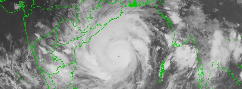
Featured image: Tropical Cyclone "Amphan" at 14:02 UTC on May 18, 2020. Credit: ISRO/RAPID
Tropical Cyclone "Amphan" unexpectedly intensified into a rare Super Cyclonic Storm on May 18, 2020 — becoming the northern hemisphere's strongest tropical cyclone in 2020. This storm can have a high humanitarian impact based on the maximum sustained wind speed, exposed population and vulnerability.
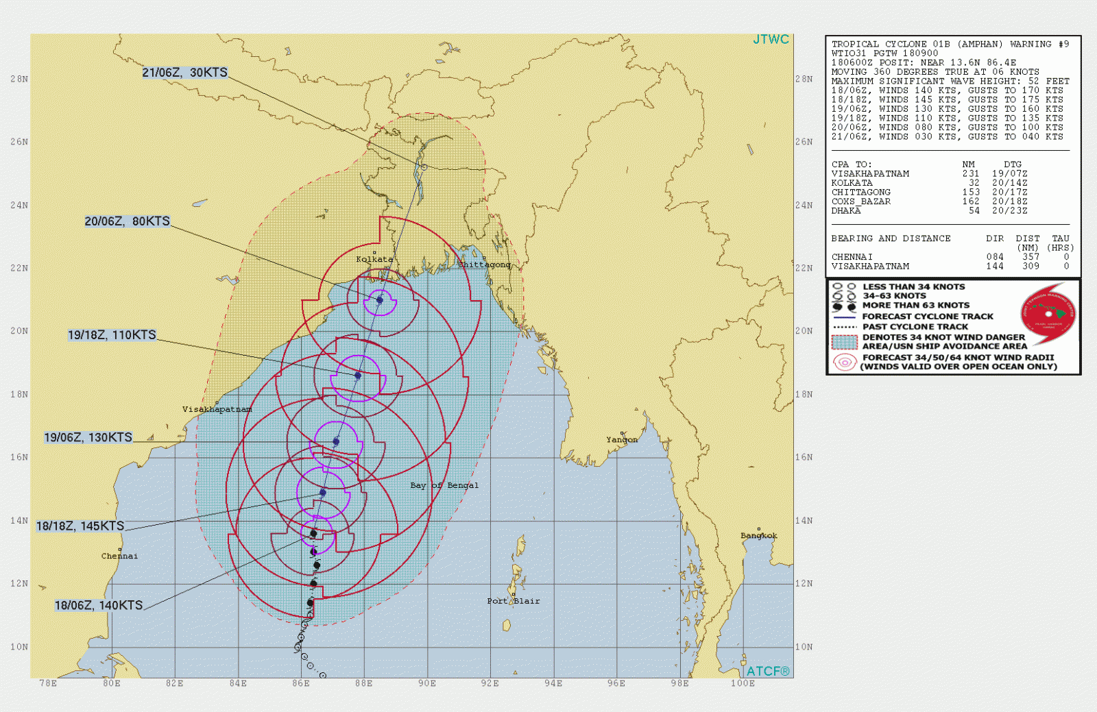
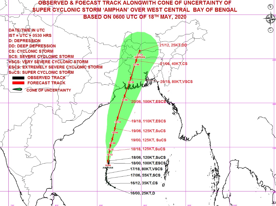
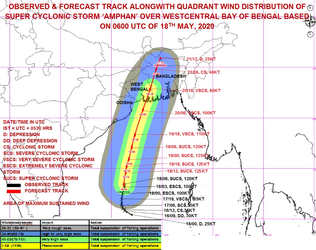
- Landfall is expected from 09:00 and 12:00 UTC on May 20 between Digha, West Bengal, India and Hatiya islands, Bangladesh as an Extremely Severe Cyclonic Storm with maximum sustained surface wind speeds up 175 km/h (110 mph) and gusts to 185 km/h (115 mph).
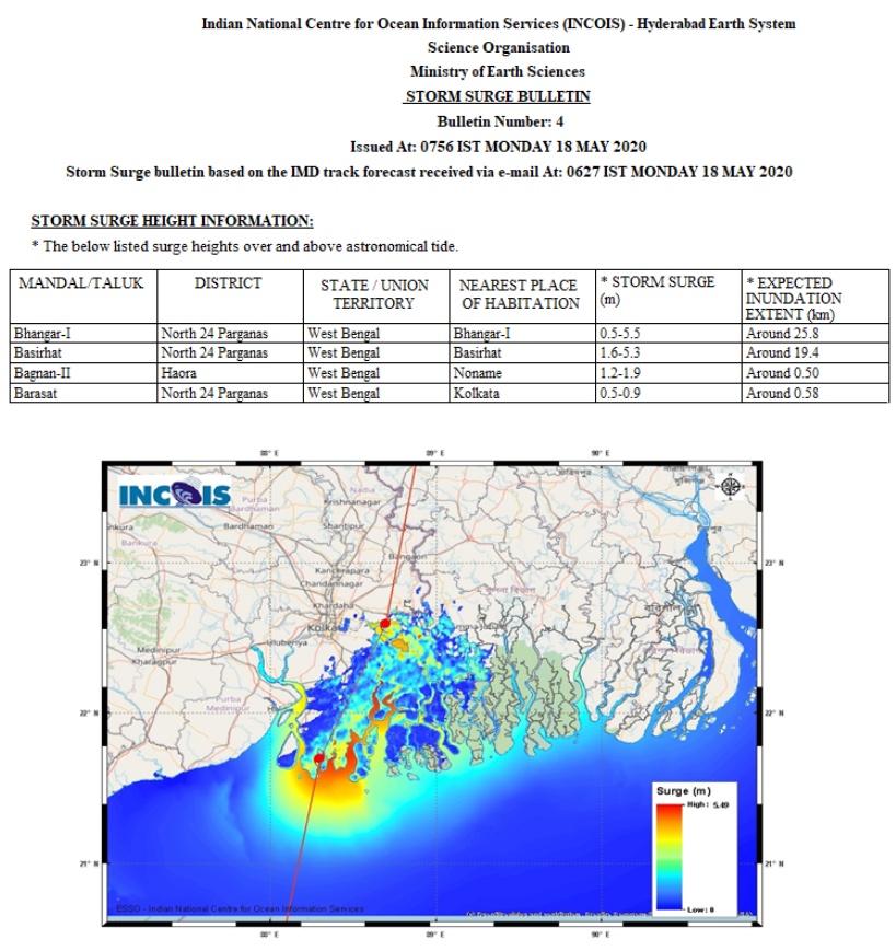
- Catastrophic storm surge — up to 5 m (16 feet) — could hit eastern India and up to 4 m (13 feet) Bangladesh.
- IMD has issued a red alert for heavy rainfall and strong winds in West Bengal.
- The government said it has made arrangements to evacuate 1.1 million people living in vulnerable areas.
Amphan's maximum sustained winds increased from 120 km/h (75 mph) to 260 km/h (160 mph) in just 24 hours to 06:00 UTC on May 18 — Category 5 hurricane equivalent on the Saffir-Simpson scale. This is one of the most extreme rapid intensifications of tropical systems on Earth.
It's likely that Amphan will continue intensifying over the next couple of hours, reaching maximum sustained wind speeds of 270 km/h (170 mph) and gusts to 325 km/h (200 mph) by 18:00 UTC.
As of 09:00 UTC, Super Cyclonic Storm "Amphan" was located about 730 km (450 miles) south of Paradip, Odisha, 890 km (550 miles) SSW of Digha, West Bengal, and 1 010 km (630 miles) SSW of Khepupara, Bangladesh. The system was moving N at 7 km/h (4 mph).
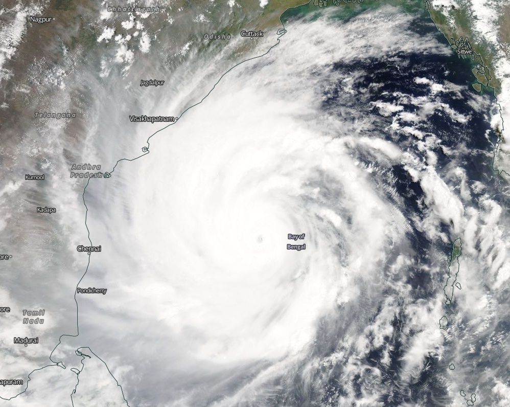
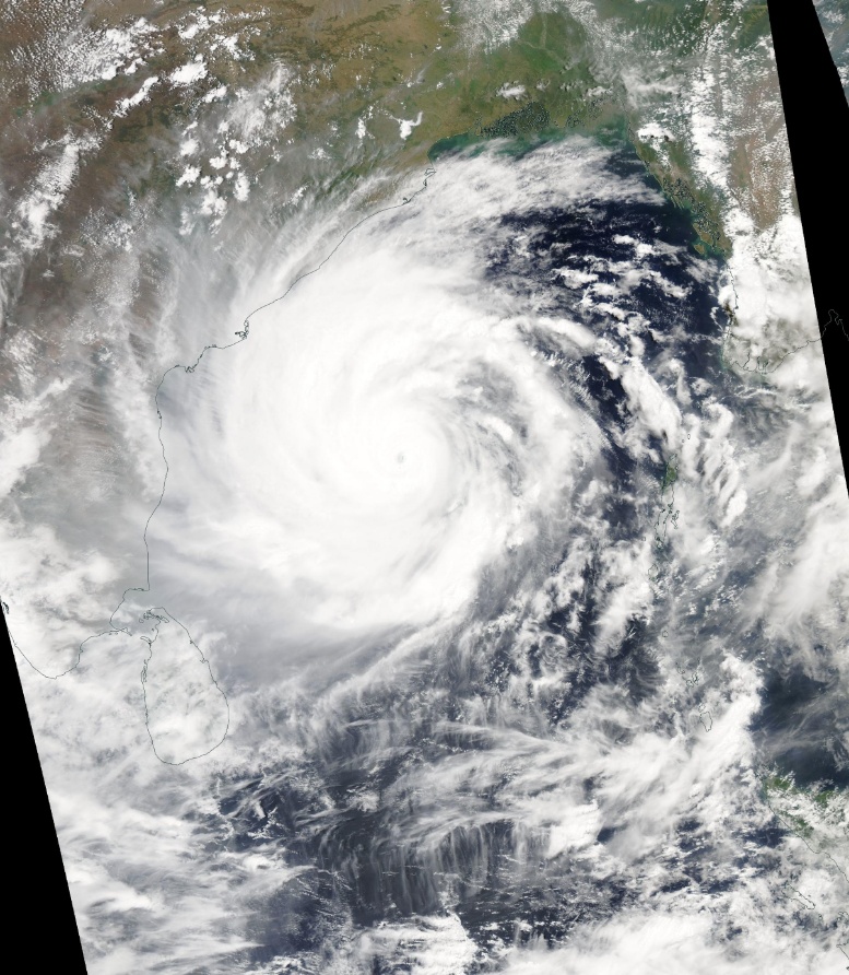
Credits: NASA/Aqua MODIS. Acquired May 18, 2020
The storm is expected to move NNE across the northwest Bay of Bengal and cross the West Bengal and Bangladesh coasts between Digha (India) and Hatiya islands (Bangladesh) between 09:00 and 12:00 UTC on May 20 as an Extremely Severe Cyclonic Storm with maximum sustained surface wind speeds up 175 km/h (110 mph) and gusts to 185 km/h (115 mph).
Coastal Odisha is likely to experience light to moderate rainfall at many places from Monday evening (LT) with heavy rainfall at isolated places over coastal Odisha (Gajapati, Ganjam, Puri, Jagatsinghpur and Kendrapara districts).
Heavy to very heavy rainfall at a few places over north coastal Odisha and isolated heavy rainfall over Khordha and Puri districts are expected on May 19, with isolated heavy rainfall over north Odisha on May 20.
Coastal districts of Gangetic West Bengal are likely to experience light to moderate rainfall at many places with heavy rainfall at isolated places on May 19. Heavy to very heavy rainfall with isolated extremely heavy rainfall is likely over Gangetic West Bengal on May 20 and isolated heavy rain over interior districts of West Bengal on May 21.
Storm surge of about 4 to 5 m (13 – 16 feet) above Astronomical Tide is likely to inundate low lying areas of south and north 24 Parganas and about 3 to 4 m (10 – 13 feet) over the low lying areas of East Medinipur District of West Bengal during the time of landfall.
Damage expected in West Bengal:
- Extensive damage to all types of kutcha houses, with some damage to old badly damaged Pucca structures. Potential threat from flying objects.
- Extensive uprooting of communication and power poles.
- Disruption of rail/road link and several places.
- Extensive damage to standing crops, plantations, orchards.
- Blowing down of Palm and coconut trees.
- Uprooting of large bushy trees.
- Large boats and ships by get torn from their moorings.
Damage expected in Odisha:
- Total destruction of thatched houses/ extensive damage to kutcha houses. Potential threat from flying objects.
- Bending/ uprooting of power and communication poles.
- Major damage to Kutcha and Pucca roads. Minor disruption of railways, overhead power lines, and signaling systems.
- Widespread damage to standing crops, plantations, orchards, falling of green coconuts, and tearing of palm fronds. Blowing down of bushy trees like mango.
- Small boats, country crafts may get detached from moorings.
Fishermen Warning and Action Suggested, West Bengal and Odisha:
- Total suspension of fishing operations from May 18 to 20.
- Diversion or suspension of rail and road traffic.
- People in affected areas remain indoors. Mobilize evacuation from low lying areas.
- Movement in motorboats and small ships not advisable.
I'm a dedicated researcher, journalist, and editor at The Watchers. With over 20 years of experience in the media industry, I specialize in hard science news, focusing on extreme weather, seismic and volcanic activity, space weather, and astronomy, including near-Earth objects and planetary defense strategies. You can reach me at teo /at/ watchers.news.
May we be granted PEACE PEACE PEACE. Gentle wind all over the world in Jesus’ mighty name. Amen
WHEN EARTH’S MAGNETIC FIELD REVERSES ITS POLARITY, STORMS IN THE NORTHERN HEMISPHERE WILL SPIN CLOCKWISE AND THOSE IN THE SOUTHERN HEMISPHERE COUNTERCLOCKWISE?………..WHY THE SO-CALLED TYPHOONS, HURRICANES OR CYCLONES SPIN? AND WHY THEY ALWAYS SPIN COUNTERCLOCKWISE IN THE NORTHERN HEMISPHERE, AND SPIN IN THE OPPOSITE DIRECTION IN THE SOUTHERN HEMISPHERE? …………………..WHY DO THESE STORMS SPIRAL LIKE GALAXIES? IN OTHER WORDS, WHY THESE STORMS RESEMBLE THE SHAPE OF THE SPIRAL GALAXIES? AND WHY THESE STORMS GENERATE GAMMA RAYS LIKE THE GAMMA RAYS THAT ARE DETECTED FROM THE CENTER OF GALAXIES?