
Storms to continue impacting Northwest with cold wave on the way, U.S.
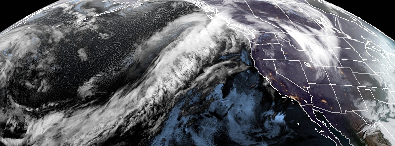
Image credit: NOAA/GOES-West, RAMMB/CIRA. Acquired January 31, 2020, at 11:00 UTC
A series of storms powered by an atmospheric river will continue affecting the Pacific Northwest in the coming days. Winter-like temperatures and snow are also expected to be back on Monday, February 3.
"An extended period of heavy rain is expected for northwestern Oregon and especially western Washington on Friday as an atmospheric river advects copious moisture inland ahead of a cold front," the National Weather Service (NWS) also wrote on their forecast.
Heavy rains ranging from 51 to 102 mm (2 to 4 inches) are likely as the Olympic mountains and Cascades are expected to bear the brunt of the weather.
Snowmelt across existing snowpack may pose threats of flooding, so flood watches are in place for most of western Washington.
Rainfall totals of 2-3 inches are expected in Seattle through the end of the week, and these amounts could be doubled in parts of the Cascades and Olympic Mountains: https://t.co/QdHnRXMJnd pic.twitter.com/6FpSODPFQA
— AccuWeather (@accuweather) January 31, 2020
"Unfortunately, the short-term forecast looks to reinvigorate all of these threats across the Pacific Northwest as a fresh slug of moisture takes aim at Washington and Oregon," AccuWeather said.
"Places like Seattle and Portland will once again have to deal with more rounds of wet weather."
According to Kyle Elliot, the agency's meteorologist, unseasonably warm air will surge into the Northwest throughout the rest of this week.
This storm system is expected to take a more northerly track into the coast, which will result in dry conditions in most of Northern California and Oregon, while Washington and British Columbia will experience wet weather.
As the firehouse of moisture swings back southward into the weekend, colder air will filter in. This will bring snow levels down to more seasonable levels, posing risks of dangerous wintry weather across most of the passes.
Snow and arctic air?! Get prepared for the wintry weather that's on the way. More details, below!https://t.co/IPCHOtZ68d pic.twitter.com/yPfkP5JLSW
— WeatherNation (@WeatherNation) January 31, 2020
By Sunday, February 2, snow levels may decrease to around 610 m (2 000 feet) or lower across the Cascades. Colder air due to a dip in the jet stream is forecast to continue through early next week.
By Tuesday, February 4, the eastern half of the U.S. will see snow and rain as the cold air and moisture follows the front, said Weather Nation.
"Snow totals will be on the higher end. Especially for everyone out west."
Commenting rules and guidelines
We value the thoughts and opinions of our readers and welcome healthy discussions on our website. In order to maintain a respectful and positive community, we ask that all commenters follow these rules.