
Medicane “Trudy” (Detlef, Bernardo) makes landfall in Algeria
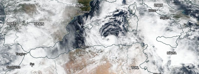
Image credit: NASA/NOAA Suomi NPP/VIIRS
A shallow, warm-core cyclone or medicane informally named Trudy, also Detlef and Bernardo, formed in the western Mediterranean on November 11, 2019, and made landfall in Algeria on the same day.
The storm made landfall with maximum sustained winds of 110 km/h (70 mph) and minimum pressure of 992 hPa close to Beni Belaid, Algeria on November 11.
#medicane #MedicaneTrudy pic.twitter.com/fOvCVGrMUF
— Mediterranean Cyclone Centre (@Medicane_Centre) November 11, 2019
Here are some of the best images of #MedicaneTrudy around peak yesterday. #medicane #weather #hurricane pic.twitter.com/c9wx9I9K9m
— Mediterranean Cyclone Centre (@Medicane_Centre) November 12, 2019
Update 4 on #MedicaneTrudy / #MedicaneDetlef / #StormBernardo
Trudy/Detlef/Bernardo's circulation has been destroyed by mountains in #Algeria, causing its dissipation. Its remnants are going to be absorbed by a second developing cyclone, #CycloneVictoria (named by Greece). pic.twitter.com/dbqz22p9sT
— Mediterranean Cyclone Centre (@Medicane_Centre) November 11, 2019
"Detlef weakened soon after it made landfall," Severe Weather Meteorologists noted. As of 15:00 UTC on November 11, mean sea level pressure analysis showed a small cyclone southwest of Sardinia Island, Italy.
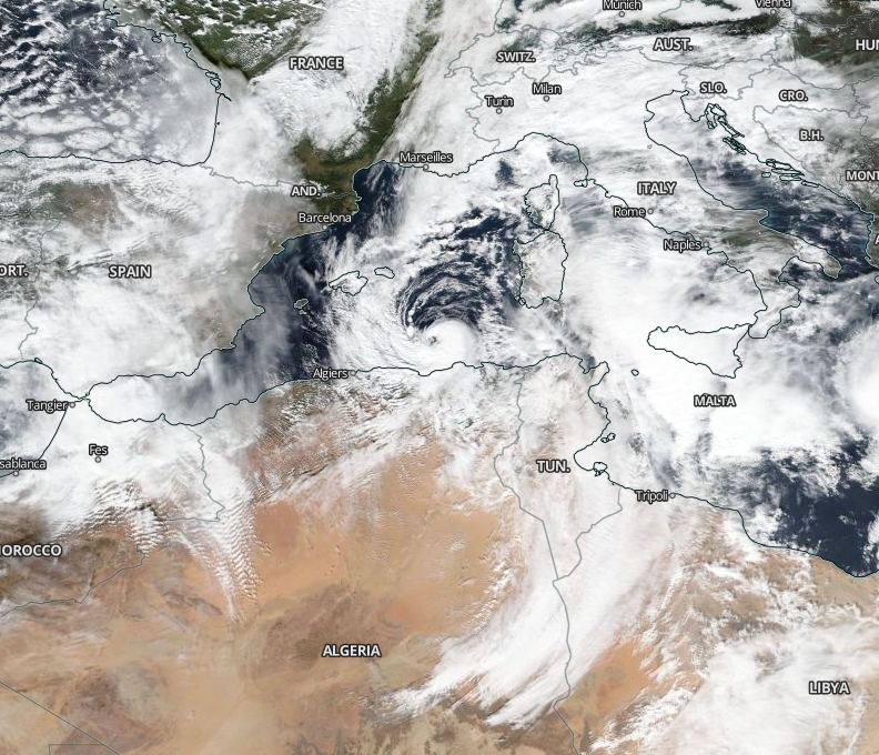
Image credit: NASA/NOAA Suomi NPP/VIIRS
Another quick look at #medicanetrudy in the Western Mediterranean, just off #algeria. #medicane #mediterranean #hurricane #europe pic.twitter.com/G1JFv4aeVf
— Mediterranean Cyclone Centre (@Medicane_Centre) November 11, 2019
The cyclone was a part of the large cyclonic system under a big, deep upper cold-core over the Mediterranean.
Satellite imagery showed a rapidly developing structure with an intense convective band wrapping around an eye. The convective band was wrapping in the core tightly, with highly defined upper-level outflow on the southeast quadrant of the system.
The medicane spawned damaging winds, storm surge, and violent waves.
The system is also responsible for widespread convective storm clusters over south Italy, Malta, and Ionian sea, as well as the cold front moving east-northeast in the afternoon and evening.
Commenting rules and guidelines
We value the thoughts and opinions of our readers and welcome healthy discussions on our website. In order to maintain a respectful and positive community, we ask that all commenters follow these rules.