
Extreme rainfall, major flooding event in Greece
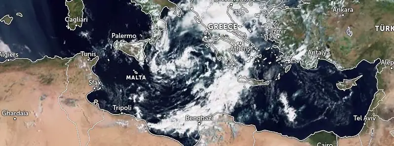
Featured image: Medicane forming in the Mediterranean Sea. Credit: EUMETSAT/Meteosat-10, Zoom Earth, The Watchers. Acquired at 09:45 UTC on September 5, 2023
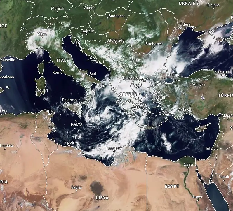
Weather models suggest Greece will continue to be impacted by a major rainfall event over the next two days, raising the threat of major flooding in parts of the country. At the same time, a Mediterranean tropical-like cyclone, known as a medicane, threatens to escalate flooding risks in Sicily, Malta, and Libya.
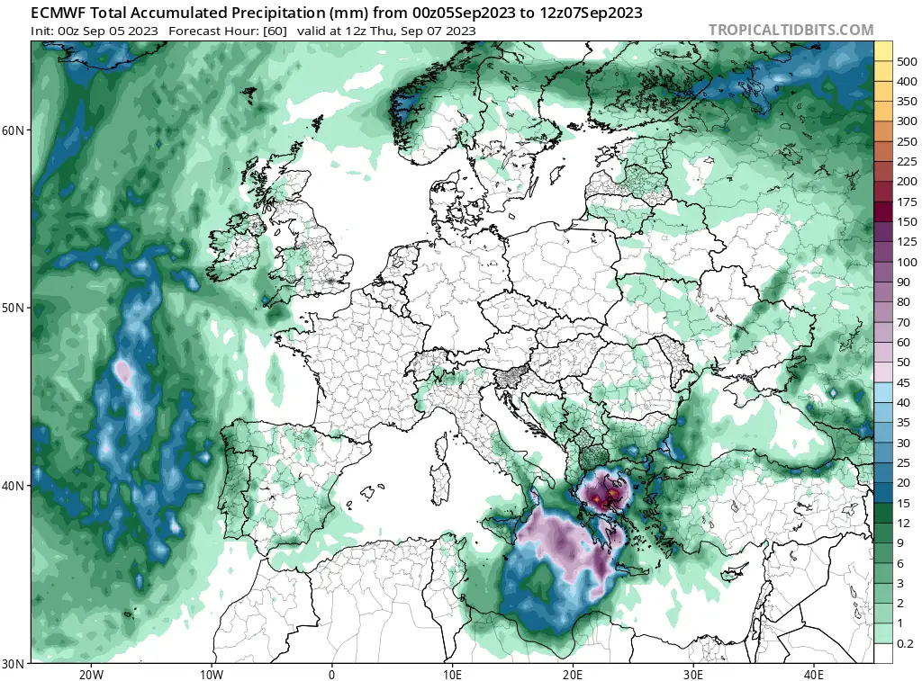
Greece, having recently battled widespread fires fueled by intense heatwaves, is now under the looming threat of a major flooding event. Severe flooding has already been reported in parts of the country, and meteorological predictions foresee more rainfall in the days ahead — between 400 and 600 mm (16 – 24 inches) of rainfall from September 5 to 7.
In certain regions, this could peak at an alarming 1 000 mm (39 inches) or more, according to Marko Korosec of the Severe Weathher Europe. Such precipitation levels portend significant to catastrophic flooding consequences across parts of the nation.
Simultaneously, atmospheric patterns indicate the potential formation of a medicane in the Ionian Sea, a rare tropical-like cyclone event for the Mediterranean. The last similar occurrence was documented towards the end of October 2021, when a medicane formed east of Malta, resulting in significant rainfall over Sicily.
The trajectory and intensity of the emerging subtropical system are yet to be firmly established. However, various meteorological models project the possibility of severe winds and flooding impacts extending to Sicily, Malta, and even Northern Libya. Local communities in these regions are advised to be vigilant as the week progresses.
Weather dynamics indicate that after a medicane system emerges, it will drift across the Ionian Sea, potentially affecting western and southern regions. The evolving weather conditions have notably hinted at the Libyan coast bearing the brunt of the system, especially if a landfall transpires over the weekend or in its vicinity.
The formation of this system has its roots in the sustained marine heatwave across the Mediterranean, persisting into the initial phase of the autumn season of 2023. The anomalous seawater temperatures are a significant contributor. Compounding the regional weather complexities is the Heat Dome over Western Europe, flanked by two deep troughs. One of these troughs has already manifested in extensive flooding in Spain.
As the low-pressure system over Greece migrates southwest into the southern Mediterranean, it’s anticipated to deepen. An air mass convergence between the southern and northern zones will transport high moisture from the Aegean and Black Seas. Consequently, this will trigger a substantial influx of a warm and moist air mass targeting Greece’s higher terrains, precipitating the forecasted extreme rainfall. The consensus among weather models suggests rainfall amounts surpassing 500 mm (20 inches) in the imminent three-day period, with some projections even doubling this estimate.
These meteorological adversities come on the heels of a sweltering summer where Greece grappled with rampant wildfires, some of the most devastating in Europe since the inception of the European Forest Fire Information System (EFFIS) in 2000. Notably, a wildfire originating near Alexandroupolis spread extensively across the Evros region, resulting in numerous fatalities and significant destruction.
The arrival of September brought with it a respite from the scorching temperatures and a much-anticipated onset of cooler weather. However, the impending deluge of rain has now shifted concerns from fire containment to flood preparedness.
From the Mediterranean Cyclone Centre:
In the Outlook issued at 15:00 UTC on September 4, meteorologists from the Mediterranean Cyclone Centre have provided insights on the evolving weather conditions in the region.
“Current conditions are tilting towards favorability for the emergence of a subtropical system. There’s a potential for a medicane to form within a timeframe ranging from 36 to 120 hours. Even if this development does not materialize fully into a medicane, the low-pressure system is anticipated to persist over the central Mediterranean Sea, extending beyond the current forecast period.”
In terms of probabilistic analysis, there’s a low 20% chance for (sub)tropical formation in the next 48 hours. However, this likelihood increases to a medium risk of 50% over the forthcoming 5 days.
References:
1 A potential Medicane is Forecast to form in the Ionian Sea this week, posing a heavy Rainfall threat for Sicily and Malta. Major Flooding Event Expected for Greece – Severe Weather Europe – September 4, 2023
I'm a dedicated researcher, journalist, and editor at The Watchers. With over 20 years of experience in the media industry, I specialize in hard science news, focusing on extreme weather, seismic and volcanic activity, space weather, and astronomy, including near-Earth objects and planetary defense strategies. You can reach me at teo /at/ watchers.news.
Commenting rules and guidelines
We value the thoughts and opinions of our readers and welcome healthy discussions on our website. In order to maintain a respectful and positive community, we ask that all commenters follow these rules.