
Exceptionally heavy rains hit Rio Grande do Sul, causing deadly floods, Brazil
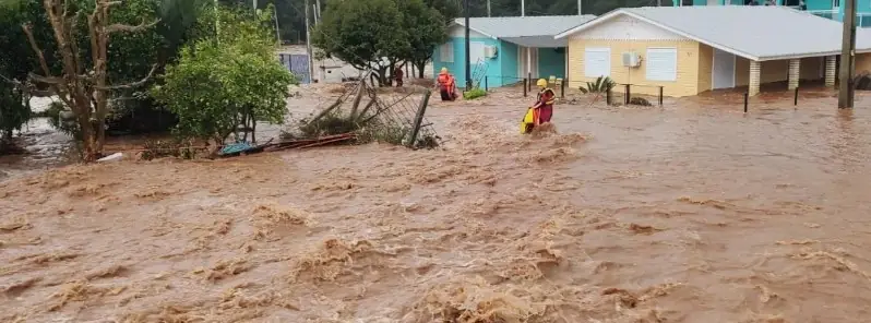
Image credit: City Hall of Nova Basano
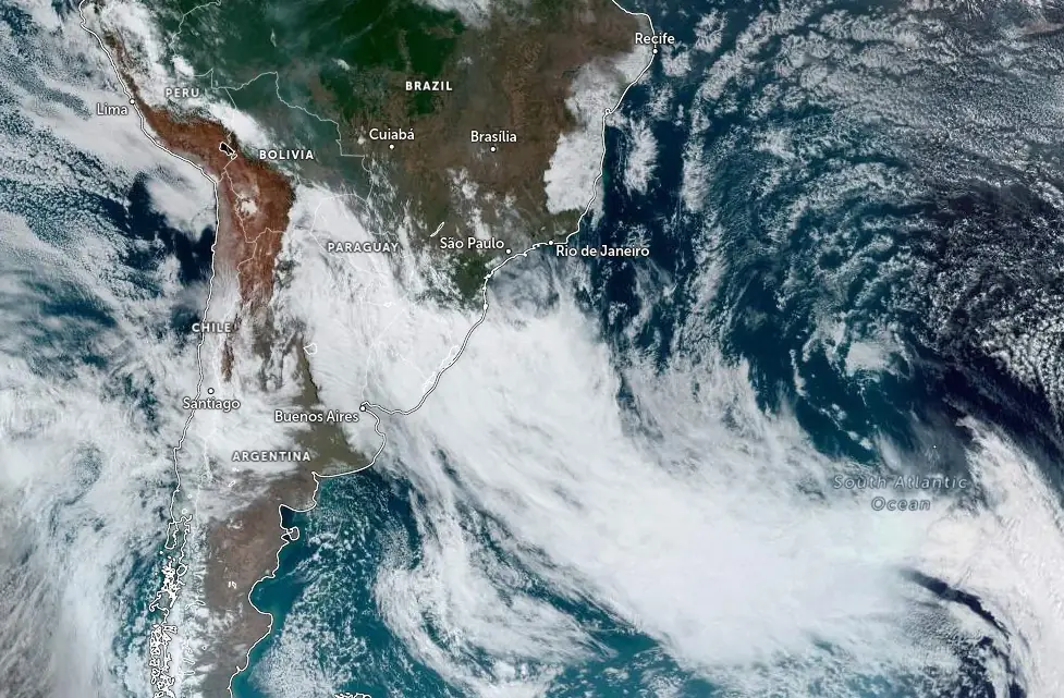
At least four people died Monday, September 4, 2023, after an extratropical cyclone dumped extremely heavy rains that triggered severe floods and landslides in the southernmost Brazilian state of Rio Grande do Sul. Parts of the northern half of the state received 2 and even 3 months’ worth of September rains in just 72 hours.
Between September 3 and the early hours of September 4, the northern half of Rio Grande do Sul experienced intense rainfall, with some areas seeing over 300 mm (11.81 inches) of rain. This is remarkable given that the historical average precipitation for the entire month of September in Passo Fundo, based on data from 1991 to 2020, stands at 165.5 mm (6.52 inches). Essentially, the region witnessed two months’ worth of rainfall in just two days.
Cities spanning from the Center to the Northeast of the state reported rainfalls ranging from 100 mm (3.94 inches) to 250 mm (9.84 inches).
In the span of 72 hours, data from the National Institute of Meteorology show the following accumulations:
- Passo Fundo: 260 mm (10.24 inches)
- Cruz Alta: 249 mm (9.8 inches)
- Serafina Corrêa: 228 mm (8.98 inches)
- São Luiz Gonzaga: 212 mm (8.35 inches)
- Ibirubá: 202 mm (7.95 inches)
- Palmeira das Missões: 181 mm (7.13 inches)
- Vacaria: 169 mm (6.65 inches)
- Santiago: 160 mm (6.3 inches)
- Soledade: 150 mm (5.91 inches)
- Cambará do Sul: 149 mm (5.87 inches)
- Tupanciretã: 139 mm (5.47 inches)
- Lagoa Vermelha: 137 mm (5.39 inches)
- Santo Augusto: 133 mm (5.24 inches)
- Canela: 123 mm (4.84 inches)
- Santa Rosa: 113 mm (4.45 inches)
- Teutônia and São Borja: 111 mm (4.37 inches) each
- São Vicente do Sul: 107 mm (4.21 inches)
- Santa Maria: 102 mm (4.02 inches)
Over the last 24 hours leading up to 09:00 LT on September 4:
- Cruz Alta: 157 mm (6.18 inches)
- Passo Fundo: 154 mm (6.06 inches)
- Vacaria: 147 mm (5.79 inches)
- Cambará do Sul: 144 mm (5.67 inches)
- Serafina Corrêa: 143 mm (5.63 inches)
- Ibirubá: 133 mm (5.24 inches)
- São Luiz Gonzaga: 123 mm (4.84 inches)
- Soledade: 100 mm (3.94 inches)
Additionally, data from the National Center for Monitoring Disasters (Cemaden) show the following values over the period of 72 hours:
- Passo Fundo: 307 mm (12.09 inches)
- Água Santa: 253 mm (9.96 inches)
- Ijuí: 241 mm (9.49 inches)
- Entre-Ijuís: 234 mm (9.21 inches)
- Vacaria: 203 mm (7.99 inches)
- Serafina Corrêa: 167 mm (6.57 inches)
- Santa Maria: 157 mm (6.18 inches)
- Caxias do Sul: 156 mm (6.14 inches)
Historically, this amount of rainfall is extraordinary. For instance, the historical averages for September, based on the 1991-2020 period, in cities like São Luiz Gonzaga and Cruz Alta, are 146.6 mm (5.77 inches) and 162.5 mm (6.40 inches) respectively.
The repercussions of this deluge are evident. Major rivers in Rio Grande do Sul are poised for flooding in the subsequent days, with several smaller rivers in the northern half of the state also bracing for similar outcomes. This has already had tragic implications; four individuals lost their lives in Mato Castelhano, Ibiraiaras, and Passo Fundo. One man faced a tragic end due to electrocution in his flooded home, while another man and a couple perished when their vehicles were swept away by the floodwaters.
Beyond these tragic fatalities, over 15 cities, including the state capital, Porto Alegre, are grappling with the impacts of the flood.
On September 4, MetSul Meteorologia issued an emergency warning for severe flooding in Vale do Taquar, emphasizing the urgency and severity of the situation. The floods, they caution, could be historic in magnitude, with water levels rising rapidly, urging those in risk-prone areas to seek higher ground.
The gravity of the situation was underscored by Deputy Mayor Amarildo Baldasso of Muçum, who labeled the circumstances as ‘chaotic’. Baldasso highlighted the rapid rise of water levels, something unprecedented in the city’s history. He detailed the distressing scene of about 50 families trapped in their homes, streets inundated, and the city plunged into darkness due to power outages.
The capital, Porto Alegre, hasn’t been spared either. Torrential rain has led to a series of disruptions, from falling trees and landslides to residents finding themselves stranded due to flooding.
Historically, September has been a rainier month in the southern parts of Brazil. Yet, the precipitation seen in the early days of September 2023 suggests a month that may be anomalously wet. Some northern cities in Rio Grande do Sul could see rainfall ranging between 500 mm (19.69 inches) to 700 mm (27.56 inches) this month, mirroring the rainfall of an entire spring season or even half of the yearly average.
Weather experts at MetSul had previously forecasted the implications of El Niño, expecting a surge in rainfall towards the end of winter and spring. The recent downpour aligns with their prediction, having previously warned of potential flooding in the latter half of the year. It’s worth noting that just a few months prior, in June, an extratropical cyclone had claimed 16 lives in the state.
🔴 AGORA | Pessoas estão ilhadas no município de Nova Araçá, na região serrana do Norte gaúcho. Inundações tomam conta do município. 📷 Vox FM pic.twitter.com/dHygyMbMEJ
— MetSul Meteorologia (@metsul) September 4, 2023
🔴 TEMPO | Cheia do Rio das Antas leva parte da tradicional ponte de ferro que liga Farroupilha a Nova Roma do Sul. pic.twitter.com/4uuIIY702w
— MetSul Meteorologia (@metsul) September 4, 2023
🔴 URGENTE | Enchente catastrófica atinge agora o município de Roca Sales, no Vale do Taquari. Águas do Rio Taquari invadem rapidamente a área urbana do município. Trata-se de situação de excepcional perigo. Se você está no Vale em áreas alagadiças, busque terreno alto! pic.twitter.com/vhSk1a8rpT
— MetSul Meteorologia (@metsul) September 5, 2023
🔴 AGORA | Município de Muçum (RS) está tomado pelas águas. Há moradores em telhados e pedidos por barcos para resgate pela enchente catastrófica do Rio Taquari. Saiba mais em https://t.co/X2kIQ1S4ek. pic.twitter.com/bZIRMRKRuQ
— MetSul Meteorologia (@metsul) September 5, 2023
MetSul predicts a second episode of heavy rain in the second half of this week, between Thursday and Saturday, September 7 and 9, which should bring the highest accumulated rainfall in the southern and western parts of Rio Grande do Sul, but will also cause heavy rainfall in parts of the north, the hardest hit right now.
References:
1 News and updates posted by MetSul Meteorologia on September 4, 2023
I'm a dedicated researcher, journalist, and editor at The Watchers. With over 20 years of experience in the media industry, I specialize in hard science news, focusing on extreme weather, seismic and volcanic activity, space weather, and astronomy, including near-Earth objects and planetary defense strategies. You can reach me at teo /at/ watchers.news.
Commenting rules and guidelines
We value the thoughts and opinions of our readers and welcome healthy discussions on our website. In order to maintain a respectful and positive community, we ask that all commenters follow these rules.