
Typhoon “Nakri” (Quiel) exits the Philippines, now heading toward Vietnam

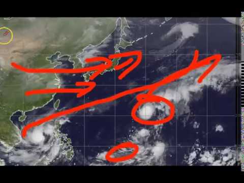
Featured image: Tropical Storm "Nakri" at 12:40 UTC on November 9, 2019. Credit: JMA/Himawari-8, RAMMB/CIRA
Typhoon "Nakri," known as "Quiel" in the Philippines is now exiting the Philippine Area of Responsibility (PAR). The storm is accelerating further westward at 15 km/h (9 mph) towards Vietnam with maximum sustained winds of 120 km/h (74 mph) near the center and gustiness of up to 150 km/h (93 mph), according to PAGASA.
Based on all available data, the eye of Nakri was located at 145 km (90 miles) North of Pagasa Island, Palawan, as of 10:00 LT.
The typhoon had triggered rains in parts of Luzon and Visayas in the past days causing floods, particularly in Cagayan.
The tail-end of a cold front will continue to bring light to moderate with occasional heavy rains tomorrow morning, November 10, over Cagayan, including Babuyan Islands, Isabela, Apayao, Ilocos Norte, and Aurora.
Residents of the said areas, particularly those living in areas considered to be highly or very highly vulnerable to floods and landslides, are advised to take safety and precautionary measures.
Officials also urged people to coordinate with local disaster risk reduction and management offices, as well as continue monitoring for updates especially the thunderstorm or rainfall advisories and heavy rainfall warnings to be issued by PAGASA Regional Services Divisions.
Rough sea conditions are prevailing over the seaboards of Northern Luzon and the western seaboards of Central and Southern Luzon, making sea travel risky especially for small sea vessels.
According to PAGASA's forecast, Nakri will be 290 km (180 miles) Northwest of Pagasa Island by tomorrow morning, November 10, at 12.5°N, 111.9°E.
In 48 hours, the storm is expected to be 55 km (34 miles) West Northwest of Pagasa Island at 13.3°N, 109.6°E.
By Tuesday morning, November 12, Nakri will be 795 km (494 miles) West Northwest of Pagasa Island at 14.6°N, 107.8°E.

According to Weather Philippines, Nakri is expected to make landfall over Eastern Vietnam, north of Nha Trang City by Monday morning, November 11. It will slightly weaken while turning West Northwestward about 1 114 km (692 miles) West Northwest of Puerto Princesa, Palawan, at 95 km/h (59 mph)

Image credit: Joint Typhoon Warning Center (JTWC)

Image credit: JTWC
Meanwhile, another weather system has been tracked over the Western Pacific Ocean. The system dubbed as Tropical Disturbance (LPA) 91W has been moving westward across Western Micronesia and could enter PAR by Monday, November 11.

Image credit: JTWC

Published in the last 24 hours
- In 1954, a grapefruit-sized meteorite crashed through a roof in Sylacauga, Alabama, and struck Ann Hodges as she napped on her couch Epicenter
- A meteorite blew a crater beside a village near Lake Titicaca in 2007, and dozens of villagers who went to see it got headaches and nausea, though tests found nothing the rock had added to the water Epicenter
- The people who pay closest attention to the weather are the ones storms have already cost the most, a study of 946 students found, with one damaging storm making little difference to how much attention a student paid, but two or more making a clear one Epicenter
- The sea is falling in Juneau, Alaska, because land freed from melted glaciers is rising about 0.6 inches a year Epicenter
