
Surge of Arctic air brings record cold temperatures and widespread snow, USA
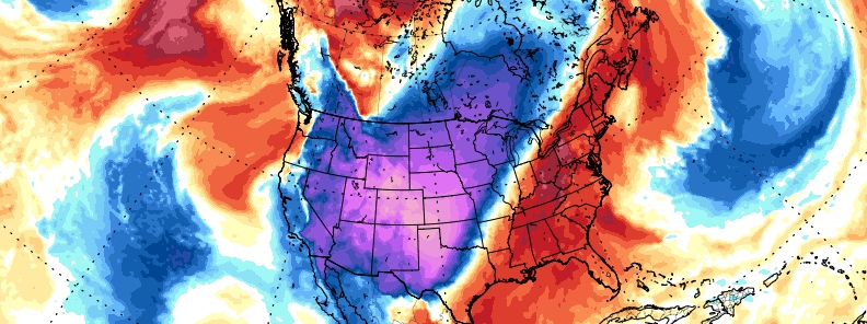
Image credit: GFS, TropicalTidbits
A deep upper-level low over central Canada is bringing the coldest air mass thus far this season down from western Canada into the northern Rockies and into the northern Plains, U.S.
This surge of arctic air is poised to bring heavy snow for the Rockies together with widespread record cold temperatures into much of the interior western U.S., even into the central and southern Plains during the next few days.
Temperatures in Peter Sinks, Utah (elevation 2 400 m / 8 000 feet a.s.l.) dropped to -37.1 °C (-34.7 °F) on October 28, 2019, setting a new national cold record for the month of October. This area is known for its cold winters, with the lowest temperature on record -56 °C (-69 °F) registered on February 1, 1985.
Widespread snow developed across Northeast and north-central Colorado Tuesday morning, October 29, delaying more than 250 flights and canceling 350 at Denver International Airport.
"Due to very cold temperatures, roads will become icy and snow-packed, with hazardous travel conditions, later this morning through tonight. Expect a difficult evening commute along the I-25 and I-70 Corridors and again Wednesday morning," NWS meteorologists warned.
Steadier light snow will continue overnight as well with some moderate snow this evening. Total accumulations will range from 20 – 40 cm (8 to 16 inches) in the mountains and foothills with 15 – 30 cm (6 to 12 inches) over portions of the adjacent plains. Mountain valleys will see 10 – 20 cm (4 to 8 inches).
"The cold air is being funneled southward from Canada into the western and central United States by a southward plunge of the jet stream," TWC meteorologists said. "That dip in the jet stream will slowly migrate eastward late in the week, taking the colder air with it. Not only will it be cold, but accumulating snow is expected from the Rockies to the Plains and upper Midwest."
Another look at the fresh snowfall in Iowa and Wisconsin via Terra #MODIS with false color providing a clearer distinction between clouds and snow where ice (including high clouds) and the new snow cover are shaded cyan. #IAwx #WIwx pic.twitter.com/NEltEPQImZ
— UW-Madison CIMSS (@UWCIMSS) October 29, 2019
Temperatures are forecast to be 14 – 25 °C (25 to 45 °F) below average, with actual readings dipping below zero at the coldest locations over the northern and central Rockies.
The winds will also pick up as the heavy snowfalls, and they could be enhanced by local terrain as an expansive high pressure system builds in from the north. Blowing snow along with wind chills as low as -31.6 °C (-25 °F) below zero could be experienced in these areas. By Wednesday evening, much of the snow should be exiting the central Rockies and moving into the central Plains.
The snow should then reach the upper Midwest Wednesday night where up to 15 cm (6 inches) could accumulate by Thursday morning, October 31. This is in response to the development of a low pressure system over the southern Plains as it moves rapid toward the Mid-Mississippi Valley Wednesday evening and into the Appalachians Wednesday night.
I'm a dedicated researcher, journalist, and editor at The Watchers. With over 20 years of experience in the media industry, I specialize in hard science news, focusing on extreme weather, seismic and volcanic activity, space weather, and astronomy, including near-Earth objects and planetary defense strategies. You can reach me at teo /at/ watchers.news.
Curious about the winter that have will, I’m going to tell me, the winter we will know & I mean not us = (all the earth planet), the winter that we all know this year 2019 -2020 will be the NEVER seen the coldest, (if you have found it quite cold last winter in 2018-2019 was cold and well you see anything), because this year, the cold will be much more extreme than the past year & its going to be getting worse because we are in the biggest solar minimum for a long time & we are entering this year in a new ice age & have already had a taste.
& For those who still believe (IN GLOBAL WARMING) & well I tell you, you have been brainwashed with lies, (journalists, that is say through not say NEVER truth, they not work for good, he works for the enemy, the prince of this world (Satan), journalists are managed by real governments, who works in the shadows, it is the illuminati, the framasons, Jesuit & all other occult movements & sects & Rome, the Roman Catholic church of lot from the beginning). If you think the headliners you see paraded on television, all these people who supposedly shape the governments of each country are the true governments and well I tell you that this is FALSE, they are only to execute them the orders of the real governments that lurks in the shadows.
This world is corrupt to the core & the end of the world the true end, as prophesied in the Torah & the old version of the Holy Bible is being fulfilled at this very moment I am writing this very long message, the third of the Apocalypse & Seal is opened in very little time the 4th Seal will open, which will triggered the pain of childbirth, meaning, explanation: the waters the earth will be released & to start all the cities that are built on islands are the first to disappear and all the places that are low where the sea level, the only place that will not be flooded will be the place that are built up, up above the sea, while the rest will be destroyed, REPENT, REPENT, REPENT, and ask FORGIVENESS at one & only true God, to create the heaven and the earth and all that it contains, it is called YAHUWAH & the name of his beloved Son, Yahushua HaMashiach (Jesus Christ), him our Lord & Savior alone who came down here on earth, there has NEVER been any other who came to earth before him and he will come NEVER else, it is the only one who can save your soul, provided you believe in it.
Jesus is the Way, the Truth & Life (John 14: 6).
For God so loved the world, that given to his only Son, that whoever believes in him should not perish, but eternal life (John 3:16).
I should have had a bank account due to your tiny swiftstones… Better humidity but windy all over 10 m/s just about every day. Bad fishing and outdoors. Even the hot period. Where I am? Scandinavia, Nordic countries, Sweden, up-north Europe. Near the polar circle… I hope for the best now, even from far cling-clong clocks onbord.
If the Arctic is melting, then from where is this cold coming? From global warming’s extremes will scream the brainwashed, dumb alarmists.
To those who think global warming is happening like Bill Gates…obviously money doesnt buy you intelligence…
Much of Europe is also going to get hit with early below average temps. Just wait though. Imo, winter will deepen at the turn of the year just like it did last year. I live in Northern California. This time last year was starting to look like a drier winter after some early rains in Sept/Oct. Then in January 2019 the skies opened up and it rained into May. So far the same, early rains in September, a few light rains in October, and then mainly dry for the last 3 weeks as well as for the current 10 day forecast.
This winter I think that the cold side of winter will really show its face at the turn of the year. This coming spring will be another bad spring for farmers in many regions. The current Spaceweather page shows that there were no sunspots for 75% of this year so far making this one of the deepest minima in some time. So far 226 days with no spots. If the 75% rate holds, then the total spotless days will hit 271 days, or 3 days more than the deep/long minimum of 2008/09.