
Lake Ontario sets new water level record – Canada, U.S.
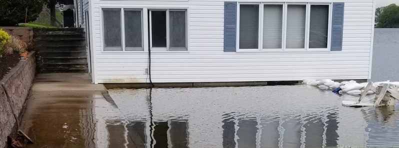
Image credit: Jaycelle
Lake Ontario daily average water level rose to record-high 75.89 m (248.98 feet) above sea level on May 31, 2019, breaking the previous record reached on four different dates in late May 2017 at 75.88 m (248.95 feet). The level is expected to rise in the coming weeks.
The record high water has inundated some low-lying properties, even in calm water, but the worst flooding occurs when winds generate larger waves that over-top and destroy shoreline protective structures and flood adjoining property, Rochester Democrat and Chronicle reports.
The current water level is about 82 cm (32.28 inches) above average for this time of year.
Toronto officials announced last week that the lake had hit 76.03 m (249.44 feet) above sea level – the highest point in recorded history.
The lake hit unprecedented highs in the spring and summer of 2017 when wind-and-wave events caused the worst sustained shoreline flooding in history. Then, both sides of the lake, in New York and the Canadian province of Ontario, thousands of residential and commercial properties suffered some amount of damage. Official damage total was not calculated, but it was estimated to cost $200 million or more.
Winds and waves are wreaking havoc again this spring. The worst event so far occurred on May 28, when northeast winds generated waves of 0.61 – 0.91 m (2 to 3 feet).
A flood outlook issued by the Hamilton Conservation Authority (HCA) on June 1 points to "record inflows" from Lake Erie and ongoing flooding in the St. Lawrence River as two factors behind the high water levels, CBS News said. "In of itself, these peak lake levels are not expected to cause significant shoreline flooding hazards, although continued localized flooding of the areas previously mentioned is expected," stated the HCA in a media release.
The outflow through the St. Lawrence River dam was increased by about two percent on June 1, the ninth such jump since mid-May.
LAKE ONTARIO WATER level 82 cm (32 inches) higher than average and rising, continuing into summer. Record inflows from Lake Erie, ongoing flooding along St. Lawrence. Winds from north, NE or east will cause storm surge. CBC story: https://t.co/13wBv5vY7A pic.twitter.com/FvXv1XUOIY
— Lance.Chronicle (@ChronicleLance) June 2, 2019
https://t.co/E5aKN5Yzl3
With #LakeOntario at record levels, any storms will result in serious #flooding.— John Clarke (@JohnOCAP) June 2, 2019
This morning was so peaceful on #lakeontario. I watched the sunrise and absorbed the ambient sound of everything waking up. Within the peace, the realisation set in. If the home is where the heart is, where is home? #canada @townofoakville #MondayMotivation #mondaythoughts pic.twitter.com/1VPFUukDZk
— Gareth (@IrishPixel) May 27, 2019
Sandbags not doing much to keep water from flowing into the parking lot from the lower #Niagara River here in Youngstown, NY. Some #flooding expected along parts of the #LakeOntario shore due to NW winds and already high lake levels. #nywx pic.twitter.com/lieBzaVXWS
— Kristian Ruggiero (@KrisRuggiero_WX) June 1, 2019
If precipitation stays near 'normal' and outflows through the dam continue to be stepped up, the lake should rise to about 75.91 m (249.07 feet) and peak in the next week or so, said Keith Koralewski, a hydraulic engineer for the U.S. Army Corps of Engineers who advises the lake-level regulators, according to Rochester Democrat and Chronicle.
The daily water level that held the record until May 2017, 75.82 m (248.75 feet), was set in June 1952, before the control dam on the St. Lawrence was built. Lake-level records go back to 1860, Rochester Democrat and Chronicle said.
The lake level is calculated daily by averaging hourly readings from government-run gauges at Oswego, Rochester and Port Weller, Ontario on the south shore, and Toronto, Cobourg and Kingston, Ontario on the north shore.
According to Hamilton Conservation Authority, serious flooding and hazards are possible in the coming weeks if "substantial storm surge and wave action occurs" – especially if the wind blows from the north, northeast or east.
The conservation authority is reminding people to be cautious near lakefront areas and says staff will continue to monitor wind conditions and lake levels closely.
The levels in Lake Ontario and the St. Lawrence River have dual impacts on the hydroelectric interests. Primarily, the levels on Lake Ontario dictate the outflows as determined in the Plan of Regulation. Secondarily, the levels of Lake St. Lawrence are the headwater for the Moses-Saunders Power Plant near Massena/Cornwall. Higher Lake St. Lawrence levels increase the head and therefore increase the output of generation, and conversely, lower Lake St. Lawrence levels lower the head thereby reducing generation. The flow in the St. Lawrence River provides the source of water used for hydroelectric developments near Cornwall/Massena operated by Ontario Power Generation and New York Power Authority, and near Montreal by Hyrdo Quebec. Together, these facilities have the potential to generate approximately 3,000 megawatts. And hifh Lake Levels increase Boat Shipping. Can we all say Greed ???
https://www.youtube.com/watch?v=282rDcf3IKE