
Heavy to excessive rainfall possible across a large part of Central U.S.
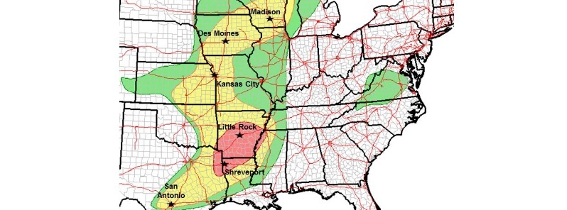
Image credit: NWS WPC
Heavy to excessive rainfall is possible across a large part of Central U.S. today and tonight, May 8 and 9, 2019, NWS WPC warns.
The most likely region is from the ArkLaTex into central Arkansas where WPC has a moderate risk. Remember when encountering flooded roads to turn around, don't drown!
Heavy to excessive rainfall possible across a large part of Central U.S. today and tonight. Most likely region is from the ArkLaTex into central Arkansas where WPC has a moderate risk. Remember when encountering flooded roads to turn around, don't drown! https://t.co/RPBzEMwsqM pic.twitter.com/8LoygOdrTz
— NWS WPC (@NWSWPC) May 8, 2019
A low pressure system currently stationed over the Central Plains will begin moving eastward as it produces heavy rain and thunderstorms for parts of the Central/Southern Plains and the eastern half of the CONUS tonight through Friday, May 10, 2019, NWS forecaster Kebede noted 19:55 UTC (15:55 EDT), May 8.
The cold front associated with this system will dip southeastward through northern Texas tonight and will interact with a plume of gulf moisture tomorrow leading to widespread heavy rainfall and thunderstorms over eastern Texas and much of the Southeast through Friday night.
I'm a dedicated researcher, journalist, and editor at The Watchers. With over 20 years of experience in the media industry, I specialize in hard science news, focusing on extreme weather, seismic and volcanic activity, space weather, and astronomy, including near-Earth objects and planetary defense strategies. You can reach me at teo /at/ watchers.news.
Commenting rules and guidelines
We value the thoughts and opinions of our readers and welcome healthy discussions on our website. In order to maintain a respectful and positive community, we ask that all commenters follow these rules.