
Powerful Pacific storm impacting California; Major multi-faceted storm Friday through weekend
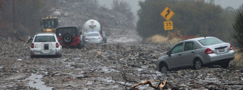
Image credit: Highway 38 and the road leading into Forest Falls remains closed due to mudslides. Image copyright: Stan Lim (@stanlimphoto)
A dynamic Pacific storm is delivering heavy to excessive rainfall, mountain snow, gusty winds and high surf to California. This system will evolve into a major multi-faceted storm Friday through the weekend, with severe weather in the South and heavy snow in parts of the Midwest.
Heavy rain and mountain snow is spreading across California and will bring the risk of flooding, mudslides and travel delays into Friday, AccuWeather meteorologists report.
Measurable rain is expected in the state’s largest cities, including in Los Angeles, San Diego, San Francisco and Sacramento.
Mandatory evacuations have already been issued for people living near the Holy Fire burn scar due to the potential for flooding and mudslides, while those in Malibu near the Woolsey Fire burn scar have been put on alert for potential evacuation.
Highway 38 and the road leading into Forest Falls remains closed due to mudslides that trapped several motorist. pic.twitter.com/UFKLJqRxxd
— Stan Lim (@stanlimphoto) November 29, 2018
Rain replaced smoke early last week, but how much rain has fallen since then? Over 10 inches for Coastal North Bay peaks, Santa Cruz mountains, and Big Sur peaks. 1.5-5 for most urban/valley locations. #cawx pic.twitter.com/zHFAm4tjHk
— NWS Bay Area (@NWSBayArea) November 30, 2018
High Surf Advisory indeed! Waves crashing over the promenade here in #Pacifica, CA.#CAwx @weatherchannel #weatherchannel @RobMayeda @NWSBayArea @nbcbayarea @breakingweather @accuweather @WeatherNation pic.twitter.com/Wvh5z6oubF
— Savannah Peterson (@SavIsSavvy) November 29, 2018
Several roads across the Golden State have already been closed following debris flows near the burn scars of recent wildfires, including the Ferguson Fire, Camp Fire and Holy Fire.
A cold front brought heavy rain, isolated thunderstorms and even dime-sized hail to portions of Santa Barbara County on November 29, capping off a two-day rain event that broke a Santa Maria record and dumped more than four inches of rain on some county mountains.
The storm broke a 112-year-old rainfall record at the Santa Maria Public Airport. As of 5:18 p.m., the Hancock Field rain gauge reported receiving 18 mm (0.71 of an inch) of rain, surpassing the 13.9 mm (0.55 of an inch) recorded in 1906.
An active weather pattern will be developing across the Plains by Friday night as surface cyclogenesis takes place over the Texas Panhandle region and Oklahoma in response to an amplifying upper level trough, NWS forecaster Hamrick noted November 30.
After producing widespread snow showers across the Rockies on Friday, precipitation expands in coverage and intensity from the Gulf Coast to the Upper Midwest and northern plains by Friday night and into Saturday morning.
In the warm sector of the developing surface low, multiple episodes of severe weather are becoming increasingly likely from southern Louisiana to the ArkLaTex region.
The Storm Prediction Center currently has much of that region delineated in an enhanced risk area for severe thunderstorms, given favorable wind shear and thermodynamic parameters that are expected to exist.
There will also be the potential for some heavy rain and perhaps some localized flooding across parts of the middle Mississippi River valley and also near the Florida Panhandle, where 50.8 mm (2 inches) of rain or more will be possible.
Winter weather will also be a major component of this mid-latitude cyclone to the north and west of the occluded surface low.
Winter storm watches and warnings are currently in effect from central Montana to northern Iowa, with the potential for 203.2 mm (8 inches) or more of snow, especially across southern South Dakota and northern Nebraska.
Blizzard conditions will also be possible at times given the strong pressure gradient that is anticipated north of the surface low, making travel conditions hazardous.
Temperatures are expected to be quite mild ahead of the cold front from the southern plains to the Mid-Atlantic and points south through early Sunday.
Afternoon highs could be as much as 8 to 11 °C (15 to 20 °F) above normal south of the warm front, with readings well into the 70s and reaching the mid 80s (°F) across much of Florida.
Much colder weather will become established over much of the Intermountain West and then the northern plains by the end of the forecast period on Sunday.
I'm a dedicated researcher, journalist, and editor at The Watchers. With over 20 years of experience in the media industry, I specialize in hard science news, focusing on extreme weather, seismic and volcanic activity, space weather, and astronomy, including near-Earth objects and planetary defense strategies. You can reach me at teo /at/ watchers.news.
Commenting rules and guidelines
We value the thoughts and opinions of our readers and welcome healthy discussions on our website. In order to maintain a respectful and positive community, we ask that all commenters follow these rules.