
Intense eruption continues at Krakatau, alert level remains at 2 of 4, Indonesia
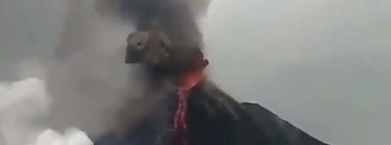
Image credit: Fobos Planet
Mount Anak Krakatau erupted 56 times on Saturday, September 22, 2018, the Meteorology, Climatology, and Geophysics Agency (BMKG) reported September 23. The alert level remains at Level II (Waspada/Caution).
Thick black smoke produced by the eruptions rose up o 200 – 300 m (650 – 1000 feet), the Mount Anak Krakatau monitoring post said.
The last VONA was issued at 22:56 UTC, September 21. It was related to an eruption at 22:48 UTC, recorded with a seismogram with a maximum amplitude of 45 mm. The eruption lasted about 115 seconds, producing ash column that rose up to 538 m (1 722 feet) above sea level, drifting south.
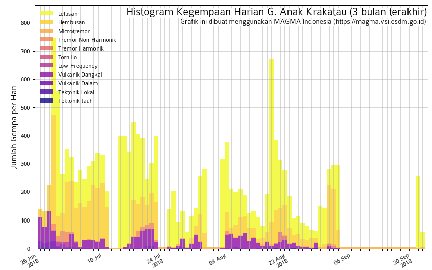
Image credit: Magma Indonesia
Based on satellite data, the Darwin VAAC reported that during September 11 – 13 and 17 – 18, ash plumes from Anak Krakatau rose to altitudes of 1. 5- 1.8 km (5 000 – 6 000 feet) above sea level and drifted NW, W, and SW. Ash plumes on September 8 rose to altitudes of 4.9 – 5.5 km (16 000 – 18 000 feet) a.s.l.
Photo of eruption at #Krakatau volcano yesterday, 9th September. The photographer, Aris Yanto, informed me that a new lava-flow was currently active on the Southern flank of Anak-Krakatau, as also seen on the photo. Photo: Aris Yanto. pic.twitter.com/97iUiEvQjl
— Øystein L. Andersen (@OysteinLAnderse) September 10, 2018
#Krakatau volcano. Photos showing eruptive activity at Anak-Krakatau – 2nd September. Indonesian Authorities (via @vulkanologi_mbg) recorded 85 seismic eruption events and 199 seismic degassing (Ind: `Hembusan`) events at Krakatau during 2nd September. Photos: Ronny Valstad pic.twitter.com/Rp4HXYAUBu
— Øystein L. Andersen (@OysteinLAnderse) September 3, 2018
The Alert Level remains at 2 (on a scale of 1 – 4): residents and visitors were warned not to approach the volcano within 2 km (1.2 miles) of the crater.
The Aviation Color Code remains ORANGE.
Geological summary
The renowned volcano Krakatau (frequently misstated as Krakatoa) lies in the Sunda Strait between Java and Sumatra. The collapse of the ancestral Krakatau edifice, perhaps in 416 CE, formed a 7-km-wide (4.3 miles) caldera.
Remnants of this ancestral volcano are preserved in Verlaten and Lang Islands; subsequently Rakata, Danan and Perbuwatan volcanoes were formed, coalescing to create the pre-1883 Krakatau Island. Caldera collapse during the catastrophic 1883 eruption destroyed Danan and Perbuwatan volcanoes, and left only a remnant of Rakata volcano.
This eruption, the 2nd largest in Indonesia during historical time, caused more than 36 000 fatalities, most as a result of devastating tsunamis that swept the adjacent coastlines of Sumatra and Java. Pyroclastic surges traveled 40 km (25 miles) across the Sunda Strait and reached the Sumatra coast.
After a quiescence of less than a half century, the post-collapse cone of Anak Krakatau (Child of Krakatau) was constructed within the 1883 caldera at a point between the former cones of Danan and Perbuwatan. Anak Krakatau has been the site of frequent eruptions since 1927. (GVP)
I'm a dedicated researcher, journalist, and editor at The Watchers. With over 20 years of experience in the media industry, I specialize in hard science news, focusing on extreme weather, seismic and volcanic activity, space weather, and astronomy, including near-Earth objects and planetary defense strategies. You can reach me at teo /at/ watchers.news.
Commenting rules and guidelines
We value the thoughts and opinions of our readers and welcome healthy discussions on our website. In order to maintain a respectful and positive community, we ask that all commenters follow these rules.