
Two tropical storms form close to Mexico – John and Ileana, warnings issued
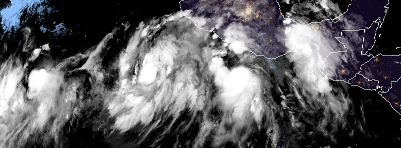
Featured image: Tropical storms John and Ileana at 03:00 UTC on August 6, 2018. Credit: NOAA GOES-East, RAMMB/CIRA
Two tropical storms formed close to Mexico over the past 12 hours, threatening the region with heavy rain, strong winds, and life-threatening surf and rip current conditions.
Tropical Storm "Ileana" formed 21:00 UTC on August 5, about 265 km (165 miles) SSW of Puerto Escondido, Mexico.
At 03:00 UTC on August 6, its maximum sustained winds were 85 km/h (50 mph) and the system was moving WNW at 20 km/h (13 mph) with minimum central pressure of 1 001 hPa.
The government of Mexico issued a Tropical Storm Warning from Lazaro Cardenas to Cabo Corrientes. Tropical storm conditions are expected in this area within 36 hours.
On the forecast track, Illeana's center is expected to move parallel to and offshore of the coast of southwestern Mexico through Tuesday, August 7.
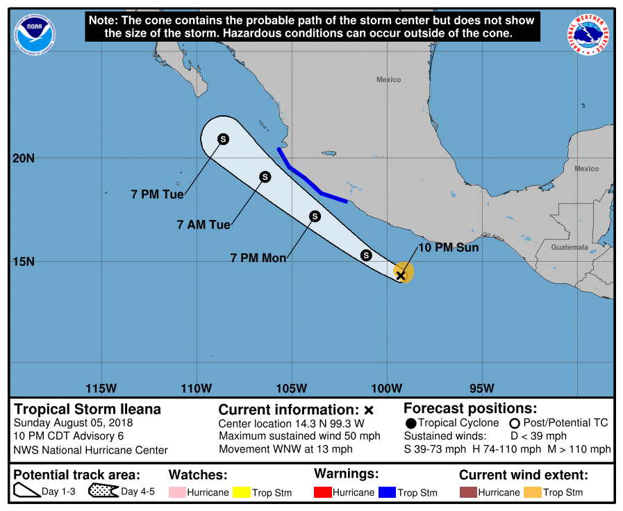
This system is expected to produce total rain accumulations of 51 to 102 mm (2 to 4 inches) over coastal sections of the Mexican states of Guerrero, Michoacan, Colima, and Jalisco, with possible isolated maximum amounts of 152 mm (6 inches) through Tuesday night. These rains may cause flash flooding.
Swells generated by Ileana will be affecting portions of the coast of southwestern Mexico during the next couple of days. These swells are likely to cause life-threatening surf and rip current conditions.
Additional strengthening is forecast today, but Ileana is forecast to dissipate by Tuesday night or Wednesday due to its proximity to much-larger Tropical Storm "John" to its west and southwest.
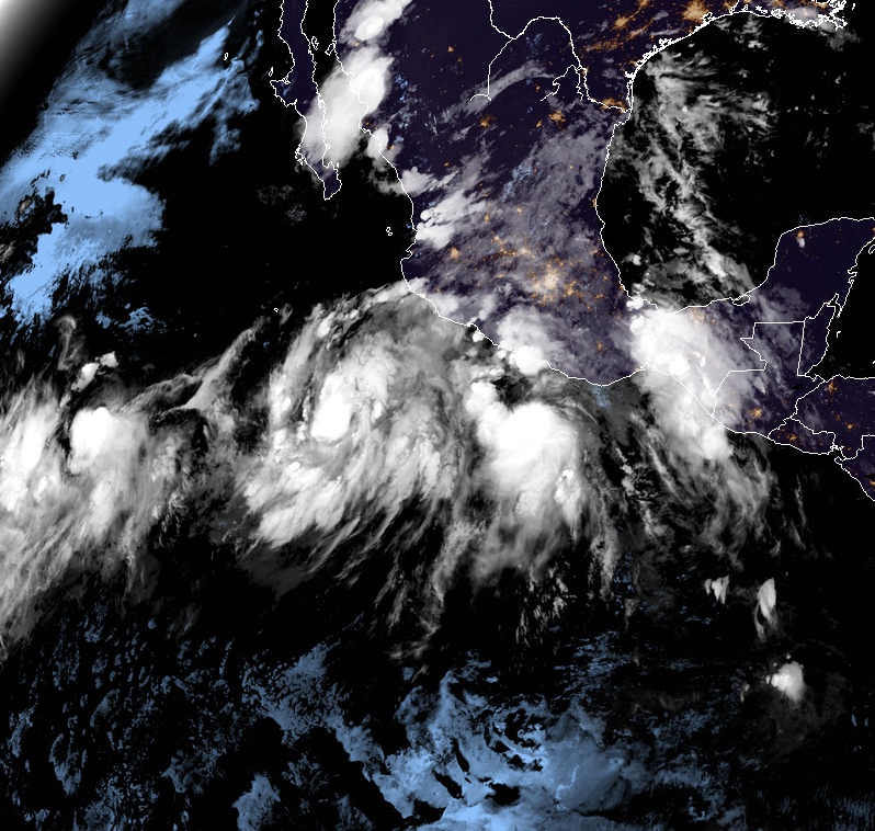
Tropical storms John and Ileana at 03:00 UTC on August 6, 2018. Credit: NOAA GOES-East, RAMMB/CIRA
Tropical Storm "John" formed 03:00 UTC on August 6 when its center was located about 500 km (310 miles) SSW of Manzanillo, Mexico. The storm had maximum sustained winds of 65 km/h (40 mph) at the time and was moving NW at 13 km/h (8 mph). Its minimum central pressure was 1 004 hPa.
This general motion with some increase in forward speed is expected over the next few days.
John is expected to be in an environment of very warm sea surface temperatures, low vertical wind shear, and a moist atmosphere over the next 60 hours.
This environment is quite favorable for rapid intensification, and it is likely that this will begin as soon as the inner core of the storm becomes better organized.
The NHC forecast calls for the storm to become a hurricane in 24 to 36 hours and to reach a peak intensity of 175 km/h (110 mph) in about 3 days.
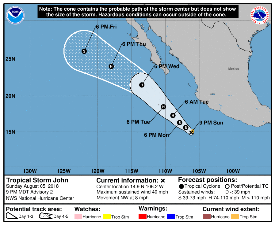
After that, the forecast track takes John over rapidly cooling sea surface temperatures, which should cause at least a steady weakening.
"The intensity forecast is in best agreement with the intensity consensus," NHC forecaster Jack Beven said. "It should be noted, however, that the SHIPS and LGEM models both show more intensification than the official forecast and make John a major hurricane in about three days."
John is the 10th named storm of the 2018 Pacific hurricane season.
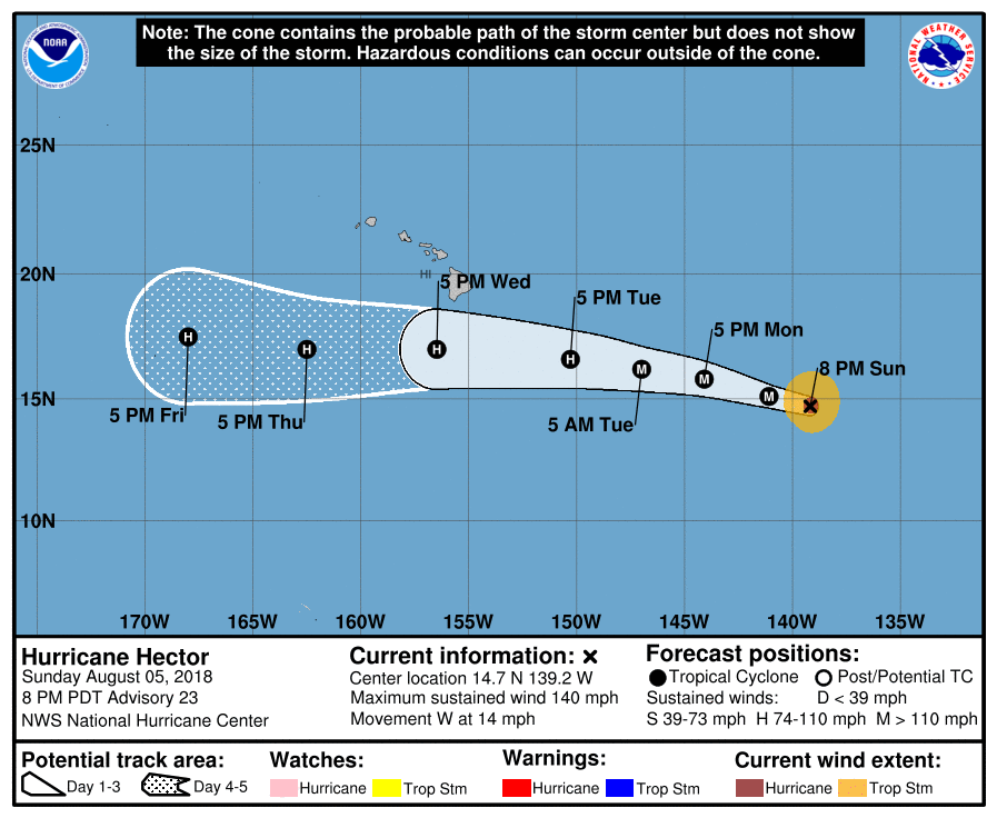
Meanwhile, another tropical system – Hector – is expected to cross into the Central Pacific basin as a Category 4 hurricane.
At 03:00 UTC, the center of Hurricane "Hector" was located 1 820 km (1 130 miles) ESE of South Point, Hawaii. Its maximum sustained winds were 220 km/h (140 mph) at the time, and the system was moving W at 22 km/h (14 mph) with minimum central pressure of 947 hPa.
There are currently no coastal watches or warnings in effect for this storm. However, interests in the Hawaiian Islands should monitor its progress.
"While the official forecast track continues to lie south of the Hawaiian Islands, only a slight deviation to the north of the forecast track would significantly increase potential impacts on the Hawaiian Islands," Beven noted.
Now is a good time for everyone in the Hawaiian Islands to ensure that they have their hurricane plan in place.
For additional information on any potential local impacts from Hector in Hawaii, please refer to products issued by the NWS Weather Forecast Office in Honolulu at: http://www.prh.noaa.gov/hnl.
I'm a dedicated researcher, journalist, and editor at The Watchers. With over 20 years of experience in the media industry, I specialize in hard science news, focusing on extreme weather, seismic and volcanic activity, space weather, and astronomy, including near-Earth objects and planetary defense strategies. You can reach me at teo /at/ watchers.news.
Commenting rules and guidelines
We value the thoughts and opinions of our readers and welcome healthy discussions on our website. In order to maintain a respectful and positive community, we ask that all commenters follow these rules.