
Very strong and shallow M6.4 earthquake hits Taiwan, major damage reported

Image credit: USGS
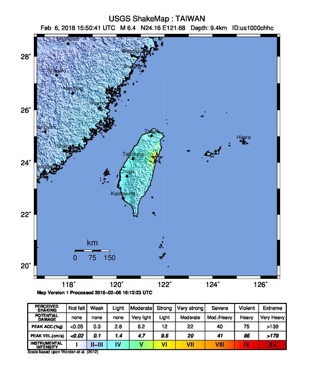
A strong and shallow earthquake registered by the USGS as M6.4 hit Hualien County of eastern Taiwan at 15:50 UTC (23:50 local time) on February 6, 2017. The agency is reporting a depth of 9.5 km (5.9 miles). EMSC is reporting M6.3 at a depth of 15 km (9.3 miles). Taiwan Seismological Center (CWB) is reporting M6.0 at a depth of 10 km (6.2 miles). This is the second M6+ earthquake to hit the region over the past 2 days after M6.1 at 13:56 UTC on February 4 and dozens of aftershocks.
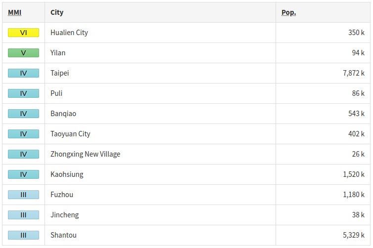
According to the USGS, the epicenter was located 21.4 km (13.3 miles) NNE of Hualien City (population 350 468), 66.8 km (41.5 miles) S of Yilan (population 94 188), 75.3 km (46.8 miles) ENE of Puli (population 86 406) and 89.6 km (55.6 miles) SSE of Daxi (population 84 549), Taiwan.
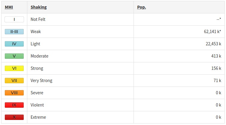
There are 7 260 000 people living within 100 km (62 miles) and 9 700 within 10 km.
Some 71 000 people are estimated to have felt very strong shaking (Hualien City and Tailuge), 156 000 strong, 413 000 moderate and 22 453 000 weak.
This earthquake is expected to have a medium humanitarian impact based on the magnitude and the affected population and their vulnerability.
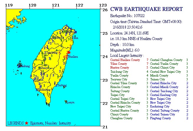
CWB registered 4 aftershocks with magnitudes ranging from 4.1 – 5.0 over the next 36 minutes.
The USGS issued a green alert for shaking-related fatalities and yellow alert for economic losses. Some damage is possible and the impact should be relatively localized. Past events with this alert level have required a local or regional level response.economic losses. There is a low likelihood of casualties and damage.
Overall, the population in this region resides in structures that are resistant to earthquake shaking, though vulnerable structures exist. The predominant vulnerable building types are adobe block and mid-rise nonductile concrete frame with infill construction.
Recent earthquakes in this area have caused secondary hazards such as landslides that might have contributed to losses.
Updates
17:09 UTC
Major damage reports are coming in:
Breaking: Major damage reported following Magnitude 6.5 earthquake in Taiwan. pic.twitter.com/KVB6RgPYuT
— PM Breaking News (@PMBreakingNews) February 6, 2018
Breaking: Rescue operations underway after magnitude 6.5 earthquake strikes Taiwan. pic.twitter.com/jZHubnWTFb
— PM Breaking News (@PMBreakingNews) February 6, 2018
A hotel in Hualien has collapsed.
18:37 UTC:
At least 2 people have been killed and more than 100 injured.
Rescue efforts are in progress after many partially tilted buildings.
Numerous roads and several bridges have been damaged.
13:28 UTC, February 7
The death toll has risen to 7 and the number of injured to 254. There are at least 554 people displaced.
07:47 UTC, February 15
The death toll stands at 17. There are now 270 people injured and 800 displaced.
This was the strongest earthquake to hit the city of Hualien ever.
Estimated population exposure to earthquake shaking
Selected cities exposed
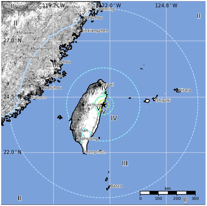
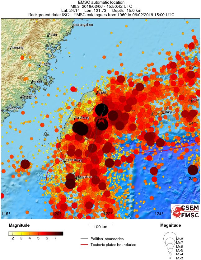
Regional seismicity
Tectonic summary
The February 6, 2018, M6.4 earthquake north-northeast of Hualien, Taiwan, occurred as the result of oblique strike-slip faulting at shallow depth, near the plate boundary between the Philippine Sea and Eurasia plates at the northeast coast of Taiwan. Preliminary focal mechanism solutions for the earthquake indicate rupture occurred on a steep fault striking either east-southeast (right-lateral), or south-southwest (left-lateral). At the location of this earthquake, the Philippine Sea plate converges with the Eurasia plate at a velocity of approximately 75 mm/yr towards the northwest. The location, depth and mechanism of the February 6, 2018. earthquake are consistent with its occurrence on, or along a fault in close proximity and relation to, the complex plate boundary in this region.
Taiwan lies in a region of complex tectonics near the intersection of three major tectonic plates – the Philippine Sea plate to the east and southeast, the Eurasia plate to the north and west, and the Sunda plate to the southwest. The location of the February 6, 2018 earthquake lies near the end of the Ryukyu subduction zone, which marks the plate boundary between the Philippine Sea and Eurasia plates in this region. The plate boundary in Taiwan itself is characterized by a zone of arc-continent collision; whereby the northern end of the Luzon (Philippines) island arc is colliding with the buoyant crust of the Eurasia continental margin offshore China. Along Taiwan’s west coast, and continuing south, this collision zone transitions into the eastward-oriented Manila subduction zone.
The February 6, 2018 earthquake is the largest in a sequence of events in the same region over the past several days. Beginning with a M4.8 earthquake on February 3, 2018, there have been 19 earthquakes of M4.5 and larger (as of February 6, 2018, 20:00 UTC). A M 6.1 earthquake occurred as a result of thrust-type faulting on February 4, 2018, just a few kilometers southeast of this M 6.4 earthquake on February 6th.
Because of its plate boundary location, Taiwan commonly experiences moderate-to-large earthquakes. The region within 250 km of today’s earthquake has hosted 184 other M6+ earthquakes over the preceding century; 25 of these were M7+. These include a M7.1 earthquake in September 1922, 25 km to the northeast of the February 6, 2018 earthquake, and a M7.1 event in March 2002, 55 km to the northeast. The 2002 event resulted in at least 5 fatalities, over 200 injuries, 3 collapsed buildings and the destruction of over 100 houses in the Taipei area. The September 1999, M7.7 Chi Chi earthquake occurred in central Taiwan, 81 km to the southwest of today’s earthquake. That earthquake resulted in at least 2 297 fatalities, and caused damage estimated at $14 billion.
Seismotectonics of the Philippine Sea and vicinity
The Philippine Sea plate is bordered by the larger Pacific and Eurasia plates and the smaller Sunda plate. The Philippine Sea plate is unusual in that its borders are nearly all zones of plate convergence. The Pacific plate is subducted into the mantle, south of Japan, beneath the Izu-Bonin and Mariana island arcs, which extend more than 3,000 km along the eastern margin of the Philippine Sea plate. This subduction zone is characterized by rapid plate convergence and high-level seismicity extending to depths of over 600 km. In spite of this extensive zone of plate convergence, the plate interface has been associated with few great (M>8.0) ‘megathrust’ earthquakes. This low seismic energy release is thought to result from weak coupling along the plate interface (Scholz and Campos, 1995). These convergent plate margins are also associated with unusual zones of back-arc extension (along with resulting seismic activity) that decouple the volcanic island arcs from the remainder of the Philippine Sea Plate (Karig et al., 1978; Klaus et al., 1992).
South of the Mariana arc, the Pacific plate is subducted beneath the Yap Islands along the Yap trench. The long zone of Pacific plate subduction at the eastern margin of the Philippine Sea Plate is responsible for the generation of the deep Izu-Bonin, Mariana, and Yap trenches as well as parallel chains of islands and volcanoes, typical of circum-pacific island arcs. Similarly, the northwestern margin of the Philippine Sea plate is subducting beneath the Eurasia plate along a convergent zone, extending from southern Honshu to the northeastern coast of Taiwan, manifested by the Ryukyu Islands and the Nansei-Shoto (Ryukyu) trench. The Ryukyu Subduction Zone is associated with a similar zone of back-arc extension, the Okinawa Trough. At Taiwan, the plate boundary is characterized by a zone of arc-continent collision, whereby the northern end of the Luzon island arc is colliding with the buoyant crust of the Eurasia continental margin offshore China.
Along its western margin, the Philippine Sea plate is associated with a zone of oblique convergence with the Sunda Plate. This highly active convergent plate boundary extends along both sides the Philippine Islands, from Luzon in the north to the Celebes Islands in the south. The tectonic setting of the Philippines is unusual in several respects: it is characterized by opposite-facing subduction systems on its east and west sides; the archipelago is cut by a major transform fault, the Philippine Fault; and the arc complex itself is marked by active volcanism, faulting, and high seismic activity. Subduction of the Philippine Sea Plate occurs at the eastern margin of the archipelago along the Philippine Trench and its northern extension, the East Luzon Trough. The East Luzon Trough is thought to be an unusual example of a subduction zone in the process of formation, as the Philippine Trench system gradually extends northward (Hamburger et al., 1983). On the west side of Luzon, the Sunda Plate subducts eastward along a series of trenches, including the Manila Trench in the north, the smaller less well-developed Negros Trench in the central Philippines, and the Sulu and Cotabato trenches in the south (Cardwell et al., 1980). At its northern and southern terminations, subduction at the Manila Trench is interrupted by arc-continent collision, between the northern Philippine arc and the Eurasian continental margin at Taiwan and between the Sulu-Borneo Block and Luzon at the island of Mindoro. The Philippine fault, which extends over 1,200 km within the Philippine arc, is seismically active. The fault has been associated with major historical earthquakes, including the destructive M7.6 Luzon earthquake of 1990 (Yoshida and Abe, 1992). A number of other active intra-arc fault systems are associated with high seismic activity, including the Cotabato Fault and the Verde Passage-Sibuyan Sea Fault (Galgana et al., 2007).
Relative plate motion vectors near the Philippines (about 80 mm/yr) is oblique to the plate boundary along the two plate margins of central Luzon, where it is partitioned into orthogonal plate convergence along the trenches and nearly pure translational motion along the Philippine Fault (Barrier et al., 1991). Profiles B and C reveal evidence of opposing inclined seismic zones at intermediate depths (roughly 70-300 km) and complex tectonics at the surface along the Philippine Fault.
Several relevant tectonic elements, plate boundaries and active volcanoes, provide a context for the seismicity presented on the main map. The plate boundaries are most accurate along the axis of the trenches and more diffuse or speculative in the South China Sea and Lesser Sunda Islands. The active volcanic arcs (Siebert and Simkin, 2002) follow the Izu, Volcano, Mariana, and Ryukyu island chains and the main Philippine islands parallel to the Manila, Negros, Cotabato, and Philippine trenches.
Seismic activity along the boundaries of the Philippine Sea Plate (Allen et al., 2009) has produced 7 great (M>8.0) earthquakes and 250 large (M>7) events. Among the most destructive events were the 1923 Kanto, the 1948 Fukui and the 1995 Kobe (Japan) earthquakes (99,000, 5,100, and 6,400 casualties, respectively), the 1935 and the 1999 Chi-Chi (Taiwan) earthquakes (3,300 and 2,500 casualties, respectively), and the 1976 M7.6 Moro Gulf and 1990 M7.6 Luzon (Philippines) earthquakes (7,100 and 2,400 casualties, respectively). There have also been a number of tsunami-generating events in the region, including the Moro Gulf earthquake, whose tsunami resulted in more than 5000 deaths. (USGS)
I'm a dedicated researcher, journalist, and editor at The Watchers. With over 20 years of experience in the media industry, I specialize in hard science news, focusing on extreme weather, seismic and volcanic activity, space weather, and astronomy, including near-Earth objects and planetary defense strategies. You can reach me at teo /at/ watchers.news.
Commenting rules and guidelines
We value the thoughts and opinions of our readers and welcome healthy discussions on our website. In order to maintain a respectful and positive community, we ask that all commenters follow these rules.