
GPM observatory examines the powerful US Northeast storm

Image credit: NASA/Goddard
The remnants of Tropical Storm "Philippe" had merged with another system and brought gusty winds and heavy rainfall to New England. The Global Precipitation Measurement mission or GPM core observatory satellite flew over the northeastern United States on Monday, October 30, 2017, and gathered data on the powerful storm that was affecting the region.
GPM passed over the region on October 30, 2017, at 00:36 UTC (20:36 EDT). The observatory had a good view of rainfall associated with a rapidly deepening developing low pressure system off the Atlantic Coast.
The remnants of Tropical Storm "Philippe," that formed on Sunday, October 29 and dissipated on Monday, October 30 were also merging with the intensifying low.

GPM passed over the northeastern U.S. on October 30, 2017 at 00:36 UTC. The approximate location of the storm's center at the time of the GPM pass is shown with a large red "L". A large area of intense rain was located in the Atlantic east of the low's center. GMI estimated that rain in that area was falling at rates of greater than 51 mm (2 inches) per hour. Credit: NASA/JAXA, Hal Pierce
The GPM satellite showed the distribution and intensity of precipitation on the eastern side of the low pressure center. GPM's Microwave Imager (GMI) showed that a large area of intense rain was located in the Atlantic east of the low's center. GMI estimated that rain in that area was falling at rates of greater than 51 mm (2 inches) per hour. GPM's Precipitation Radar (DPR) instrument showed that the low was dropping rain at a rate of over 125 mm (4.92 inches) per hour in a small area along the Massachusetts coast.
GPM's radar data also showed the height of the freezing level in the storm. The average freezing level was indicated by DPR data to be at 3.4 km (2.1 miles). Those data indicated that the freezing level sloped from a little above 0.9 km (0.5 miles) in southern Quebec to higher than 4.7 km (2.9 miles) in the Atlantic Ocean well east of the coast.
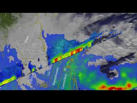
The 3-D images of the storm were produced at NASA's Goddard Space Flight Center in Greenbelt, Maryland using GPM's radar data (DPR Ku band). These probes by GPM's radar showed the location and structure of precipitation within the low pressure system. The highest storm tops in the system were revealed by DPR to reach heights of about 9 km (5.6 miles).

Heavy rain produced by the storm triggered both flash and river flooding across the region, stranding cars and forcing road closures. Gusts of wind greater that 113 km/h (70 mph) were reported within the storm.
Over a 1.5 million households lost power by the end of Monday, October 30.
As of 20:00 UTC on Tuesday, October 31, there were 612 510 customers still without power. 356 268 in Maine, 115 217 in New Hampshire, 83 339 in Massachusetts, and 83 686 in Rhode Island.

Earlier reporting
Nothing on Watchers was published in the last 24 hours. These are older articles.
- 2 atmospheric rivers to bring heavy Sierra snow and California flood risk
- CPC posts a slight risk of heavy rain from the Gulf Coast to the Northeast urban corridor November 25-29, and a moderate risk of West Coast wind and Sierra snow on November 25
- The storms drenching California this week are fed by a river in the sky, a band of water vapor that can carry up to 15 times the flow of the Mississippi River, and this winter’s near-record El Niño could keep aiming more of them at the West Coast
- Atmospheric river brings moderate risk of heavy rain, mountain snow and high winds to northern California and southwest Oregon on November 24-25
