
First significant cold blast expected in Europe late this weekend
Featured image: GFS 850 hPa temperature anomaly for November 3, 2017. Credit: TropicalTidbits.com
A sharp patter change is expected to affect Europe starting late this weekend with much colder temperatures than average.
"Various models are in good agreement for a sharp pattern change starting late this weekend from northern Europe spreading into east-central Europe and Balkan peninsula next week," Severe Weather Europe meteorologists warned.
"An upper ridge will develop across western Europe and North Atlantic, blocking the zonal mild flow from the west while a deep trough/cyclones will be forming over Scandinavia and northwestern Russia. This will allow an establishment of meridional flow and advection of very cold airmass towards the Alps and Balkan peninsula," they explained.
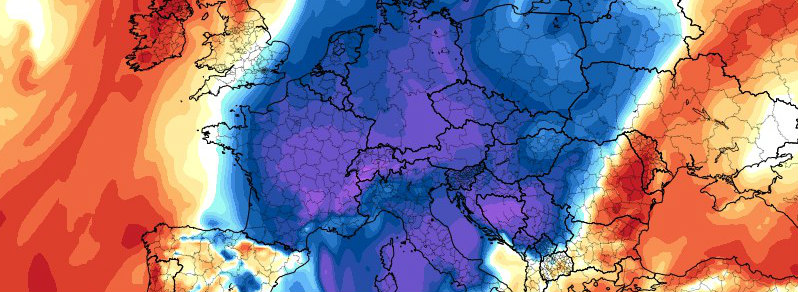
As visible on the GFS Temperature Anomaly model below, the first blast is expected on Sunday, October 28, followed by a day or two of slightly warmer temperatures before the second blast arrives. The second blast is expected to reach northern Africa.
850 hPa Temperature Anomaly (GFS)
2-meter Air Temperature (GFS)
2-meter Temperature Anomaly (GFS)
I'm a dedicated researcher, journalist, and editor at The Watchers. With over 20 years of experience in the media industry, I specialize in hard science news, focusing on extreme weather, seismic and volcanic activity, space weather, and astronomy, including near-Earth objects and planetary defense strategies. You can reach me at teo /at/ watchers.news.
Commenting rules and guidelines
We value the thoughts and opinions of our readers and welcome healthy discussions on our website. In order to maintain a respectful and positive community, we ask that all commenters follow these rules.