
Powerful, fast-moving Hurricane “Nate” to slam into US Gulf Coast
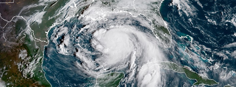
Featured image: Hurricane "Nate" at 13:45 UTC on October 7, 2017. Credit: NOAA/GOES-16
After killing at least 22 people in Central America, Nate is now a Category 1 hurricane on its way toward the US Gulf Coast. Its center will move across the central and northern Gulf of Mexico today and make landfall as Category 1 hurricane or stronger along the central U.S. Gulf coast tonight (CDT). Nate is bringing heavy rain, powerful winds, dangerous storm surge and life-threatening surf and rip-conditions. Isolated tornadoes will be possible beginning later today over parts of the central Gulf Coast region. This is a powerful and fast-moving storm.
Nate prompted evacuations in low-lying coastal Louisiana parishes and Alabama and Mississippi and many preparations have already taken place. However, those still underway need to be rushed to completition as conditions along the coast will rapidly deteriorate starting Saturday afternoon (local time). Nate will most likely be a strong Category 1 hurricane possibly Category 2 as it makes landfall Saturday evening into Saturday night (CDT).
Vulnerable, low-lying coastal areas, such as New Orleans; Mobile, Alabama; Biloxi, Mississippi; and Pensacola, Florida, should treat Nate as a serious threat for flooding from heavy rain and storm surge, AccuWeather's meteorologists warn. "New Orleans levees that have been upgraded since Katrina and pumps that have been repaired in recent weeks may be tested this weekend," according to AccuWeather Expert Meteorologist and Chief Operating Officer Evan Myers.
The fast-forward motion of the storm will push more water inland on its eastern and northern side, when compared to a slow-moving storm of equal strength.
At 12:00 UTC (07:00 CDT) on October 7, 2017, the center of Hurricane "Nate" was located 395 km (245 miles) SSE of the mouth of the Mississippi River. Nate has maximum sustained winds of 135 km/h (85 mph) and is moving NNW at 45 km/h (22 mph) with minimum central pressure of 986 hPa.
This general fast motion is expected to continue through tonight. A turn toward the north is forecast on Sunday morning, followed by a turn toward the north-northeast thereafter.
On the forecast track, the center of Nate will move across the central and northern Gulf of Mexico today and will make landfall along the central U.S. Gulf coast tonight (CDT). Some additional strengthening is possible before Nate makes landfall along the northern Gulf coast.
Hurricane-force winds extend outward up to 55 km (35 miles) from the center and tropical-storm-force winds extend outward up to 205 km (125 miles).
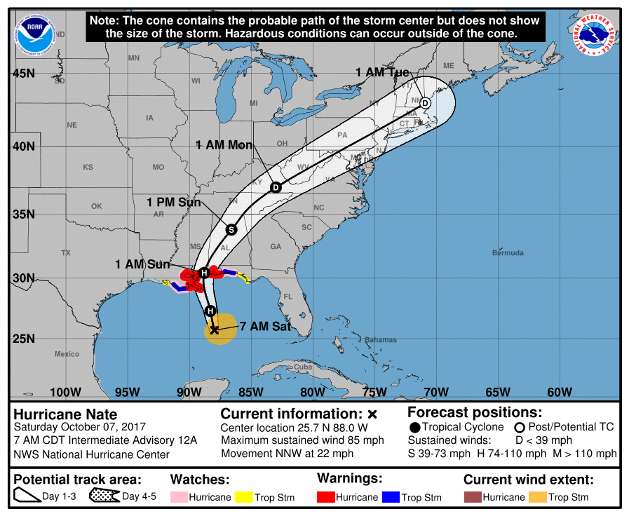
Hurricane Warning is in effect for:
- Grand Isle Louisiana to the Alabama/Florida border
- Metropolitan New Orleans and Lake Pontchartrain
A Hurricane Warning means that hurricane conditions are expected somewhere within the warning area, in this case within the next 24 hours. Preparations to protect life and property should be rushed to completion.
A Storm Surge Warning is in effect for:
- Morgan City Louisiana to the Okaloosa/Walton County Line Florida
- Northern and western shores of Lake Pontchartrain
A Tropical Storm Warning is in effect for:
- Lake Maurepas
- West of Grand Isle to Morgan City Louisiana
- East of the Alabama/Florida border to the Okaloosa/Walton County Line
A Tropical Storm Warning means that tropical storm conditions are expected somewhere within the warning area.
A Hurricane Watch is in effect for:
- Lake Maurepas
- East of the Alabama/Florida border to the Okaloosa/Walton County Line
- West of Grand Isle to Morgan City Louisiana
A Hurricane Watch means that hurricane conditions are possible within the watch area.
A Storm Surge Watch is in effect for:
- East of the Okaloosa/Walton County Line to Indian Pass Florida
A Storm Surge Watch means there is a possibility of life-threatening inundation, from rising water moving inland from the coastline, in the indicated locations during the next 48 hours.
A Tropical Storm Watch is in effect for:
- East of the Okaloosa/Walton County Line to Indian Pass Florida
- West of Morgan City to Intracoastal City Louisiana
A Tropical Storm Watch means that tropical storm conditions are possible within the watch area.
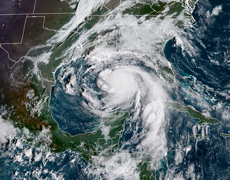
Hurricane "Nate" at 13:45 UTC on October 7, 2017. Credit: NOAA/GOES-16
Hazards affecting land
Along the northern Gulf Coast, hurricane conditions are expected in the hurricane warning area tonight, with tropical storm conditions expected to begin earlier. Tropical storm conditions are expected in the tropical storm warning area tonight. Hurricane conditions are possible in the hurricane watch area tonight and tropical storm conditions are possible in the tropical storm watch area tonight and Sunday.
In the United States, the combination of a dangerous storm surge and the tide will cause normally dry areas near the coast to be flooded by rising waters moving inland from the shoreline. The water is expected to reach the following heights above ground if the peak surge occurs at the time of high tide:
- Morgan City, Louisiana to the mouth of the Mississippi River: 1.2 to 1.8 m (4 to 6 feet)
- Mouth of the Mississippi River to the Alabama/Florida border: 1.5 to 2.7 m (5 to 9 feet)
- Alabama/Florida border to the Okaloosa/Walton County Line: 1.2 to 1.8 m (4 to 6 feet)
- Okaloosa/Walton County Line to Indian Pass, Florida: 0.6 – 1.2 m (2 to 4 feet)
- Indian Pass to Crystal River, Florida: 0.3 to 0.9 m (1 to 3 feet)
The deepest water will occur along the immediate coast near and to the east of the landfall location, where the surge will be accompanied by large and destructive waves. Surge-related flooding depends on the relative timing of the surge and the tidal cycle, and can vary greatly over short distances.
Nate is expected to produce the following rain accumulations through Monday:
- Eastern Yucatan and western Cuba: 50.8 – 101.6 mm (2 to 4 inches), max 152.4 mm (6 inches)
- Eastern Belize and the Cayman Islands: 25.4 to 76.2 mm (1 to 3 inches)
- East of the Mississippi River from the central Gulf Coast into the Deep South, eastern Tennessee Valley, and the southern Appalachians: 76.2 to 152.4 mm (3 to 6 inches), max 254 mm (10 inches)
- Across the Ohio Valley into the central Appalachians: 50.8 – 101.6 mm (2 to 4 inches), max 152.4 mm (6 inches)
Isolated tornadoes will be possible beginning later today over parts of the central Gulf Coast region.
Swells generated by Nate will affect land areas around the western Gulf of Mexico during the next day or so. These swells are likely to cause life-threatening surf and rip current conditions.
I'm a dedicated researcher, journalist, and editor at The Watchers. With over 20 years of experience in the media industry, I specialize in hard science news, focusing on extreme weather, seismic and volcanic activity, space weather, and astronomy, including near-Earth objects and planetary defense strategies. You can reach me at teo /at/ watchers.news.
Commenting rules and guidelines
We value the thoughts and opinions of our readers and welcome healthy discussions on our website. In order to maintain a respectful and positive community, we ask that all commenters follow these rules.