
Hurricane “Max” about to hit Mexico, dangerous storm surge and heavy rain expected
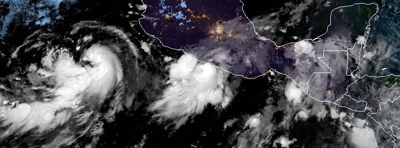
Featured image: Hurricane "Max" at 12:30 UTC on September 14, 2017. Credit: NOAA/GOES-16 (preliminary and non-operational)
Tropical Storm "Max" intensified into a Category 1 hurricane at 12:00 UTC on September 14, 2017. The government of Mexico has changed the Hurricane Watch and Tropical Storm Warning from Zihuatanejo to Punta Maldonado to a Hurricane Warning. A dangerous storm surge is expected to produce significant coastal flooding near and to the east of where the center makes landfall. Heavy rain produced by Max may produce life-threatening flash floods and mudslides.
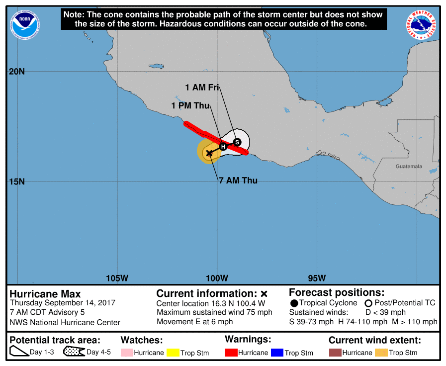
At 12:00 UTC on September 14, the center of Hurricane "Max" was located 85 km (55 miles) SW of Acapulco, Mexico. The system had maximum sustained winds of 120 km/h (75 mph) and was moving east at 9 km/h (6 mph). Its minimum central pressure was 992 hPa.
Some additional strengthening is possible before max hits the land along the southwestern coast of Mexico later today (local time).
A Hurricane Warning is in effect for Zihuatanejo to Punta Maldonado, Mexico. A Hurricane Warning means that hurricane conditions are expected somewhere within the warning area, in this case within the next 12 hours. Preparations to protect life and property should be rushed to completion.
Hurricane-force winds extend outward up to 20 km (10 miles) from the center, and tropical-storm-force winds extend outward up to 75 km (45 miles).
Max is expected to produce total rainfall accumulations of 127 to 254 mm (5 to 10 inches) in the Mexican state of Guerrero and western portions of the state of Oaxaca. Maximum amounts locally in excess of 508 mm (20 inches) are possible over coastal areas of Guerrero. These torrential rains may produce life-threatening flash floods and mudslides.
A dangerous storm surge is expected to produce significant coastal flooding near and to the east of where the center makes landfall. Near the coast, the surge will be accompanied by large and destructive waves.
I'm a dedicated researcher, journalist, and editor at The Watchers. With over 20 years of experience in the media industry, I specialize in hard science news, focusing on extreme weather, seismic and volcanic activity, space weather, and astronomy, including near-Earth objects and planetary defense strategies. You can reach me at teo /at/ watchers.news.
The Chinese troops (those that aren’t already here) are coming in from Mexico and Texas with their hardware.
Clearing out the DMZ zone all along the Gulf for this is likely.
DMZ ultimately to be 150 miles inland of all coasts?
We are clearing it all out for them, aren’t we? Is that’s what’s going on? Clearing out Christians simultaneously?
If the above is true, then we are presently being attacked from within.