
Harvey rapidly strengthened into a hurricane, expected to stall over Texas coast
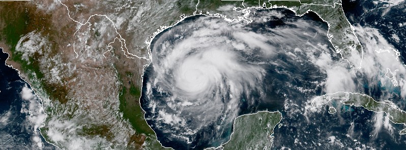
Featured image: Hurricane "Harvey" at 16:45 UTC on August 24, 2017. Credit: NOAA/GOES-16 (preliminary and non-operational)
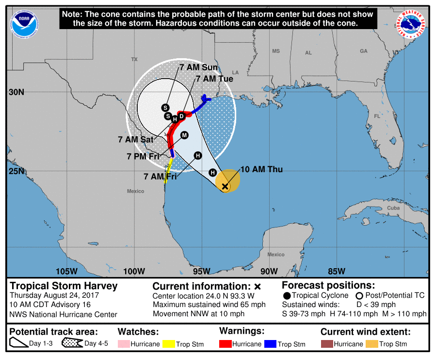
Tropical Storm "Harvey" rapidly strengthened into a hurricane today and is expected to become a major, Category 3 hurricane before it makes landfall over the coast of Texas late Friday or early Saturday (local time), August 25 or 26, 2017. Preparations for the arrival of this extremely dangerous storm should be well underway.
Harvey is expected to stall near the middle Texas coast through the weekend dumping very heavy rain and causing life-threatening flooding. The combination of a dangerous storm surge and the tide will cause normally dry areas near the coast to be flooded by rising waters moving inland from the shoreline. Life threatening swells generated by this storm are likely to affect Texas, Louisiana and northeast Mexico coast by Friday.
At 17:00 UTC (12:00 CDT) on August 24, 2017, the center of Hurricane "Harvey" was located about 550 km (340 miles) SE of Corpus Christi and 540 km (335 miles) SSE of Port O'Connor, Texas.
Harvey's maximum sustained winds were reaching 100 km/h (65 mph) at 15:00 UTC. However, by 17:00 they increased to 130 km/h (80 mph), making Harvey a Category 1 hurricane on the Saffir-Simpson scale. The system is moving NNW at 17 km/h (10 mph) with an estimated minimum central pressure of 981 hPa.
A turn toward the northwest is expected later today, and Harvey's forward speed is forecast to slow down during the next couple of days. On the current forecast track, Harvey will approach the middle Texas coast on Friday and make landfall Friday night or early Saturday, and then stall near the middle Texas coast through the weekend, NWS said.
Rapid strengthening is forecast, and Harvey is expected to become a major hurricane before it reaches the middle Texas coast.
Preparations for the arrival of this extremely dangerous storm should be well underway.
A Storm Surge Warning is in effect for:
Port Mansfield to San Luis Pass Texas.
A Storm Surge Warning means there is a danger of life-threatening inundation, from rising water moving inland from the coastline, during the next 36 hours in the indicated locations.
A Storm Surge Watch is in effect for:
South of Port Mansfield Texas to the Mouth of the Rio Grande
North of San Luis Pass to High Island Texas
A Storm Surge Watch means there is a possibility of life- threatening inundation, from rising water moving inland from the coastline, in the indicated locations during the next 48 hours.
A Hurricane Warning is in effect for:
Port Mansfield to Matagorda Texas
A Hurricane Warning means that hurricane conditions are expected somewhere within the warning area. A warning is typically issued 36 hours before the anticipated first occurrence of tropical-storm- force winds, conditions that make outside preparations difficult or dangerous. Preparations to protect life and property should be rushed to completion.
A Tropical Storm Warning is in effect for:
North of Matagorda to High Island Texas
South of Port Mansfield Texas to the Mouth of the Rio Grande
A Tropical Storm Warning means that tropical storm conditions are expected somewhere within the warning area within 36 hours.
A Hurricane Watch is in effect for:
South of Port Mansfield Texas to the Mouth of the Rio Grande
A Hurricane Watch means that hurricane conditions are possible within the watch area.
A Tropical Storm Watch is in effect for:
South of the Mouth of the Rio Grande to Boca de Catan Mexico
A Tropical Storm Watch means that tropical storm conditions are possible within the watch area.
Hurricane conditions are likely within the hurricane warning area late Friday or Friday night, with tropical storm conditions expected to first reach the coast in the hurricane warning area Friday.
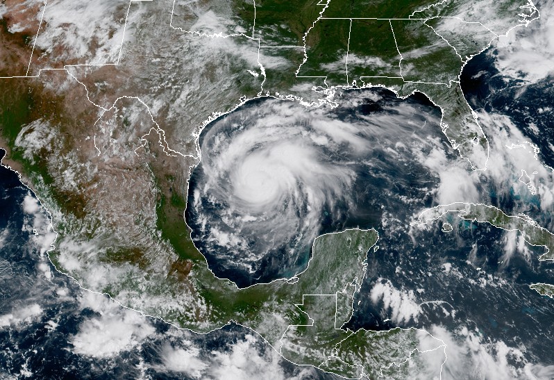
Hurricane "Harvey" at 16:45 UTC on August 24, 2017. Credit: NOAA/GOES-16 (preliminary and non-operational)
Harvey is expected to produce total rain accumulations of 305 to 508 mm (12 to 20 inches) and isolated maximum amounts of 762 mm (30 inches) over the middle and upper Texas coast through next Wednesday.
During the same time period, Harvey is expected to produce total rain accumulations of 127 to 305 mm (5 to 12 inches) in far south Texas and the Texas Hill Country to central Louisiana, with accumulations of less than 127 mm (5 inches) extending into other parts of Texas and the lower Mississippi Valley.
Rainfall from Harvey may cause life-threatening flooding.
The combination of a dangerous storm surge and the tide will cause normally dry areas near the coast to be flooded by rising waters moving inland from the shoreline. The water is expected to reach the following heights above ground if the peak surge occurs at the time of high tide:
N Entrance Padre Island Natl Seashore to Sargent: 1.8 to 3 m (6 to 10 feet)
Sargent to San Luis Pass: 1.5 to 2.1 m (5 to 7 feet)
Port Mansfield to N Entrance Padre Island Natl Seashore: 1.5 to 2.1 m (5 to 7 feet)
San Luis Pass to High Island: 0.6 to 1.2 m (2 to 4 feet)
Mouth of the Rio Grande to Port Mansfield: 0.6 to 1.2 m (2 to 4 feet)
High Island to Morgan City: 0.3 to 0.9 m (1 to 3 feet)
The deepest water will occur along the immediate coast near and to the northeast of the landfall location, where the surge will be accompanied by large and destructive waves. Surge-related flooding depends on the relative timing of the surge and the tidal cycle, and can vary greatly over short distances.
Swells generated by Harvey are likely to affect the Texas, Louisiana, and northeast Mexico coasts by Friday. These swells are likely to cause life-threatening surf and rip current conditions.
Note: NHC will issue a Special Advisory by 13:00 CDT (18:00 UTC) in lieu of the intermediate advisory to update the intensity forecast. This page will be updated accordingly.
I'm a dedicated researcher, journalist, and editor at The Watchers. With over 20 years of experience in the media industry, I specialize in hard science news, focusing on extreme weather, seismic and volcanic activity, space weather, and astronomy, including near-Earth objects and planetary defense strategies. You can reach me at teo /at/ watchers.news.
Commenting rules and guidelines
We value the thoughts and opinions of our readers and welcome healthy discussions on our website. In order to maintain a respectful and positive community, we ask that all commenters follow these rules.