
Tropical Storm “Dianmu” about to hit Vietnam, flash floods and landslides predicted
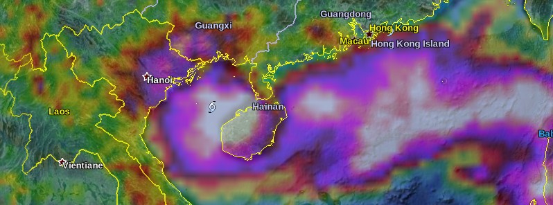
Featured image: 72 hours of rainfall accumulation ending 09:00 UTC on August 18, 2016. Credit: NASA/GSFC TRMM, Google
As of August 18, 2016, there are three tropical cyclones with fourth possibly developing in the Northwest Pacific Ocean, the most active basin on the planet. The biggest threat over the next 24 to 48 hours is Tropical Cyclone "Dianmu" which is forecast to hit the coast of northern Vietnam between 09:00 and 15:00 UTC on August 19. Deluges are predicted at river systems in northern and north-central deltas whereas flash floods and landslides are imminent in mountainous regions.
A low-pressure area located about 190 km (120 miles) ESE of Hong Kong got upgraded by the Japan Meteorological Agency (JMA) to a tropical depression on August 15, 2016. On August 17, the Hong Kong Weather Observatory (HKO) upgraded the system into a tropical depression too. JTWC started tracking the system later on the same day, with the designation 11W. Early on August 18, JMA named this system Dianmu.
At 12:00 UTC on August 18, Dianmu's center was located about 50 km (31 miles) NNW of the northeastern coast of Hainan, and about 250 km (154 miles) E of Hai Phong, Vietnam. At the time, the maximum speed near the center was 65 km/h (40 mph) while maximum wind gust speed was reaching 92.6 km/h (57 miles), according to the JMA. Dianmu had the central pressure of 985 hPa.
At 15:00 UTC, Dianmu's center was located approximately 115 km (71 miles) NW of Haikou, China. The system is tracking westward at 29.6 km/h (18.4 mph), JTWC said. Animated enhanced infrared satellite imagery depicts a broad area of deep flaring convection that appears to have accelerated in the last six hours making its way over the Leizhou Peninsula and into the Gulf of Tonkin.
Environmental conditions are currently marginal with vertical wind shear values near 46.3 km/h (28.8 mph) offset slightly by a strong equatorward outflow channel and warm sea surface temperatures near 30 to 31 °C (86 to 87.8 °F).
Dianmu will continue to track westward and make a landfall over the northern Vietnam within the next 24 hours. Slight intensification is expected as Dianmu consolidates over the warm waters of the Gulf of Tonkin reaching a peak intensity of 55.5 km/h (34.5 mph) before it makes landfall and dissipates within the next 48 hours.
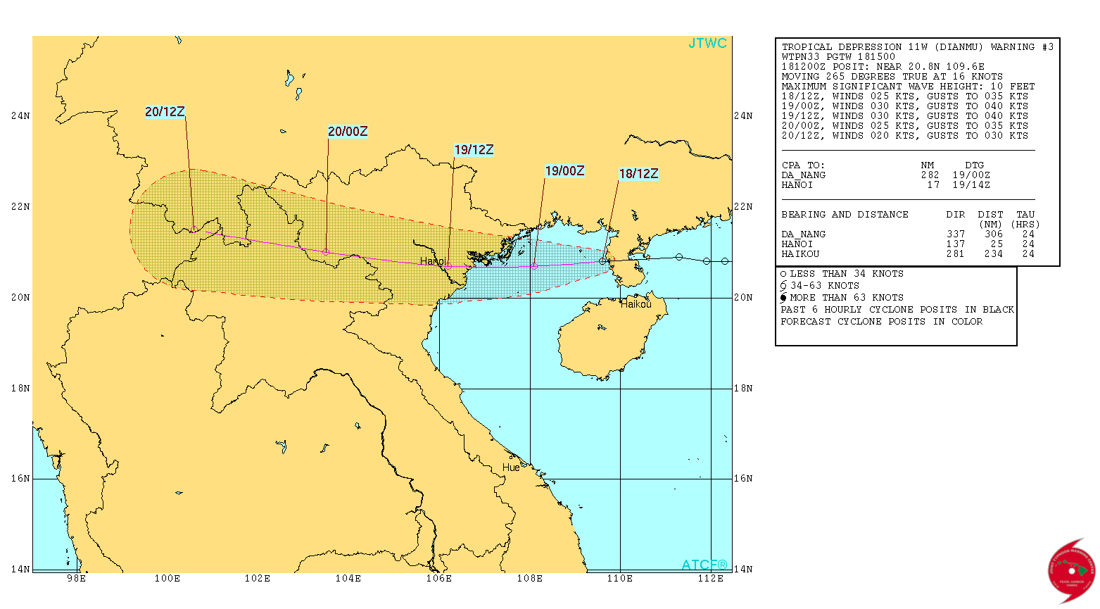
According to Vietnam's National Center for Hydro-Meteorological Forecasting (NCHMF), Dianmu is forecast to make landfall near Thai Binh province at 09:00 UTC (16:00 local time) on Friday, August 19, with maximum sustained winds ranging from 90 to 120 km/h (56 to 74 mph).
With a large wind field radius at 200 km (124 miles), the cyclone is anticipated to significantly impact northern and north-central regions, the NCHMF said.
Severe downpours and lashing squalls are expected in many towns and cities, with 200 – 300 mm (7.9 to 11.8 inches), while some locations will experience over 500 mm (19.7 inches) of rain.
Deluges are predicted at river systems in northern and north-central deltas whereas flash floods and landslides are imminent in mountainous regions.
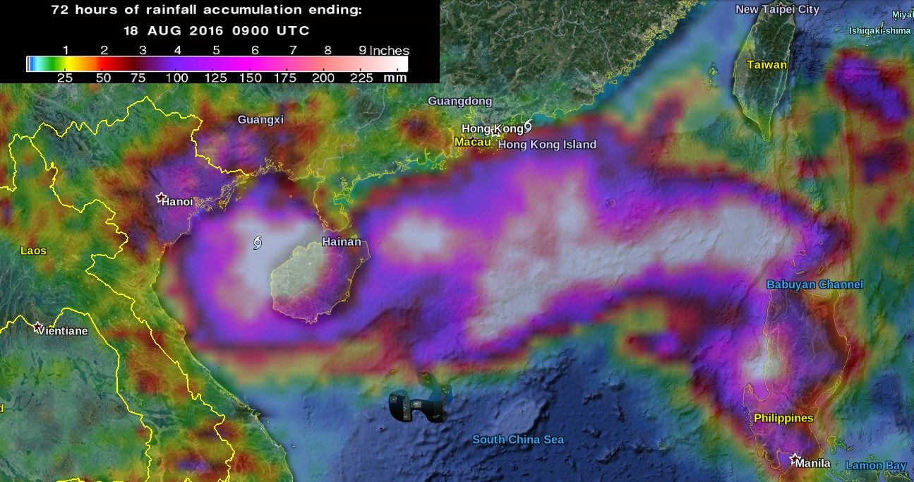
72 hours of rainfall accumulation ending 09:00 UTC on August 18, 2016. Credit: NASA/GSFC TRMM, Google
Nguyen Xuan Cuong, head of the Department of Natural Disaster Prevention and Control, urged local authorities on Thursday to enact preventive measures and provide updated information, as well as offering immediate support to the locals encountering trouble.
There are two more tropical cyclones elsewhere in the Northwest Pacific Ocean, visible on the IR Himawari image below:
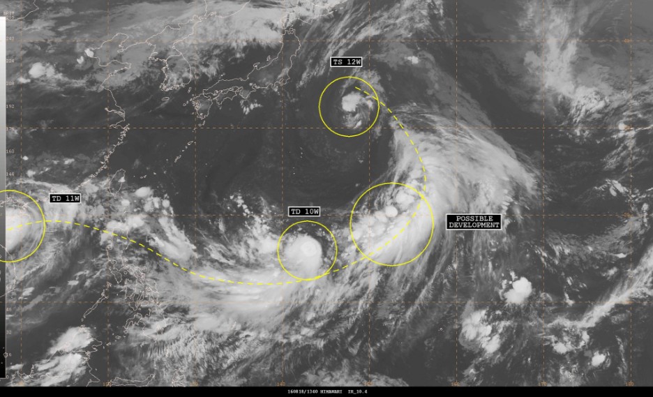
Image credit: JMA/Himawari. Annotation: NWS/OPC
Tropical Depression 12W
Tropical Depression 12W formed on August 16, about 690 km (430 mileS) NW of Wake Island. At 15:00 UTC on August 18, the system had maximum sustained winds of 74 km/h (46 mph) with gusts to 92.6 km/h (57.5 mph), according to JTWC.
After 15:00 UTC on August 19, the system will start turning WSW and then SW as the dominant steering mechanism transitions to the western subtropical ridge extending from China into western Japan. A modest intensification is expected.
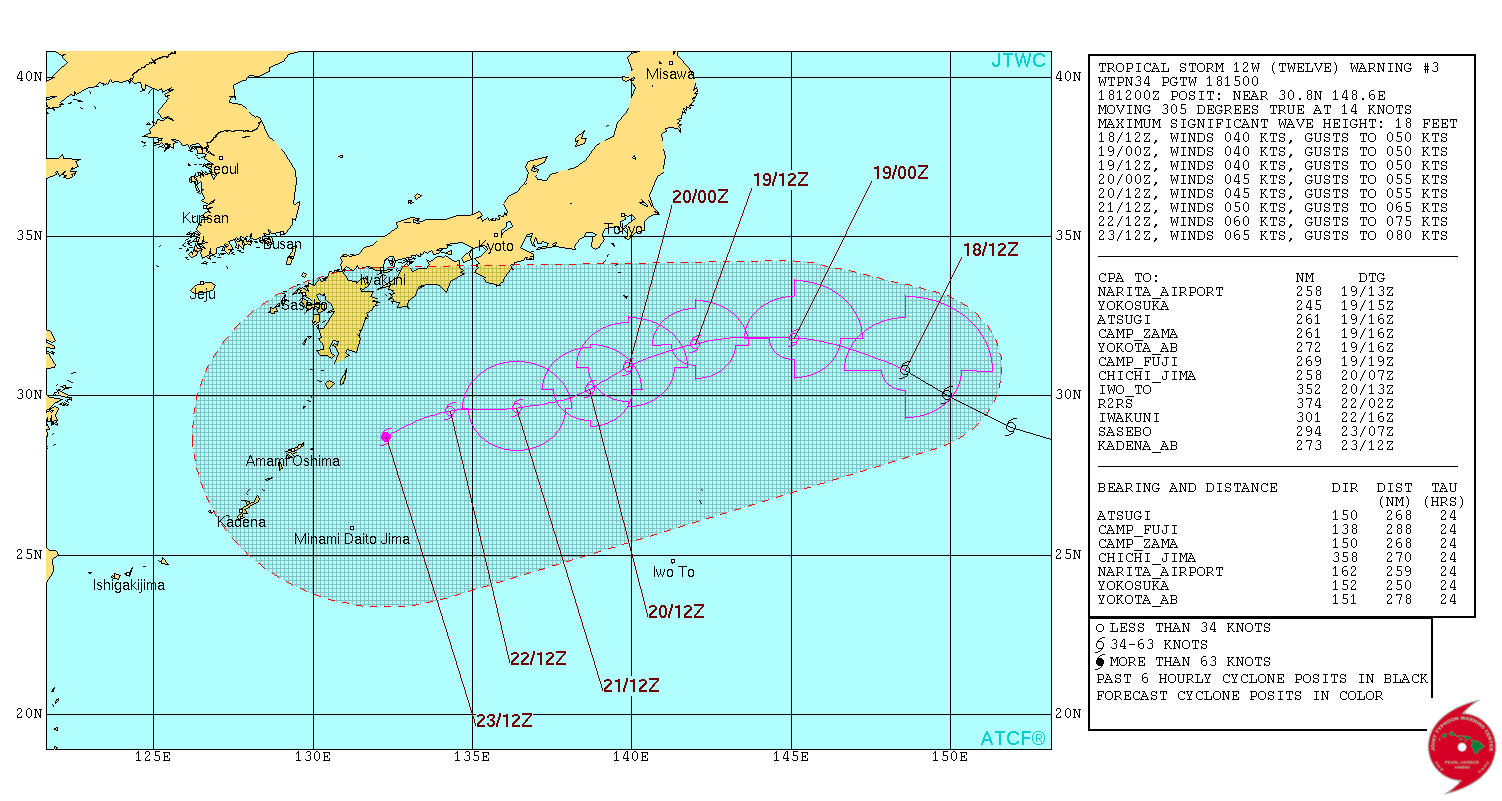
Tropical Depression 12W forecast track by JTWC on August 18, 2016
Tropical Depression 10W
Tropical Depression 10W formed northwest of Guam on August 17. At 15:00 UTC on August 18, its center was located about 290 km (180 miles) NNW of Saipan, Northern Mariana Islands. Its maximum sustained wind speed was 55.5 km/h (34.5 mph), according to the JTWC. 10W has tracked NNE at 16.7 km/h (10.3 mph) over the past six hours.
Environmental conditions are slowly improving, and 10W is forecast to intensify over the next 48 hours.
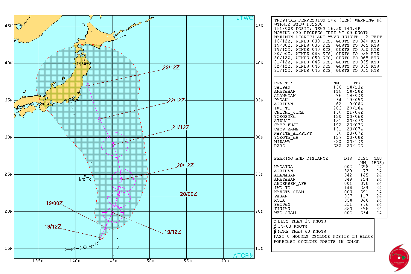
Tropical Depression 10W forecast track by JTWC on August 18, 2016
The Watchers team and our contributors bring the latest on extreme weather, earthquakes, volcanic eruptions, space weather, and all things science. We're all about making sense of the natural world and keeping you informed on what’s happening. Got a tip or a question? Hit us up using the form at newstips!
Commenting rules and guidelines
We value the thoughts and opinions of our readers and welcome healthy discussions on our website. In order to maintain a respectful and positive community, we ask that all commenters follow these rules.