
Two new lava flows observed at Kilauea volcano, Hawaii
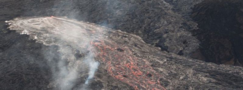
Image credit: USGS/HVO
Eruptive activity of the Kilauea volcano continues with two new lava flows observed at the northeast and east flank of the Pu'u ' O'o cone on May 24, 2016. The northeast flank flow was about 1 km (3 281 feet) long while the flow on the east flank of the volcano measured about 700 m (2 297 feet). The initial lava flows were intense, but they are not regarded as a threat to the nearby communities.
The new lava flows were reported around 6:50 am (local time), according to the Hawaiian Volcano Observatory (HVO). The first flow is situated approximately 250 m (820 feet) from the rim of the cone, and moving northwest while the second one is about 500 m (1 640 feet) from the rim of the cone, and heading southeast.
HVO reported the floor of the Pu'u 'O'o crater has slightly subsided with the newest activity while the persistent glow from spatter cones within the crater continues.
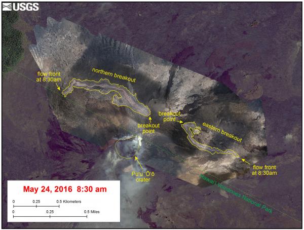
The map of two new breakouts at Puʻu ʻŌʻō, which began just before 7:00 a.m., HST, May 24, 2016, showing the extent of the lava flows based on aerial photos that were taken at 8:30 a.m. Image credit: USGS/HVO
The larger of the two breakouts at Puʻu ʻŌʻō, May 24, 2016, just before 7:00 a.m., HST. The breakout originated on the northeast flank of the cone, at the site of the vent for the ongoing June 27th lava flow. Image credit: USGS/HVO
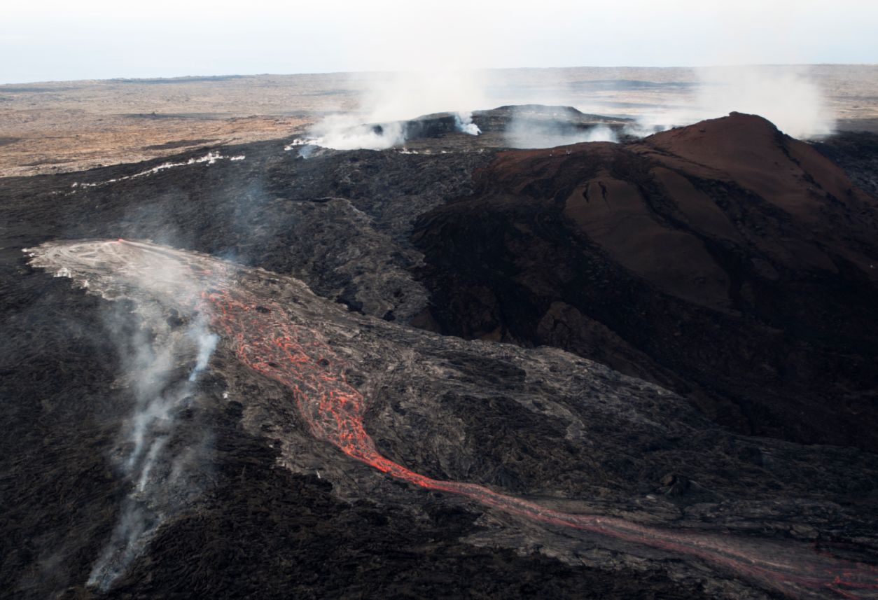
The second breakout, east of Puʻu ʻŌʻō, about 500 m (0.3 miles) from the crater, in the area of the "Peace Day" flow that broke out in September 2011. This second breakout was smaller than the one on the northeast flank. Image credit: USGS/HVO
Seismic activity remains unchanged, low and steady while the sulfur emission rate from all East Rift Zone vents was about 300 metric tons on May 10.
The summit lava lake level has risen slightly since May 24, and spattering has been intermittently visible from the Jaggar overlook on the morning of May 25 (local time). Scattered lava flow activity continued on the June 27th lava flow field within about 5.8 km (19 029 feet) northeast of Puʻu ʻŌʻō. A small flurry of deep earthquakes has been reported on the lower part of the southwest rift zone of the volcano over the past few days. Earthquakes in this area represent the usual behavior for Kīlauea Volcano.
The lava lake within the Halemaʻumaʻu Overlook crater remains active, its level at about 23 m (75 feet) below the Halema`uma`u crater floor. Tremor fluctuations related to the spattering of the lava lake have continued. Sulfur dioxide emissions from the summit vent ranged from typical values of 4 100 to 7 000 t/d during the past week.
Video credit: USGS/HVO
According to GVP, seismicity beneath the Kilauea's summit, upper East Rift Zone, and Southwest Rift Zone was at background levels during the period between May 11 and 17. The lava lake continued to circulate and eject spatter in the Overlook vent while the glow from multiple spatter cones on the Pu'u 'O'o Crater floor and from skylights in the lava tube on the NE flank of the cone were observed.
Vents in the SW and E parts of the crater periodically produced small lava flows within the crater, and the June 27th NE-trending lava flow continued to be active within 5.8 km (19 029 feet) NE of Pu'u 'O'o Crater.
Geological summary
Kilauea volcano, which overlaps the east flank of the massive Mauna Loa shield volcano, has been Hawaii's most active volcano during historical time. Eruptions of Kilauea are prominent in Polynesian legends; written documentation extending back to only 1820 records frequent summit and flank lava flow eruptions that were interspersed with periods of long-term lava lake activity that lasted until 1924 at Halemaumau crater, within the summit caldera.
The 3 x 5 km (1.9 x 3.1 miles) caldera was formed in several stages about 1500 years ago and during the 18th century; eruptions have also originated from the lengthy East and SW rift zones, which extend to the sea on both sides of the volcano. About 90% of the surface of the basaltic shield volcano is formed of lava flows less than about 1 100 years old; 70% of the volcano's surface is younger than 600 years. A long-term eruption from the East rift zone that began in 1983 has produced lava flows covering more than 100 sq km (37 sq miles), destroying nearly 200 houses and adding new coastline to the island. (GVP)
Commenting rules and guidelines
We value the thoughts and opinions of our readers and welcome healthy discussions on our website. In order to maintain a respectful and positive community, we ask that all commenters follow these rules.