
Blanca to impact southern Baja California as a tropical storm
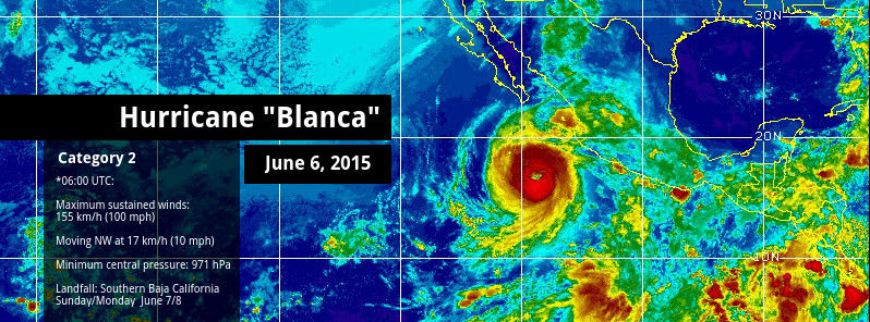
Image credit: Hurricane "Blanca" on June 6, 2015. Background image: GOES-WEST/UW-CIMSS. Edit: TW.
Hurricane "Blanca" lost its intensity over the past 48 hours and is now a Category 2 hurricane with a general weakening trend.
Blanca is facing increased wind shear, drier, more stable air, and cooler waters which will weaken her into a tropical storm as it approaches the southern Baja California peninsula. This will, however, generate life threatening conditions and Blanca is expected to make landfall late Sunday, June 7 into early Monday (local time).
A Tropical Storm Watch is in effect from La Paz to Santa Fe, including Cabo San Lucas, Mexico.
The forecast track has the storm and its remnants moving up the peninsula and the Gulf of California for several days.
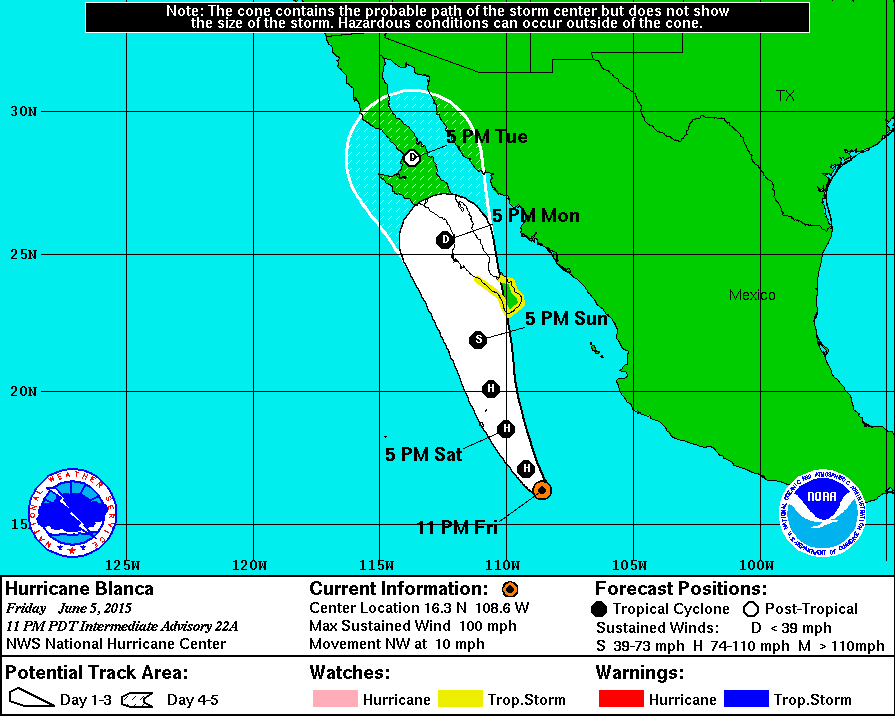
At 06:00 UTC on Saturday, June 6, Hurricane "Blanca" was located about 545 km (340 miles) WSW of Manzanillo and about 745 km (465 miles) S of Cabo San Lucas, Mexico. Maximum sustained winds were estimated at 155 km/h (100 mph) – Category 2 hurricane. The system is moving NW at 17 km/h (10 mph) with a minimum central pressure of 971 hPa.
NW motion is expected to continue through Saturday followed by a turn toward the NNW by Saturday evening (local time). On the current forecast track, the center of Blanca will approach the southern Baja California peninsula on Sunday, June 7.
Hurricane force winds extend outward up to 75 km (45 miles) from the center, and tropical storm force winds extend outward up to 315 km (195 miles).
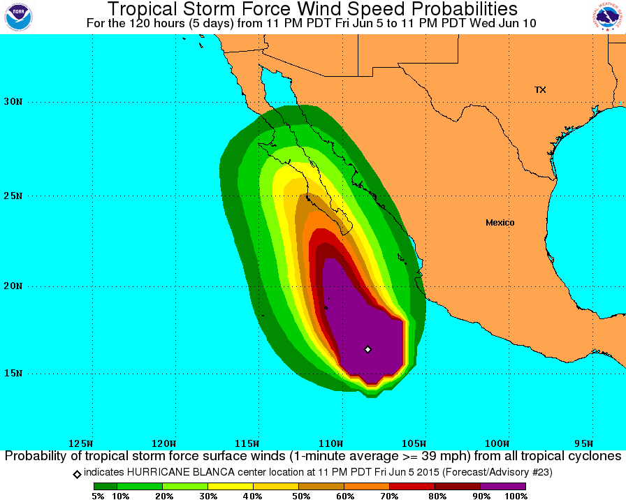
Swells generated by Blanca are affecting the coast of southwestern Mexico, the Pacific coast of the Baja California peninsula, and the southern Gulf of California. These swells are likely to cause life-threatening surf and rip current conditions, NWS NHC noted.
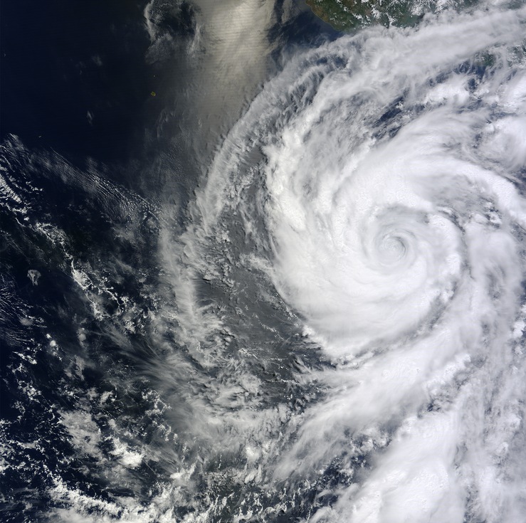
Hurricane "Blanca" on June 4, 2015. Image credit: NASA Terra/MODIS.
Tropical Storm "Blanca" formed on June 1, 2015 and rapidly intensified into a Category 4 hurricane on June 3, setting a new record as the earliest second hurricane in an eastern Pacific season (previously June 5), and as the earliest second major hurricane (previously June 12).
It did not manage to reach Category 5, which would make it the earliest Category 5 hurricane in the eastern Pacific (current record held by Hurricane "Ana" – June 6, 1973), but what Blanca showed is good enough to make all the preparations for above-normal eastern Pacific hurricane season.
The current El Niño helps make conditions favorable to hurricane growth in the Pacific (warmer water than usual) while tamping down conditions on the Atlantic side (increased wind shear and other atmospheric changes), NASA's EO said. NOAA scientists predicted 15 to 22 named storms in the eastern Pacific, of which 7 to 12 are expected to become hurricanes. They called for 6 to 11 named storms in the Atlantic, with 3 to 6 becoming hurricanes.
“These past two weeks have given us a preview of what should be a active, El Niño fueled Eastern Pacific hurricane season,” said Bill Patzert, climatologist at NASA’s Jet Propulsion Laboratory. “The west coast of Mexico should prepare for a battering this summer into the fall.”
.GIF)
Image credit: UW-CIMSS.
I'm a dedicated researcher, journalist, and editor at The Watchers. With over 20 years of experience in the media industry, I specialize in hard science news, focusing on extreme weather, seismic and volcanic activity, space weather, and astronomy, including near-Earth objects and planetary defense strategies. You can reach me at teo /at/ watchers.news.
Commenting rules and guidelines
We value the thoughts and opinions of our readers and welcome healthy discussions on our website. In order to maintain a respectful and positive community, we ask that all commenters follow these rules.