
Large lahars block access to the town of Ubinas, Peru
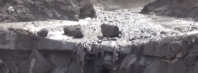
Image credit: IGP
According to Peru's Observatorio Volcanológico del Sur (OVS) snow melt during April 12 – 13, 2015 led to large lahars that descended the southern flank of Ubinas volcano blocking off access to the town of Ubinas. Authorities are warning locals to be on alert.
Seismic activity at the volcano increased on April 14 and is still being recorded. This instability generated the largest explosion of the year with ash plume rising to about 3.5 km.
More than 1 mm of ash fell on the towns of Querapi and Ubinas on several occasions during April. This might seem insignificant, LaCultureVolcan writes, but in reality even this amount of ash generated each time the volcano erupts causes various problems to nearby residents. People exposed to ash fall and subsequent ash-filled air commonly experience various eye, nose, and throat symptoms. Food and water can be contaminated.
People should avoid unnecessary exposure to ash and wear an effective face mask when outside to reduce inhalation of ash particles. Patients with chronic bronchitis, emphysema, and asthma should take special precaution to avoid exposure to ash particles and be aware that the use of any respirator other than single-use (disposable) respirator may cause additional cardio-pulmonary stress.
A much bigger and life threatening problems are lahars observed during snow melt on April 12 and 13 which blocked access road leading to the town of Ubinas.
USGS explains lahar as a hot or cold mixture of water and rock fragments flowing down the slopes of a volcano and (or) river valleys. When moving, a lahar looks like a mass of wet concrete that carries rock debris ranging in size from clay to boulders more than 10 m in diameter.
"Small lahars less than a few meters wide and several centimeters deep may flow a few meters per second. Large lahars hundreds of meters wide and tens of meters deep can flow several tens of meters per second – much too fast for people to outrun.
As a lahar rushes downstream from a volcano, its size, speed, and the amount of water and rock debris it carries constantly change. The beginning surge of water and rock debris often erodes rocks and vegetation from the side of a volcano and along the river valley it enters. This initial flow can also incorporate water from melting snow and ice (if present) and the river it overruns. By eroding rock debris and incorporating additional water, lahars can easily grow to more than 10 times their initial size. But as a lahar moves farther away from a volcano, it will eventually begin to lose its heavy load of sediment and decrease in size.
Eruptions may trigger one or more lahars directly by quickly melting snow and ice on a volcano or ejecting water from a crater lake. More often, lahars are formed by intense rainfall during or after an eruption – rainwater can easily erode loose volcanic rock and soil on hillsides and in river valleys. Some of the largest lahars begin as landslides of saturated and hydrothermally altered rock on the flank of a volcano or adjacent hillslopes. Landslides are triggered by eruptions, earthquakes, precipitation, or the unceasing pull of gravity on the volcano."
Geologic summary
A small, 1.4-km-wide caldera cuts the top of Ubinas, Peru's most active volcano, giving it a truncated appearance. It is the northernmost of three young volcanoes located along a regional structural lineament about 50 km behind the main volcanic front of Perú. The growth and destruction of Ubinas I was followed by construction of Ubinas II beginning in the mid-Pleistocene. The upper slopes of the andesitic-to-rhyolitic Ubinas II stratovolcano are composed primarily of andesitic and trachyandesitic lava flows and steepen to nearly 45 degrees.
The steep-walled, 150-m-deep summit caldera contains an ash cone with a 500-m-wide funnel-shaped vent that is 200 m deep. Debris-avalanche deposits from the collapse of the SE flank about 3700 years ago extend 10 km from the volcano. Widespread plinian pumice-fall deposits include one of Holocene age about 1000 years ago. Holocene lava flows are visible on the flanks, but historical activity, documented since the 16th century, has consisted of intermittent minor-to-moderate explosive eruptions. (GVP)
I'm a dedicated researcher, journalist, and editor at The Watchers. With over 20 years of experience in the media industry, I specialize in hard science news, focusing on extreme weather, seismic and volcanic activity, space weather, and astronomy, including near-Earth objects and planetary defense strategies. You can reach me at teo /at/ watchers.news.
Commenting rules and guidelines
We value the thoughts and opinions of our readers and welcome healthy discussions on our website. In order to maintain a respectful and positive community, we ask that all commenters follow these rules.