
State of emergency after powerful eruption at Ubinas volcano, 10 000 people affected, Peru
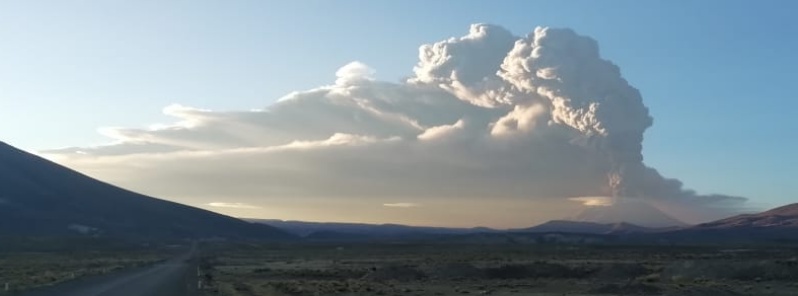
Image credit: IGP
The Government of Peru has declared a state of emergency for 12 districts located in four provinces of the regions of Moquegua, Arequipa, and Tacna on July 20 after violent eruptions started at Ubinas volcano early July 19, 2019. The emergency measure will be in effect for at least 60 days.
President of the Republic, Martín Vizcarra, said the declaration will allow regional governors and mayors to proceed quickly and have the budget to carry out care actions, purchase tools, acquisition of protection material and food for the population, among other measures for emergency care.
#Vídeo | Palabras de @presidenciaperu sobre #Ubinas.
Presidente Martín Vizcarra realizó una inspección al volcán Ubinas y destacó la labor del #IGP en el monitoreo del comportamiento dinámico del volcán.#ElPerúPrimero pic.twitter.com/xHNAYO0F4e— Instituto Geofísico del Perú (@igp_peru) July 20, 2019
According to data provided by the National Institute of Civil Defense (Indeci), ashfall has already affected 9 249 people in Moquegua, Arequipa, and Tacna. The volcano was placed on Orange alert on July 20, schools closed and protective masks delivered.
Specialists of the Direction of Meteorology and Environmental Evaluation of the Senamhi said the winds on Sunday, July 21 will displace the ashes towards the northeast at high levels (10 – 12 km / 6 7 miles) and towards the east at medium levels (6 -7 km / 3.7 – 4.3 miles). In general, temperatures during the day would be lower in the regions where the ashes will block solar radiation.
Violent explosions started at the volcano around 07:35 UTC (02:35 local time) on July 19, with volcanic ash reaching 12.1 km (42 000 feet) above sea level.
This is the highest eruption of the volcano since 1677 (VEI 3).
#IGPINFORMA Estas son imágenes de lo ocurrido en los alrededores del volcán Ubinas, las cuales dan cuenta de cómo se encuentra la región ante la intensa actividad explosiva. (1/1) pic.twitter.com/rRiMopyWIM
— Instituto Geofísico del Perú (@igp_peru) July 19, 2019
#ErupciónUbinas El #IGP te muestra imágenes recientemente captadas por nuestros colaboradores en la zona de Ubinas. ¡Mantente informado! pic.twitter.com/IWrtS1op3x
— Instituto Geofísico del Perú (@igp_peru) July 19, 2019
#Vídeo | Sobrevuelo en el volcán #Ubinas.
El @igp_peru, adscrito al Minam, conjuntamente con @indeciperu, realizan el reconocimiento de zonas afectadas. Participó el ingeniero Héctor Palza, director del IGP sede Arequipa.#ElPerúPrimero pic.twitter.com/l2F65bQBIo— Ministerio del Ambiente (@MinamPeru) July 20, 2019
#ErupciónUbinas Así amanece el volcán Ubinas, emitiendo continuamente cenizas, aunque con menor intensidad que lo registrado ayer. El material viene siendo dispersado hacia el sector sureste del volcán, según precisa @Senamhiperu.
El CENVUL continúa vigilando su actividad. pic.twitter.com/1IIkoS803U— Instituto Geofísico del Perú (@igp_peru) July 20, 2019
#ErupciónUbinas Desde muy temprano, especialistas del #IGP se encuentran en las inmediaciones del volcán #Ubinas realizando la limpieza de estaciones geofísicas y captando imágenes con cámaras científicas. pic.twitter.com/K59nHZt3ZI
— Instituto Geofísico del Perú (@igp_peru) July 20, 2019
Geological summary
A small, 1.4-km-wide (0.8 miles) caldera cuts the top of Ubinas, Peru's most active volcano, giving it a truncated appearance. It is the northernmost of three young volcanoes located along a regional structural lineament about 50 km (31 miles) behind the main volcanic front of Perú.
The growth and destruction of Ubinas I was followed by the construction of Ubinas II beginning in the mid-Pleistocene. The upper slopes of the andesitic-to-rhyolitic Ubinas II stratovolcano are composed primarily of andesitic and trachyandesitic lava flows and steepen to nearly 45 degrees. The steep-walled, 150-m-deep (492 feet) summit caldera contains an ash cone with a 500-m-wide (1 640 feet) funnel-shaped vent that is 200 m (656 feet) deep.
Debris-avalanche deposits from the collapse of the SE flank about 3 700 years ago extend 10 km (6.2 miles) from the volcano. Widespread plinian pumice-fall deposits include one of Holocene age about 1 000 years ago. Holocene lava flows are visible on the flanks, but historical activity, documented since the 16th century, has consisted of intermittent minor-to-moderate explosive eruptions. (GVP)
I'm a dedicated researcher, journalist, and editor at The Watchers. With over 20 years of experience in the media industry, I specialize in hard science news, focusing on extreme weather, seismic and volcanic activity, space weather, and astronomy, including near-Earth objects and planetary defense strategies. You can reach me at teo /at/ watchers.news.
Commenting rules and guidelines
We value the thoughts and opinions of our readers and welcome healthy discussions on our website. In order to maintain a respectful and positive community, we ask that all commenters follow these rules.