
Tropical Cyclone “Chedza” forms in Mozambique Channel, landfall over Madagascar today
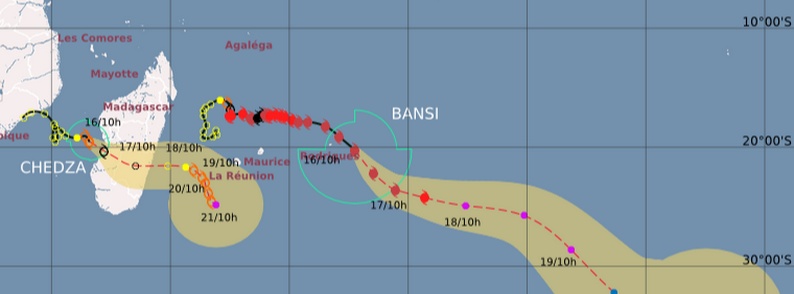
Image credit: Meteo France (RSMC La Reunion)
Tropical Cyclone "Chedza" is forming from System 93S in the Mozambique Channel today. Infrared image taken at 16:00 UTC on January 15 by METEOSAT-7 showed the system moved away from the coast of Mozambique and into the Mozambique Channel and was getting better organized. Clouds associated with System 93S' eastern side blanketed southern and central Madagascar yesterday.
At 16:00 UTC on January 15, System 93S was centered about 662 km (414 miles) west of Antananarivo, Madagascar. Its maximum sustained winds were between 37 – 46 km/h (23 – 28 mph), but the system was battered by moderate vertical wind shear.
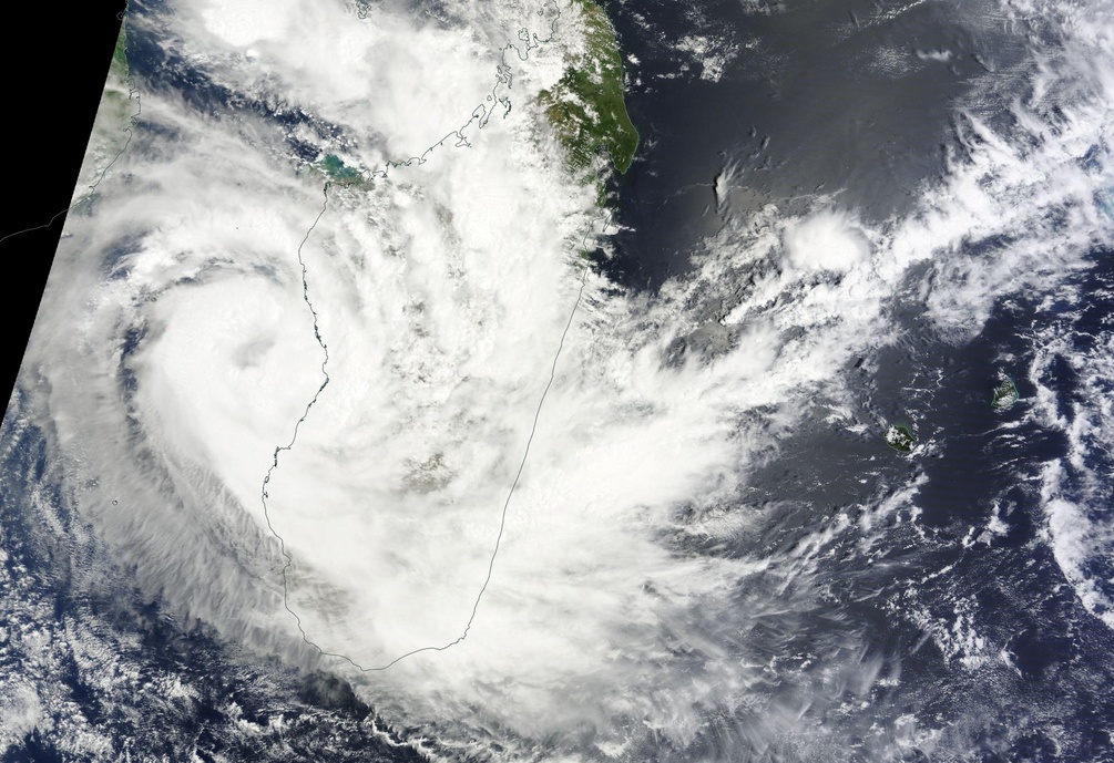
Image credit: NASA Terra/MODIS. Acquired: January 16, 2015
Latest forecast warning, issued by RSMC La Reunion at 06:00 UTC today (January 16), said the first visible and microwave imageries of this morning indicate that the low center is located more to the west that previously estimated at 00:00 UTC today. Recent improvement of the cloud pattern suggest that the wind structure is evolving towards a more typical tropical cyclone pattern.
Under the steering influence of the mid-levels near-equatorial ridge in its north, system is globally tracking southeastwards.
Chedza is located in a low sheared area and a good upper-level outflow (especially polerward) with a high oceanic heat contents.
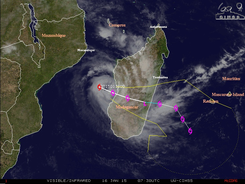
Image credit: UW-CIMSS
A climatology rhythm intensification is expected until landfall that should occur later today (Friday, January 16) or tonight over the western Madagascar coastline in the area near Morondava, the agency said.
Most of the available NWP models suggest that the mid-level circulation could resist to the crossing path over Madagascar and that the low level circulation could re-develop as the system gets back oversea on the south-east of Madagascar on Saturday, January 17.
ECMWF and GFS NWP models suggest a gradual further intensification on a east-south-eastwards track at first. On and after Monday (January 19), a mid-level trough arrives in the south and Chedza in then expected to recurve south-south-eastwards.
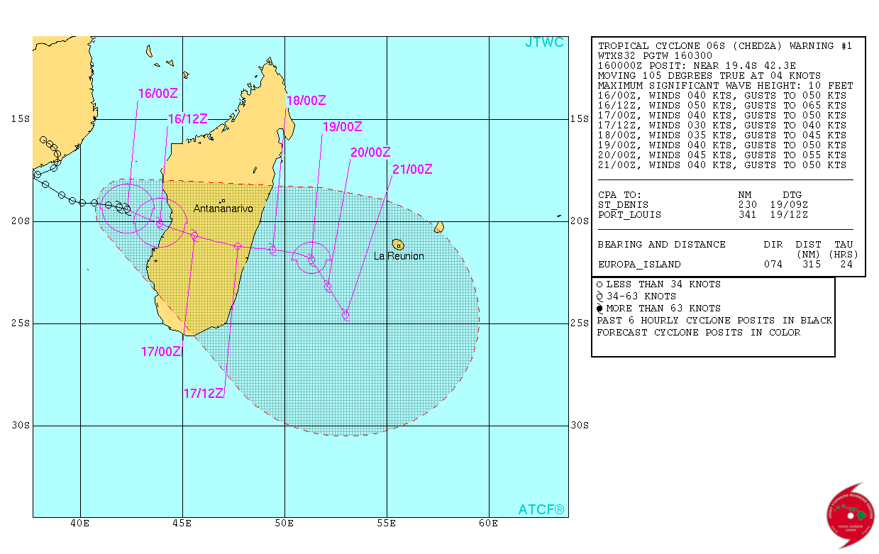
Tropical Cyclone "Chedza" forecast track by JTWC on January 16, 2015.
System's central pressure at 06:00 UTC today was 986 hPa. Its maximum average 10 minute wind speed was 74 km/h (46 mph). Chedza was moving to the SE at 9.2 km/h (5.7 mph).
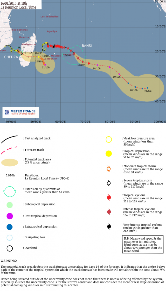
Image credit: Meteo France (RSMC La Reunion)
METEOSAT-7 infrared image below shows both Chedza (left) and Bansi (right), which was affecting Rodrigues island (population 42 000) in last couple of days.

Image credit: METEOSAT-7
At 00:00 UTC today, RSMC La Reunion said Bansi kept on intensifying within the last 6 hours and was accelerating south-eastwards. Bansi was at its closest point approach from the Rodrigues shoreline at 03:00 UTC on January 15 and is now rolling away.
At this distance, in the south-western semi-circle (the less dangerous) and despite the aforementioned intensification and very degraded weather conditions, Rodrigues island escaped to the worst. Bad conditions should however persist within the next 12 hours and start to slowly improve next night.
Bansi is expected to keep on tracking south-eastwards until Saturday, then eastwards on Sunday and to evacuate south-south-eastwards on and after Monday. This system is likely to become a post-tropical hybrid system from Sunday.
At 06:00 UTC, Bansi had central pressure of 923 hPa. Its maximum 10 minute average wind speed was 212 km/h (132 mph).
I'm a dedicated researcher, journalist, and editor at The Watchers. With over 20 years of experience in the media industry, I specialize in hard science news, focusing on extreme weather, seismic and volcanic activity, space weather, and astronomy, including near-Earth objects and planetary defense strategies. You can reach me at teo /at/ watchers.news.
Plz take this to the radios and tv channels update that 2moro some part of the following place kids must not go to school with the following reasons:: plz from M.M.Maganedisa.