
“Bansi” forecast to peak as a Category 5 hurricane equivalent
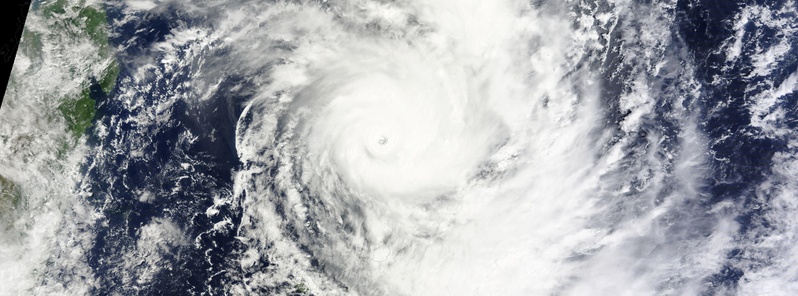
Image credit: NASA Terra/MODIS
Tropical Cyclone "Bansi" formed on January 11, 2015 north of La Reuniuon, Southern Indian Ocean, and rapidly intensified to a Category 4 hurricane on the Saffir-Simpson wind scale by early January 13.
According to RSMC La Reunion, which monitors any tropical cyclone that forms within the Southern Indian Ocean to the west of 90°, Bansi briefly reached Very Intense Tropical Cyclone status (7 out of 7) and is now Intense Tropical Cyclone again (category 6 out of 7 on South-West Indian Ocean Tropical Cyclone scale).
At 09:00 UTC today, Bansi's maximum sustained winds had increased to 240.8 km/h (149.6 mph). At the time, it was centered about 313 km (194.5 miles) north of Port Louis, Mauritius and was moving to the northeast at 7.4 km/h (4.6 mph).
Mauritius remains under a tropical cyclone warning class 2 and La Reunion Island on Yellow pre-alert.
This powerful system is creating very rough seas, with maximum wave heights to 9.1 meters (30 feet).
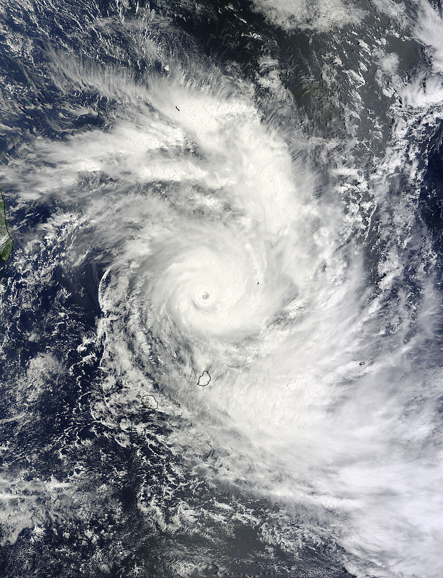
Intense Tropical Cyclone "Bansi" on January 13 at 6:25 UTC. Image credit: NASA Terra/MODIS
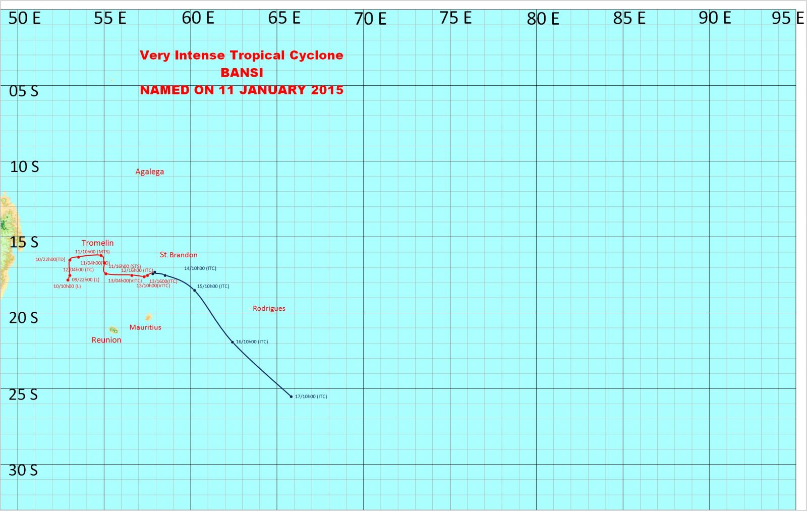
JTWC noted that slow or near quasi-stationary movement is expected over the next 36 hours due to a weak steering environment. Over that time, some intensification is likely, and the cyclone is forecast to peak as a Category 5 storm on the Saffir-Simpson Scale at 259.3 km/h (161.1 mph) before starting to weaken.
Their forecast calls for Bansi to continue moving away from Mauritius and head in an easterly direction over open waters of the Southern Indian Ocean.
.gif)
Intense Tropical Cyclone "Bansi" forecast track by JTWC on January 13, 2015.
In view of its position and intensity and its expected recurvature towards the SE tonight, the center of Bansi may come closer to Mauritius, Mauritius Meteorological Services said. Therefore, it remains a potential threat to Mauritius and the risk of experiencing cyclonic winds still exist.
The public is advised to take all necessary precautions.
The weather will remain cloudy to overcast over the whole island with intermittent showers and isolated thunderstorms. The showers will be moderate to heavy at times in places thereby causing water accumulation and flooding of river banks and other water courses. The public is advised to stay away from these places.
There will be fog patches in certain places that will reduce visibility.
Road users are advised to be extremely cautious.
Wind will blow from the eastern sector at a speed of 40 to 50 km/h (42.8 – 31 mph) with gusts reaching 90 to 100 km/h in places (55.9 – 62.1 mph).
Sea will be very rough with swells of the order of 5 to 7 meters (16 – 22 feet), breaking mainly along the North Western, Northern and Eastern coasts. Public is strongly advised not to venture at sea, the agency said.
Intense Tropical Cyclone "Bansi" forecast track by Mauritius Meteorological Services.
Satellite animations
- Storm-Centered Infrared (Meteosat 7; CIMSS)
- Storm-Centered Enhanced Infrared (Meteosat 7; CIMSS)
- Storm-Centered Water Vapor (Meteosat 7; CIMSS)
- Storm-Centered Visible (Meteosat 7; CIMSS)
- Meteosat 7 Infrared (Meteosat 7; CIMSS)
- Meteosat 7 Infrared (Color Background) (Meteosat 7; CIMSS)
- Meteosat 7 Infrared (NHC Color Enhancement) (Meteosat 7; CIMSS)
- Meteosat 7 Water Vapor (Meteosat 7; CIMSS)
- Meteosat 7 Water Vapor (Color Background) (Meteosat 7; CIMSS)
I'm a dedicated researcher, journalist, and editor at The Watchers. With over 20 years of experience in the media industry, I specialize in hard science news, focusing on extreme weather, seismic and volcanic activity, space weather, and astronomy, including near-Earth objects and planetary defense strategies. You can reach me at teo /at/ watchers.news.
Commenting rules and guidelines
We value the thoughts and opinions of our readers and welcome healthy discussions on our website. In order to maintain a respectful and positive community, we ask that all commenters follow these rules.