
Tropical Cyclone “Bansi” to intensify and pass just north of Mauritius
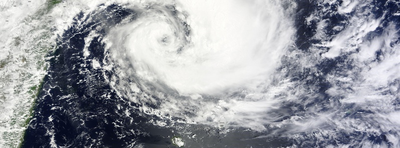
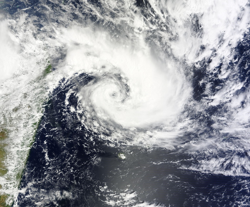
Featured image: Tropical Cyclone "Bansi" over Southern Indian Ocean. Image credit: NASA Terra/MODIS. Acquired on January 11, 2015.
Tropical Cyclone "Bansi" has formed north of La Reunion, Southern Indian Ocean, on January 11, 2015, and triggered a tropical cyclone warning class I in Mauritius, and a Yellow alert (pre-alert) in La Reunion Island. The cyclone is expected to continue moving to the ESE, toward Mauritius, while strengthening to hurricane-force (80 knots / 148 km/h / 92 mph).
At 09:00 UTC on January 11, Tropical Cyclone Bansi (formerly System 92S) was located near 16.3 south latitude and 54.7 east longitude, about 470 km (292 miles) north of St. Denis, La Reunion Island. It is slowly moving to the ESE at 5.5 km/h (3.4 mph). Maximum sustained winds were near 62 km/h (40 mph) at the time.
NASA's Terra satellite passed over Bansi at 18:50 UTC that day and captured this infrared image which shows the coldest, highest thunderstorms (red) around the western quadrant of the center.
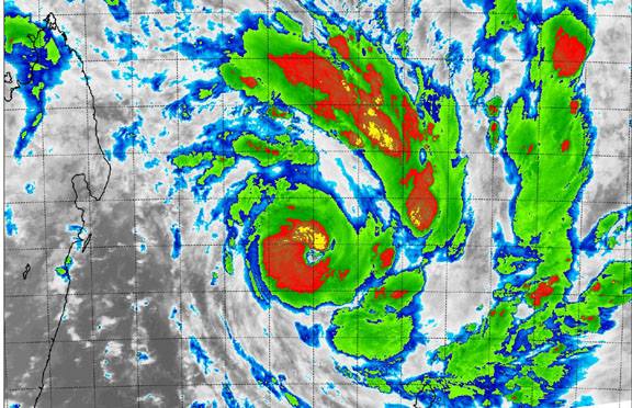
Image credit: NASA Terra/MODIS. Acquired on January 11, 2015.
At 06:00 UTC today, January 12, Tropical Cyclone "Bansi" was located about 340 km (211 miles) NW of Mauritius. It continues in SE direction at approximately 5 km/h (3.10 mph).
The environmental conditions remain favorable and further intensification is expected.
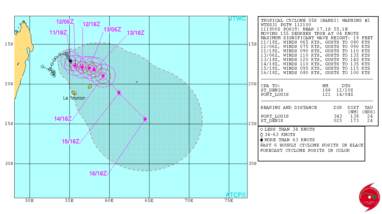
Tropical Cyclone "Bansi" forecast track by JTWC.
Mauritius Meteorological Services issued a cyclone warning class II for Mauritius today and advised public to take all necessary precautions. The agency issues class II warnings so as to allow, as far as practicable, 12 hours of daylight before the occurrence of gusts of 120 km/h (74 mph).
The weather will be cloudy to overcast over the whole island with scattered showers and isolated thunderstorms. The showers will be moderate to heavy at times in places thereby causing water accumulation and over flooding of river banks and other water courses, the agency warned.
The public is advised to stay away from these places. There will be fog patches in certain places that will reduce visibility. Road users are advised to be extremely cautious.
Wind will blow from the ENE at a speed of 40 to 50 km/h (24 – 31 mph) with gusts reaching 90 km/h tonight in places (55 mph).
Sea will become very rough with swells of the order of 3 to 4 meters (9.8 – 13.1 feet), breaking along the northern and north western coasts.
The public is strongly advised not to venture at sea.
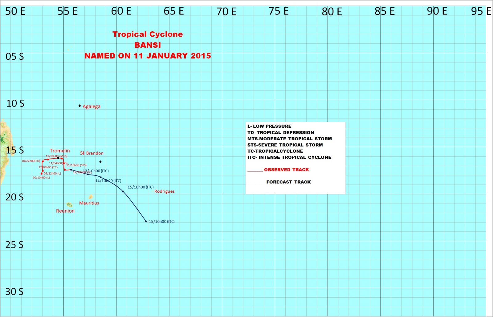
Tropical Cyclone "Bansi" forecast track by Mauritius Meteorological Services.
Tropical Cyclone "Bansi" over Southern Indian Ocean. Image credit: NASA Terra/MODIS. Acquired on January 11, 2015.
Satellite animations
- Storm-Centered Infrared (Meteosat 7; CIMSS)
- Storm-Centered Enhanced Infrared (Meteosat 7; CIMSS)
- Storm-Centered Water Vapor (Meteosat 7; CIMSS)
- Storm-Centered Visible (Meteosat 7; CIMSS)
- Meteosat 7 Infrared (Meteosat 7; CIMSS)
- Meteosat 7 Infrared (Color Background) (Meteosat 7; CIMSS)
- Meteosat 7 Infrared (NHC Color Enhancement) (Meteosat 7; CIMSS)
- Meteosat 7 Water Vapor (Meteosat 7; CIMSS)
- Meteosat 7 Water Vapor (Color Background) (Meteosat 7; CIMSS)
I'm a dedicated researcher, journalist, and editor at The Watchers. With over 20 years of experience in the media industry, I specialize in hard science news, focusing on extreme weather, seismic and volcanic activity, space weather, and astronomy, including near-Earth objects and planetary defense strategies. You can reach me at teo /at/ watchers.news.
Commenting rules and guidelines
We value the thoughts and opinions of our readers and welcome healthy discussions on our website. In order to maintain a respectful and positive community, we ask that all commenters follow these rules.