
Typhoon Rammasun about to reach super typhoon strength
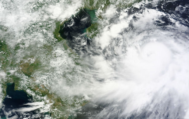
Featured image: MODIS satellite image of Typhoon Rammasun late oon July 17, 2014. (Credit: LANCE Rapid Response/MODIS)
Deadly Typhoon Rammasun (locally known as Glenda) left trail of destruction across the Philippines. According to the National Disaster Risk Reduction and Management Council of the Philippines, 40 people have been killed by the storm while more remain missing or injured.
After leaving the Philippines, and tracking across high sea surface temperatures (30-31 degrees Celsius), and low vertical wind shear, Typhoon Rammasun has quickly intensified into a Category 4 typhoon, with maximum sustained winds of 225 km/h (140 mph).
.jpg)
MTSAT-2 visible satellite image shows well-defined eye structure of Typhoon Rammasun at 23:32 UTC on July 17, 2014 (Credit: NOAA/FNMOC)
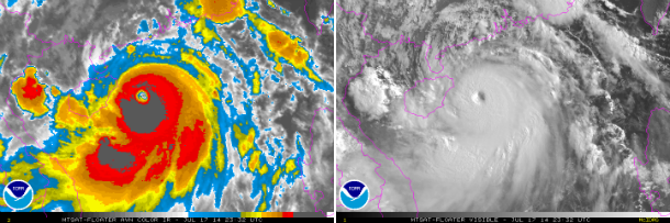
MTSAT AVN IR and visible satellite images taken at 23:32 UTC on July 17, 2014. (Credit: NOAA/MTSAT)
According to latest report by the Joint Typhoon Warning Center (JTWC), the center of Typhoon Rammasun is located approximately 232 nm south of Hong Kong, and is moving northwestward at speed of 24 km/h (15 mph). Maximum sustained winds are 222 km/h (120 mph) with gusts up to 270 km/h (145 mph). JTWC expects Rammasun to continue to strengthen before reaching land, possibly reaching super typhoon status with winds of above 240 km/h (150 mph) and gusts up to 296 km/h (184 mph) before landfall.
.gif)
Forecast track by JTWC (Credit: JTWC)
Rammasun is expected to makes landfall along the north coast of the Island near Haikou around 10:00 UTC on July 18, 2014. The China Meteorological Administration has issued a "red warning for typhoon" for the southern provinces of Hainan, Guangdong and Guangxi. Vietnam's National Center for Hydro-Meteorological Forecasting has also issued a typhoon warning for portions of northern Vietnam.
CMA is expecting up to 300 mm of rainfall in Northern Hainan and southern Guangdong. Northern Vietnam expects up to 300-400 mm of rainfall.
.jpg)
MTSAT IR satellite image taken at 22:30 UTC on July 17, 2014. (Credit: NOAA/UW-CIMSS)
.jpg)
Satellite Animations
- Storm-Centered Infrared (MTSAT2; NOAA/SSD)
- Storm-Centered Infrared (Aviation Color Enhancement) (MTSAT2; NOAA/SSD)
- Storm-Centered Water Vapor (MTSAT2; NOAA/SSD)
- Storm-Centered Visible (MTSAT2; NOAA/SSD)
- Storm-Centered Visible (Colorized) (MTSAT2; NOAA/SSD)
- Storm-Centered Infrared (MTSAT2; CIMSS)
- Storm-Centered Enhanced Infrared (MTSAT2; CIMSS)
- Storm-Centered Water Vapor (MTSAT2; CIMSS)
- Storm-Centered Visible (MTSAT2; CIMSS)
- South China Sea/West Pacific Infrared (MTSAT2; NOAA)
- South China Sea/West Pacific Enhanced Infrared (MTSAT2; NOAA)
- South China Sea/West Pacific Water Vapor (MTSAT2; NOAA)
Commenting rules and guidelines
We value the thoughts and opinions of our readers and welcome healthy discussions on our website. In order to maintain a respectful and positive community, we ask that all commenters follow these rules.