
Major explosive eruption of Sangeang Api volcano – Sunda Islands, Indonesia
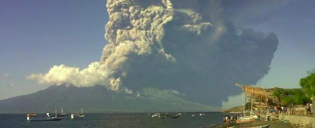
Featured image: Eruption of Sangeang Api, Indonesia, on May 30, 2014. Credit: Bang Bim via Twitter
A major explosive eruption occurred at Indonesian Sangeang Api volcano around 08:30 UTC today. A subplinian eruption column quickly rose to an estimated 15 – 20 km (50 – 65 000 ft) altitude and drifted several hundred km to the east and southeast. Aviation color code is on red.
Ash fall was reported in areas up to 30 km downwind from the volcano, VolcanoDiscovery reports.
Luckily, the island itself is largely uninhabited although visted by farmers who cultivate some land.
Evacuations were ordered within 1.5 km radius from the volcano.
Di atas pesawat menuju Labuan Bajo, salah satu tim redaksi @areamagz @johnindra, melihat lgsg letusan Gunung Sangiang pic.twitter.com/scKdtTS6nk
— AREA Magazine (@areamagz) May 30, 2014
Pray For #Sangiang #Bima #NTB [foto lasso:1) pic.twitter.com/qLDtSxaUc1
— Bang Bim (@Bambang_Bimawan) May 30, 2014
Update:
According to Darwin VAAC advisory issued May 31 at 06:30 UTC, significant eruption still continues. Aviation color code remains at red. Volcanic ash is reaching 13.7 km (45 000 ft).
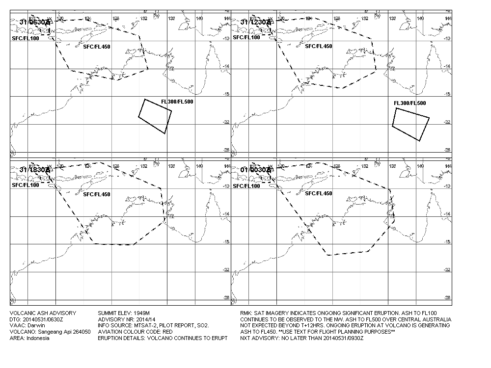
Volcanic ash graphic – Sangeang Api – May 31, 2014. Image credit: Darwin VAAC
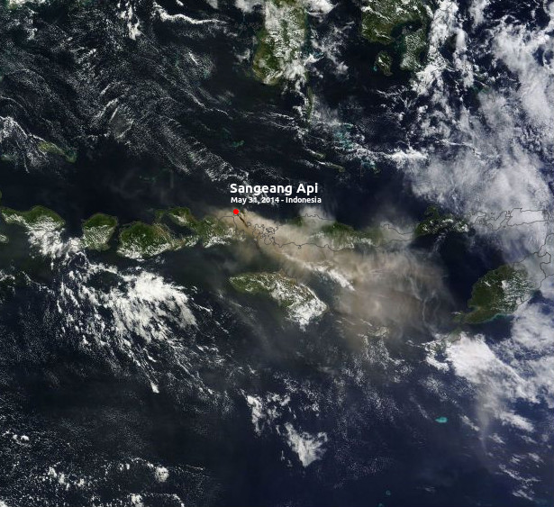
Image aquired May 31, 2014. Credit: NASA Terra / MODIS
This volcano last appeared in GVP's weekly volcanic report during the week of June 12 – 18, 2013:
CVGHM reported that during May through June 13 diffuse white plumes rose 10 m above Sangeang Api's crater. Both the lava dome and surrounding areas showed no changes since November 2012. The Alert Level had been increased to 3 (on a scale of 1-4) on May 19 due to a trend of increasing seismicity; as many as 77 shallow earthquakes and 66 deep earthquakes had been detected daily. Residents and tourists were advised to stay away from the craters within a radius of 5 km. Since then seismicity decreased; 15 shallow earthquakes and three deep earthquakes were recorded on June 13. The Alert Level was lowered to 2 on June 14. The public were advised not to approach the craters within a radius of 1.5 km.
Geologic summary
Sangeang Api volcano, one of the most active in the Lesser Sunda Islands, forms a small 13-km-wide island off the NE coast of Sumbawa Island. Two large trachybasaltic-to-tranchyandesitic volcanic cones, 1949-m-high Doro Api and 1795-m-high Doro Mantoi, were constructed in the center and on the eastern rim, respectively, of an older, largely obscured caldera. Flank vents occur on the south side of Doro Mantoi and near the northern coast. Intermittent historical eruptions have been recorded since 1512, most of them during in the 20th century. (GVP)
I'm a dedicated researcher, journalist, and editor at The Watchers. With over 20 years of experience in the media industry, I specialize in hard science news, focusing on extreme weather, seismic and volcanic activity, space weather, and astronomy, including near-Earth objects and planetary defense strategies. You can reach me at teo /at/ watchers.news.
Commenting rules and guidelines
We value the thoughts and opinions of our readers and welcome healthy discussions on our website. In order to maintain a respectful and positive community, we ask that all commenters follow these rules.