
Intense eruptive phase started at Reventador, unrest reported at Tungurahua, Ecuador
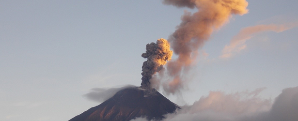
Featured image: Tungurahua on April 22, 2014. Image credit: OVT - IGEPN
A new phase of intense activity, with new lava flows, started at Ecuadorian Reventator volcano. The volcano had been in a state of intermittent strombolian explosions for the past few weeks but experienced a rapid increase in activity around 20:00 UTC on April 23, 2014.
Volcano Discovery reported that infrared images, collected by Culture Volcan, suggest a phase of lava fountaining or much stronger strombolian explosions took place. The apparent surge in lava emission also seems to have produced a new lava flow about 3 – 400 m long. This increase in activity is clearly visible in the corresponding seismic signal.

Infrared images of Reventador volcano on April 23, 2014 showing what could be a lava fountain and new lava flow. Image credit: IG EPN. Edit: Culture Volcan
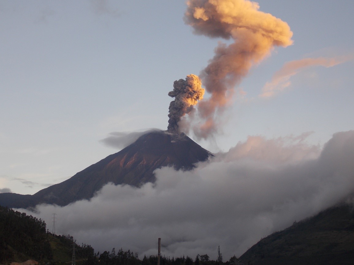
Explosion of Tungurahua on April 22 at 22:55 UTC producing a 2 km ash plume (Photo: F. Vásconez. OVT- IGEPN)
IGEPN reported on April 24 that the seismic signals at Tungurahua show persistent activity marked by numerous long period earthquakes (LP, 70 -100 events / day) indicating a significant fluid movement within the volcano.
Activity at the volcano remained at moderate-to-high levels during April 16 – 22. Although cloud cover sometimes prevented visual observations of the crater, ash plumes were observed on most days and drifted mostly WSW. Crater incandescence was often observed at night and roaring was reported from local areas.
During April 16 – 19 ashfall was reported in Mocha (25 km WNW), Tizaleo (29 km NW), Bilbao (W), Cusúa (8 km NW), Choglontus (SW), El Manzano (8 km SW), and Palictahua.
On April 17 ash plumes rose 3 km and drifted WSW. Incandescent blocks traveled 1 km down the W flank. On April 18 ash plumes rose 2 km and drifted WSW. At night Strombolian activity ejected incandescent blocks that again traveled 1 km down the W flank. Ash plumes rose 3 – 3.5 km during 19-20 April 19 – 20.
Geologic summary
Reventador
Reventador is the most frequently active of a chain of Ecuadorian volcanoes in the Cordillera Real, well east of the principal volcanic axis. The forested, dominantly andesitic Volcán El Reventador stratovolcano rises to 3562 m above the jungles of the western Amazon basin. A 4-km-wide caldera widely breached to the east was formed by edifice collapse and is partially filled by a young, unvegetated stratovolcano that rises about 1300 m above the caldera floor to a height comparable to the caldera rim. Reventador has been the source of numerous lava flows as well as explosive eruptions that were visible from Quito in historical time. Frequent lahars in this region of heavy rainfall have constructed a debris plain on the eastern floor of the caldera. The largest historical eruption at Reventador took place in 2002, producing a 17-km-high eruption column, pyroclastic flows that traveled up to 8 km, and lava flows from summit and flank vents. (GVP)
Tungurahua
Tungurahua, a steep-sided andesitic-dacitic stratovolcano that towers more than 3 km above its northern base, is one of Ecuador's most active volcanoes. Three major volcanic edifices have been sequentially constructed since the mid-Pleistocene over a basement of metamorphic rocks. Tungurahua II was built within the past 14,000 years following the collapse of the initial edifice. Tungurahua II itself collapsed about 3000 years ago and produced a large debris-avalanche deposit and a horseshoe-shaped caldera open to the west, inside which the modern glacier-capped stratovolcano (Tungurahua III) was constructed. Historical eruptions have all originated from the summit crater. They have been accompanied by strong explosions and sometimes by pyroclastic flows and lava flows that reached populated areas at the volcano's base. Prior to a long-term eruption beginning in 1999 that caused the temporary evacuation of the city of Baños at the foot of the volcano, the last major eruption had occurred from 1916 to 1918, although minor activity continued until 1925. (GVP)
I'm a dedicated researcher, journalist, and editor at The Watchers. With over 20 years of experience in the media industry, I specialize in hard science news, focusing on extreme weather, seismic and volcanic activity, space weather, and astronomy, including near-Earth objects and planetary defense strategies. You can reach me at teo /at/ watchers.news.
let's get ready to rumble…
This rapid increase of geological activities since the beginning of the year, including the increased activity at Yellowstone supervolcano is in my understanding further evidence to the heat increase at the Earth’s core. I also believe that the heat increase at the core of our planet is approaching its limit. When the limit is reached huge number of volcanoes including supervolcanoes like Yellowstone will massively erupt and the Earth will reverse its magnetic field