
Severe winter storm hits Northeast US, heavy snow warnings for the Oregon Cascades and the California Sierras
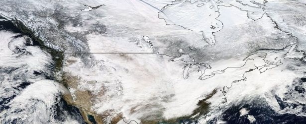
Image credit: NASA Aqua - acquired February 5, 2014
An unusually heavy winter storm set up on Monday night over southwestern Kansas peaked over Kansas City on Tuesday, February 4, bringing heavy snow and disrupting traffic. The system moved through the central United States and headed north-east into Pennsylvania, New York and New England. By Wednesday evening almost a million homes and businesses were without power. Some 5 579 US flights were delayed, and 3 208 canceled across the country.
The storm system forced the closing of many state offices and schools in Kansas, where Governor Sam Brownback declared a state of "disaster emergency." Authorities in Kansas and neighboring Missouri advised residents to stay in their homes and the National Weather Service (NWS) warned of "extremely difficult travel conditions." (Reuters)
The hardest-hit state was Pennsylvania. Gov. Tom Corbett said that late on Wednesday there were still about 586 000 customers without power, down from a peak of 849 00 earlier in the day.
Corbett said he has signed a disaster emergency proclamation, freeing up state agencies to use all available resources and personnel. "People are going to have to have some patience at this point," Corbett said, warning that an overnight refreeze could cause more problems on the roads Thursday. (AP)
Officials in New York and New Jersey warned they were starting to run short of the rock salt used by road crews to keep ice from building up on highways and local roads.
Other affected states were Maryland, Arkansas, West Virginia, Kentucky, Delaware, and Ohio.
Video courtesy News USA / ABC
According to NWS, very cold temperatures and dangerous wind chills will settle into the central U.S. for the next few days. Meanwhile, an active weather pattern will bring much needed rain and snow to parts of the western U.S. Additionally, warm, dry and windy conditions will increase fire weather concerns across south-central Alaska through the weekend.
…Snow will come to an end in the Northeast tonight as Arctic air surges down into much of the northern and eastern two-thirds of the country…
…Low pressure systems from the Pacific will bring unsettled weather into the West…
A winter storm currently bringing moderate snowfall across much of the Northeast is expected to move steadily eastward this evening and will move away from the region later tonight.
Behind the storm, a large Arctic high pressure system will then build southward from Canada and become the dominant weather system for the eastern two-thirds of the country through the end of this week.
Temperatures will once again drop well below normal.
The coldest air is expected to settle across the High Plains where temperatures of lower than 40 degrees below normal are expected through Thursday.
By Friday, the center of the Arctic high should reach the Ohio Valley. A return flow from the south will begin a moderating trend across the Plains. Over the central and southern Rockies and into Oregon, areas of light snow are expected to linger as the Arctic front becomes nearly stationary. Meanwhile, a series of Pacific low pressure systems will then approach and move onshore into the West Coast on Thursday. This will bring a period of unsettled weather across California and Oregon on Thursday and Friday, and increase the coverage of snow in the Rockies on Friday.
In the Deep South, moisture appears to begin pushing northward from the Gulf of Mexico on Thursday, bringing scattered light rain into the Gulf Coast. The rain may reach as far north as northern Georgia Thursday evening where snow may even mix in. By Friday, the rain should push farther east into the Atlantic but could continue near the Texas coast.
Valid 00:00 UTC Thursday, February 6 – 00:00 UTC Saturday, February 8, 2014
Issued: Wednesday, February 5 – 21:00 UTC
Short Range Forecast Discussion
NWS Weather Prediction Center
Latest NWS Short Range Forecast Discussion, issued 07:50 UTC today:
…Heavy snow for the Oregon Cascades and the California Sierras…
…Temperatures will be 20 to 40 degrees below average from the foothills of the Rockies to the Mississippi Valley…
Energy moving onshore over the California Coast will race to the Southern Plains by Friday evening. Onshore flow associated with the system will aid in producing coastal rain and higher elevation snow over California and Oregon through to Friday, with moderate to heavy precipitation by Friday evening. Snow will also extend into parts of the Great Basin/Central Rockies along the associated stationary front. Snow will blossom over parts of the Southwest and Southern Rockies on Friday as well.
In addition, upper-level energy over Western Texas will advance quickly eastward to off the Mid-Atlantic Coast by Friday morning. The energy will produce snow over parts of Texas on Thursday morning. Upper-level jet dynamics along the Gulf Coast will aid in producing scattered rain over parts of the Central/Eastern Gulf Coast and the Southeast Thursday evening into Friday evening. Elsewhere, cold high pressure over the Northern High Plains/Central Plains will move eastward to the Ohio Valley by Friday evening.
Valid 12:00 UTC Thursday, February 6 – 12:00 UTC Saturday, February 8, 2014
Issued: Thursday, February 6 – 07:50 UTC
Short Range Forecast Discussion
NWS Weather Prediction Center
I'm a dedicated researcher, journalist, and editor at The Watchers. With over 20 years of experience in the media industry, I specialize in hard science news, focusing on extreme weather, seismic and volcanic activity, space weather, and astronomy, including near-Earth objects and planetary defense strategies. You can reach me at teo /at/ watchers.news.
Wild Jet Stream – Mini Ice Age circulation is here to stay; CO2 warmists in desperate defeat