
New paroxysmal eruption with strombolian explosions and lava flow at Pacaya volcano, Guatemala
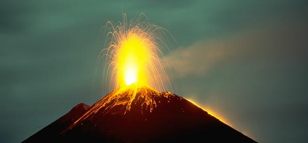
Image credit: Long-term strombolian eruptions began at Pacaya volcano in 1965 and continued for more than a quarter century. Nighttime incandescent explosions are often visible from Guatemala City, 40 km to the north. The accumulation of ejecta from frequent strombolian eruptions periodically raises the height of MacKenney cone after it has been partially destroyed by intermittent larger explosions. This November 1988 photo also shows a lava flow from a fissure on the west flank of MacKenney cone descending the right-hand skyline. Photo by Lee Siebert, 1988 (Smithsonian Institution).
Another paroxysm with strong strombolian explosions and a lava flow occurred on the evening of August 15, 2013 from the Mackenney Crater at Pacaya volcano, Guatemala. Starting at about 19:15 (local time), eruptive activity increased accompanied by volcanic tremor. Strombolian explosions ejected bombs and blocks to a height of 500 m above the crater and showered the outer flanks.
VAAC Washington issued a bulletin but was unable to identify the height of the ash plume from satellite data. Ash fall was reported from nearby villages such as El Rodeo and El Patrocinio. At the height of the eruption, a lava flow issued from the west flank and reached a distance of 500 m (VD).
As a safety measure, 32 people from the village of San Francisco de Sales on the SW base of the volcano were evacuated to shelters in San Vicente Pacaya on the northwest side.
After about 2 hours, activity started to wane again.
INSIVUMEH reported that during August 7 – 8 white vapor plumes rose 200 m above Pacaya and drifted E. On August 9 seismicity increased, and strombolian explosions ejected tephra 200 m above MacKenney Crater and onto the flanks, 400 m away from crater. The next day the number and magnitudes of explosions increased, and seismic signals indicating fluid movement were recorded.
Tephra was again ejected 400 m away from MacKenney Crater, causing small avalanches of volcanic material on the flanks. On 12 August fumarolic plumes rose 50 m. Cloud cover prevented observations of the crater on August 13; however, the seismic network recorded a few gas explosions and tremor.
I'm a dedicated researcher, journalist, and editor at The Watchers. With over 20 years of experience in the media industry, I specialize in hard science news, focusing on extreme weather, seismic and volcanic activity, space weather, and astronomy, including near-Earth objects and planetary defense strategies. You can reach me at teo /at/ watchers.news.
Commenting rules and guidelines
We value the thoughts and opinions of our readers and welcome healthy discussions on our website. In order to maintain a respectful and positive community, we ask that all commenters follow these rules.