
M 5.6 earthquake hit Philippines, landslides and new activity at Mayon volcano

Image credit: Mayon volcano (Photo by Kurt Fredrickson/Smithsonian Institution)
According to latest bulletin by Philippine Institute for Volcanology and Seismology (PHIVOLCS), Mayon volcano’s seismic network recorded one rock fall related event during the past 24-hour observation period. Moderate emission of white steam plumes was observed, drifting northwest and west-southwest. The persistence of weak glow may denote heating of the atmosphere above the crater due to a steady emission of magmatic gas.
Sulfur dioxide (SO2) emission on June 01, 2013 was measured at an average of 290 tonnes per day, but has varied between 55 and 388 tonnes per day (normal level is up to 500 tonnes per day.
Mayon Volcano’s alert status remains at Alert Level 1. Although this means that presently no magmatic eruption is imminent, it is strongly advised that the public refrain from entering the 6-kilometer radius Permanent Danger Zone (PDZ) due to the perennial life-threatening dangers of rockfalls, landslides/avalanches at the middle to upper slope, sudden ash puffs and steam-driven or phreatic eruptions from the summit.
.jpg)
Mayon’s frequent historical eruptions, recorded since 1616, have typically included powerful explosive activity accompanied by pyroclastic flows, mudflows, and lava flows that descended to the lower flanks of the volcano.
(Photo by Kurt Fredrickson/Smithsonian Institution)
Active stream/river channels and those identified as perennially lahar-prone areas on all sectors of the volcano should also be avoided especially during extreme weather conditions when there is heavy and prolonged rainfall.
Seismicity has been markedly low. Ground deformation survey (precise leveling) on the third week of May 2013 showed slight inflation of the edifice compared to February 2012, with the volcano still slightly inflated compared to January 2010 baselines.
Last phreatic eruption was observed on May 7, 2013 when 5 people lost their lives.
Meantime, on June 1, 2013 strong and shallow M 5.6 (USGS) hit Mindanao Island of Philippines. The epicenter was located 14 km NE of President Roxas at depth of 18km. PHIVOLCS registered M 5.7 only 5km deep.
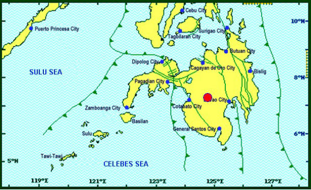
Strong M 5.6 occurred near Carmen, North Cotabato (Credit:: PHIVOLCS)
GMA News reports that the quake caused a landslide in Barangay Kimadsil in the town of Carmen. A house in the same barangay also sustained unspecified damage. Cracks developed in the bridge that connects Kimadsil to the neighboring village, prompting residents to keep trucks and other heavy vehicles from using it.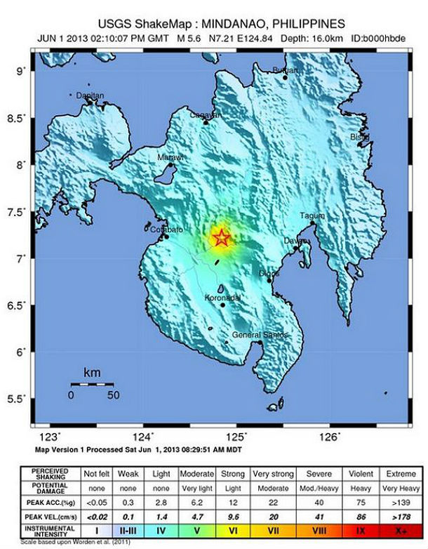
USGS Shake map
The Philippine archipelago is located in the Pacific "Ring of Fire," where earthquakes and volcanic activity are common. The Philippines sits on a unique tectonic setting ideal to volcano formation. The archipelago is surrounded by subducting plates as manifested by the trenches that are related to volcano formation. Philippines have 23 active volcanoes.
Source: PHIVOLCS
Commenting rules and guidelines
We value the thoughts and opinions of our readers and welcome healthy discussions on our website. In order to maintain a respectful and positive community, we ask that all commenters follow these rules.