
Active volcanoes in the world – May 22 – May 28, 2013
Image credit: TW
This week, 7 volcanoes were noticed to have new activity, whereas ongoing activity was reported for 11 volcanoes. This report covers active volcanoes in the world recorded from May 22 – May 28, 2013 based on Smithsonian/USGS criteria.
New activity/unrest: | Chirinkotan, Kuril Islands | Cleveland, Chuginadak Island | Copahue, Central Chile-Argentina border | Gamkonora, Halmahera | Pavlof, Alaska Peninsula | Popocatépetl, México | Turrialba, Costa Rica
Ongoing activity: | Bagana, Bougainville | Karymsky, Eastern Kamchatka (Russia) | Kilauea, Hawaii (USA) | Kizimen, Eastern Kamchatka (Russia) | Pacaya, Guatemala | Paluweh, Lesser Sunda Islands (Indonesia) | Sakura-jima, Kyushu | Sangay, Ecuador | Shiveluch, Central Kamchatka (Russia) | Tolbachik, Central Kamchatka (Russia) | Yasur, Vanuatu (SW Pacific)
Global Volcanism Program and the US Geological Survey's Volcano Hazards Program. Updated by 2300 UTC every Wednesday, notices of volcanic activity posted on these pages are preliminary and subject to change as events are studied in more detail. This is not a comprehensive list of all of Earth's volcanoes erupting during the week, but rather a summary of activity at volcanoes that meet criteria discussed in detail in the "Criteria and Disclaimers" section. Carefully reviewed, detailed reports on various volcanoes are published monthly in the Bulletin of the Global Volcanism Network.
New activity/unrest
CHIRINKOTAN, Kuril Islands
48.980°N, 153.480°E; summit elev. 724 m

The plume of Chirinkotan volcano on May 24, 2013 (NASA/MODIS via Blog Culture Volcan).
SVERT reported that steam and gas activity at Chirinkotan was observed in satellite imagery during 24-25 May.
Geologic summary: The small, mostly unvegetated 3-km-wide island of Chirinkotan occupies the far end of an E-W-trending volcanic chain that extends nearly 50 km west of the central part of the main Kuril Islands arc. Chirinkotan is the emergent summit of a volcano that rises 3000 m from the floor of the Kuril Basin. A small 1-km-wide caldera about 300-400 m deep is open to the SE. Lava flows from a cone within the breached crater reached the north shore of the island. Historical eruptions have been recorded at Chirinkotan since the 18th century. Fresh lava flows also descended the SE flank of Chirinkotan during an eruption in the 1880s that was observed by the English fur trader Captain Snow.
CLEVELAND, Chuginadak Island
52.825°N, 169.944°W; summit elev. 1730 m
AVO reported that during 22-23 May elevated surface temperatures over Cleveland were observed in satellite images. Clouds obscured views during 24-26 May. Slightly elevated surface temperatures, consistent with a cooling lava flow, were observed in several satellite images during 26-28 May. The Volcanic Alert Level remained at Watch and the Aviation Color Code remained at Orange.
Geologic summary: Symmetrical Mount Cleveland stratovolcano is situated at the western end of the uninhabited dumbbell-shaped Chuginadak Island in the east-central Aleutians. The 1,730-m-high stratovolcano is the highest of the Islands of Four Mountains group and is one of the most active in the Aleutians. Numerous large lava flows descend its flanks. It is possible that some 18th to 19th century eruptions attributed to Carlisle (a volcano located across the Carlisle Pass Strait to the NW) should be ascribed to Cleveland. In 1944 Cleveland produced the only known fatality from an Aleutian eruption. Recent eruptions from Mt. Cleveland have been characterized by short-lived explosive ash emissions, at times accompanied by lava fountaining and lava flows down the flanks.
COPAHUE, Central Chile-Argentina border
37.85°S, 71.17°W; summit elev. 2997 m
Steam-ash plume from Copahue on 24 May (SERNAGEOMIN webcam)
OVDAS-SERNAGEOMIN reported that a gradual increase of seismicity at Copahue had been detected since 15 May. A camera recorded periodic small explosions and corresponding ash emissions, along with nighttime incandescence. On 19 May satellite images detected increased sulfur dioxide emissions, which produced a plume that rose 300 m above the crater and drifted SE. Images from 20 and 22 May showed large plumes drifting 100 km SE that appeared translucent gray, suggesting a significant presence of volcanic gases. On 23 May the Alert Level was raised to Orange.
On 24 May cameras recorded white plumes that mostly rose 250-400 m; at 1900 a plume rose 1.9 km, and another drifted NE. Seismicity increased sharply during 24-25 May. The seismic network detected 8,556 low-magnitude earthquakes with an average of 356 events per hour, and a gap of a few seconds between events. Seismicity increased again during 25-26 May, with an average of 455 events per hour, and then decreased to 269 events per hour during 26-27 May. An explosion on 26 May generated crater incandescence and a plume that rose 400 m. Weather conditions often prevented views during 25-27 May.
On 27 May OVDAS-SERNAGEOMIN noted that the intensity and type of seismicity observed in recent days, in conjunction with the deformation data, suggested the rise of a magmatic body to shallow depths. The Alert Level was raised to Red. According to ONEMI, the government ordered a precautionary evacuation of the 2,440 people living within a radius of 25 km. During 27-28 May seismic signals were detected at an average rate of 130 events per hour. Cloud cover prevented visual observations. ONEMI noted that 44 people had evacuated by 28 May.
Geologic summary: Volcán Copahue is an elongated composite cone constructed along the Chile-Argentina border within the 6.5 x 8.5 km wide Trapa-Trapa caldera that formed between 0.6 and 0.4 million years ago near the NW margin of the 20 x 15 km Pliocene Caviahue (Del Agrio) caldera. The eastern summit crater, part of a 2-km-long, ENE-WSW line of nine craters, contains a briny, acidic 300-m-wide crater lake (also referred to as El Agrio or Del Agrio) and displays intense fumarolic activity. Acidic hot springs occur below the eastern outlet of the crater lake, contributing to the acidity of the Río Agrio, and another geothermal zone is located within Caviahue caldera about 7 km NE of the summit. Infrequent mild-to-moderate explosive eruptions have been recorded at Copahue since the 18th century. Twentieth-century eruptions from the crater lake have ejected pyroclastic rocks and chilled liquid sulfur fragments.
GAMKONORA, Halmahera
1.38°N, 127.53°E; summit elev. 1635 m
CVGHM reported that a phreatic eruption at Gamkonora on 23 January was preceded by increased seismicity. Some types of seismic signals increased during March-April while others decreased. On 24 May seismicity indicative of shallow magma movement increased and diffuse white plumes rose 100-300 above the crater. During 25-27 May dense white-to-gray plumes rose 200-500 m above the crater. On 27 May the Alert Level was raised to 3 (on a scale of 1-4). Residents and tourists were asked not to venture near the crater within a radius of 3 km.
Geologic summary: The shifting of eruption centers on Gamkonora, at 1635 m the highest peak of Halmahera, has produced an elongated series of summit craters along a N-S trending rift. Youthful-looking lava flows originate near the cones of Gunung Alon and Popolojo, south of Gamkonora. Since its first recorded eruption in the 16th century, Gamkonora has typically produced small-to-moderate explosive eruptions. Its largest historical eruption, in 1673, was accompanied by tsunamis that inundated villages.
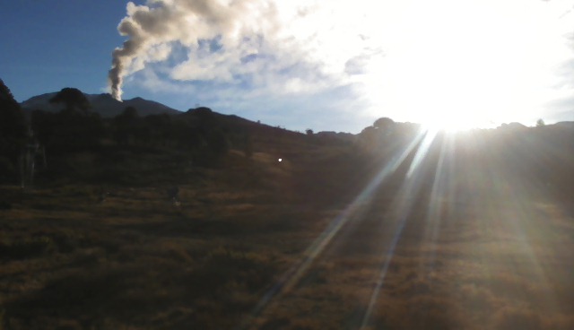
PAVLOF, Alaska Peninsula
55.42°N, 161.887°W; summit elev. 2519 m
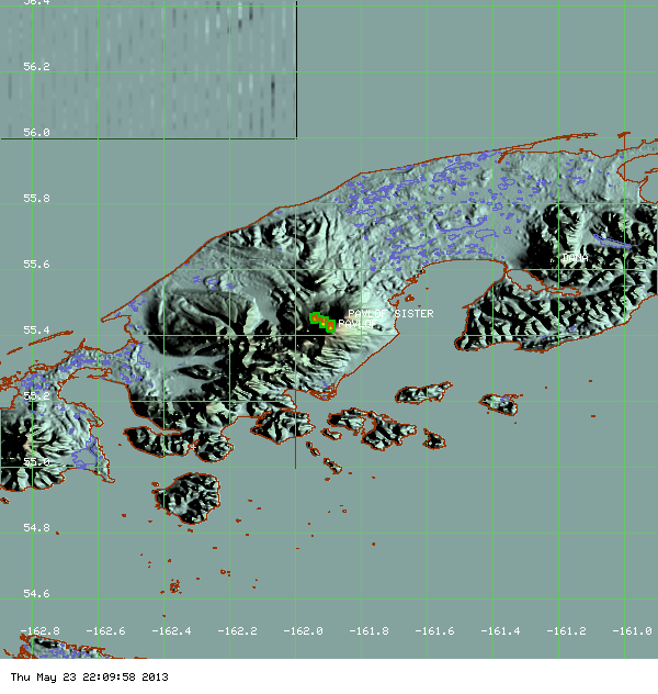
MODIS hot spot data for Pavlov volcano, on May 23, 2013 (ModVolc, Univ. Hawaii)
AVO reported that seismic tremor at Pavlof markedly declined around 1100 on 21 May, and was followed through 23 May by the detection of small discrete events, likely indicative of small explosions, by pressure sensors. Although cloud cover prevented satellite observations, elevated surface temperatures at the vent were detected. On 22 May both a pilot report and photographs indicated weak steam-and-gas emissions containing little to no ash.
The eruption continued but at a lower level during 24-26 May. Neither evidence of elevated surface temperatures nor a plume were observed in partly clear satellite images during 24-25 and 27 May. Clouds obscured views on 26 May. The Volcanic Alert Level was lowered to Advisory and the Aviation Color Code was lowered to Yellow on 28 May.
Geologic summary: The most active volcano of the Aleutian arc, Pavlof is a 2519-m-high Holocene stratovolcano that was constructed along a line of vents extending NE from the Emmons Lake caldera. Pavlof and its twin volcano to the NE, 2142-m-high Pavlof Sister, form a dramatic pair of symmetrical, glacier-covered stratovolcanoes that tower above Pavlof and Volcano bays. A third cone, Little Pavolf, is a smaller volcano on the SW flank of Pavlof volcano, near the rim of Emmons Lake caldera. Unlike Pavlof Sister, Pavlof has been frequently active in historical time, typically producing strombolian to vulcanian explosive eruptions from the summit vents and occasional lava flows. The active vents lie near the summit on the north and east sides. The largest historical eruption of Pavlof took place in 1911, at the end of a 5-year-long eruptive episode; a fissure opened on the northern flank of the volcano, ejecting large blocks and issuing lava flows.
POPOCATEPETL, México
19.023°N, 98.622°W; summit elev. 5426 m

Explosion from Popocatépetl on May 28, 2013
CENAPRED reported that during 22-28 May seismicity at Popocatépetl indicated continuing gas-and-steam emissions that contained variable amounts of ash; cloud cover occasionally prevented observations, especially during 26-27 May. Incandescence from the crater was often observed at night.
On 22 May an ash plume rose 2 km above the crater and drifted NE. Periods of tremor were accompanied by emissions of steam, gas, and sometimes ash. Two plumes rose 1.3 km and drifted W. Overnight incandescent tephra was ejected 300 m above the crater and rolled down the flanks. Tremor amplitude increased on 23 May, and ash emissions drifted SE, S, and SW. An explosion at 0254 ejected large fragments that landed 1.5 km away from the crater. At 1240 an explosion generated a gas-and-ash plume that rose 2.5 km. Later that day tremor decreased; periods of tremor continued to be detected through 27 May, accompanied by emissions of steam, gas and variable amounts of ash that rose 500-900 m and drifted SW.
On 25 May incandescent tephra were ejected onto the highest parts of the N and NE flanks, and a gas-and-ash plume rose 2 km. An explosion at 0547 ejected incandescent tephra 1.5 km onto the NNE flank. An explosion at 1040 on 26 May generated an ash plume that rose 2 km. A small explosion was detected at 1228. On 28 May an explosion at 0503 produced an ash plume that rose more than 2 km and drifted SW, and ejected incandescent tephra 1.5 km onto the NE flank. The Alert Level remained at Yellow, Phase Three.
Geologic summary: Popocatépetl, whose name is the Aztec word for smoking mountain, towers to 5,426 m 70 km SE of Mexico City and is North America's second-highest volcano. Frequent historical eruptions have been recorded since the beginning of the Spanish colonial era. A small eruption on 21 December 1994 ended five decades of quiescence. Since 1996 small lava domes have incrementally been constructed within the summit crater and destroyed by explosive eruptions. Intermittent small-to-moderate gas-and-ash eruptions have continued, occasionally producing ashfall in neighboring towns and villages.
TURRIALBA, Costa Rica
10.025°N, 83.767°W; summit elev. 3340 m
OVSICORI-UNA reported that an eruption from Turrialba's West Crater on 21 May was preceded by seismic activity characterized by more than 150 volcanic earthquakes per day since 18 April.
Increased gas emissions were detected on 20 May, producing a sky-blue plume visible from nearby areas. Hybrid earthquakes also increased and became numerous at 0452 on 21 May. Continuous harmonic tremor followed and then increased at 0720. Eruptions from West Crater occurred at 0830 and after 1100 from two vents which opened in January 2010 (Boca 2010, on the W wall) and January 2012 (Boca 2012, on the E wall). The eruptions generated ash plumes that rose more than 500 m; ashfall was reported in the area of Picada (N), and in San José (35 km WSW) and Heredia (38 km W) of Ipís de Guadalupe, Goicoechea (28 km WSW), la Fazio, Zetillal (43 km W), San Isidro-San Pedro de Coronado, and San Luis de Santo Domingo (28 km W). At around 1200 ash emissions ceased and seismicity decreased.
Geologic summary: Turrialba, the easternmost of Costa Rica's Holocene volcanoes, is a large vegetated basaltic-to-dacitic stratovolcano located across a broad saddle NE of Irazú volcano overlooking the city of Cartago. The massive 3340-m-high Turrialba is exceeded in height only by Irazú, covers an area of 500 sq km, and is one of Costa Rica's most voluminous volcanoes. Three well-defined craters occur at the upper SW end of a broad 800 x 2200 m wide summit depression that is breached to the NE. Most activity at Turrialba originated from the summit vent complex, but two pyroclastic cones are located on the SW flank. Five major explosive eruptions have occurred at Turrialba during the past 3500 years. Turrialba has been quiescent since a series of explosive eruptions during the 19th century that were sometimes accompanied by pyroclastic flows. Fumarolic activity continues at the central and SW summit craters.
Ongoing activity
BAGANA, Bougainville
6.140°S, 155.195°E; summit elev. 1750 m
Based on analyses of satellite imagery and wind data, the Darwin VAAC reported that on 24 May an ash plume from Bagana rose to an altitude of 2.1 km (7,000 ft) a.s.l. and drifted over 35 km NW and N.
Geologic summary: Bagana volcano, occupying a remote portion of central Bougainville Island, is one of Melanesia's youngest and most active volcanoes. Bagana is a massive symmetrical lava cone largely constructed by an accumulation of viscous andesitic lava flows. The entire lava cone could have been constructed in about 300 years at its present rate of lava production. Eruptive activity at Bagana is characterized by non-explosive effusion of viscous lava that maintains a small lava dome in the summit crater, although explosive activity occasionally producing pyroclastic flows also occurs. Lava flows form dramatic, freshly preserved tongue-shaped lobes up to 50-m-thick with prominent levees that descend the volcano's flanks on all sides.
KARYMSKY, Eastern Kamchatka (Russia)
54.05°N, 159.45°E; summit elev. 1536 m
KVERT reported that satellite data showed a thermal anomaly on Karymsky during 21-22 May. Technical problems prevented seismic data collection during 17-24 May. The Aviation Color Code remained at Orange.
Geologic summary: Karymsky, the most active volcano of Kamchatka's eastern volcanic zone, is a symmetrical stratovolcano constructed within a 5-km-wide caldera that formed about 7,600-7,700 radiocarbon years ago. Construction of the Karymsky stratovolcano began about 2,000 years later. The latest eruptive period began about 500 years ago, following a 2,300-year quiescence. Much of the cone is mantled by lava flows less than 200 years old. Historical eruptions have been Vulcanian or Vulcanian-Strombolian with moderate explosive activity and occasional lava flows from the summit crater. Most seismicity preceding Karymsky eruptions has originated beneath Akademia Nauk caldera, which is located immediately S of Karymsky volcano and erupted simultaneously with Karymsky in 1996.
KILAUEA, Hawaii (USA)
19.421°N, 155.287°W; summit elev. 1222 m
During 22-28 May HVO reported that the circulating lava lake occasionally rose and fell in the deep pit within Kilauea's Halema'uma'u Crater. The plume from the vent continued to deposit variable amounts of ash, spatter, and Pele's hair onto nearby areas.
At Pu'u 'O'o Crater, glow emanated from three spatter cones and a small lava pond on the E part of the crater floor. The Kahauale’a II lava flows traveled N from the base of Pu'u 'O'o cone. The most distal front of the flow was 1.8 km from its source at a spatter cone on the NE edge of Pu'u 'O'o's crater floor. At 0740 on 26 May lava began to spill from the N side of the NE spatter cone, feeding a new breakout on the N flank of Pu'u 'O'o.
Peace Day activity, fed by lava tubes extending from Pu'u 'O'o, consisted of some breakout activity on the pali and coastal plain, but mainly flows entering the ocean at locations inside and outside the National Park boundary.
Geologic summary: Kilauea, one of five coalescing volcanoes that comprise the island of Hawaii, is one of the world's most active volcanoes. Eruptions at Kilauea originate primarily from the summit caldera or along one of the lengthy E and SW rift zones that extend from the caldera to the sea. About 90% of the surface of Kilauea is formed of lava flows less than about 1,100 years old; 70% of the volcano's surface is younger than 600 years. A long-term eruption from the East rift zone that began in 1983 has produced lava flows covering more than 100 sq km, destroying nearly 200 houses and adding new coastline to the island.
KIZIMEN, Eastern Kamchatka (Russia)
55.130°N, 160.32°E; summit elev. 2376 m
KVERT reported that during 17-24 May moderate seismic activity continued at Kizimen. Video and satellite data showed that lava continued to extrude from the summit, producing incandescence, strong gas-and-steam activity, and hot avalanches on the W and E flanks. A thermal anomaly was detected daily in satellite images. The Aviation Color Code remained at Orange.
Geologic summary: Kizimen is an isolated, conical stratovolcano that is morphologically similar to Mount St. Helens prior to its 1980 eruption. The summit of Kizimen consists of overlapping lava domes, and blocky lava flows descend the flanks of the volcano, which is the westernmost of a volcanic chain north of Kronotsky volcano. The 2,376-m-high Kizimen was formed during four eruptive cycles beginning about 12,000 years ago and lasting 2,000-3,500 years. The largest eruptions took place about 10,000 and 8300-8400 years ago, and three periods of longterm lava-dome growth have occurred. The latest eruptive cycle began about 3,000 years ago with a large explosion and was followed by lava-dome growth lasting intermittently about 1,000 years. An explosive eruption about 1,100 years ago produced a lateral blast and created a 1.0 x 0.7 km wide crater breached to the NE, inside which a small lava dome (the fourth at Kizimen) has grown. A single explosive eruption, during 1927-28, has been recorded in historical time.
PACAYA, Guatemala
14.381°N, 90.601°W; summit elev. 2552 m
INSIVUMEH reported that during 22-23 May weak Strombolian activity at Pacaya's MacKenney cone was detected by the seismic network. On 24 May white plumes rose 600 m and drifted S. In a special bulletin on 25 May, INSIVUMEH noted that the eruptive pattern had changed during the previous few days. Explosions were more continuous and energetic, and were detected 3-5 minutes apart. Explosions ejected bombs and generated rumbles heard 4 km away. Cloud cover mostly prevented views on 27 May, but blue gas plumes were observed. Occasional weak glow from the crater was observed on 28 May.
Geologic summary: Eruptions from Pacaya, one of Guatemala's most active volcanoes, are frequently visible from Guatemala City, the nation's capital. Pacaya is a complex volcano constructed on the southern rim of the 14 x 16 km Pleistocene Amatitlan caldera. A cluster of dacitic lava domes occupies the caldera floor. The Pacaya massif includes the Cerro Grande lava dome and a younger volcano to the SW. Collapse of Pacaya volcano about 1,100 years ago produced a debris-avalanche deposit that extends 25 km onto the Pacific coastal plain and left an arcuate somma rim inside which the modern Pacaya volcano (MacKenney cone) grew. During the past several decades, activity at Pacaya has consisted of frequent Strombolian eruptions with intermittent lava flow extrusion on the flanks of MacKenney cone, punctuated by occasional larger explosive eruptions.
PALUWEH, Lesser Sunda Islands (Indonesia)
8.32°S, 121.708°E; summit elev. 875 m
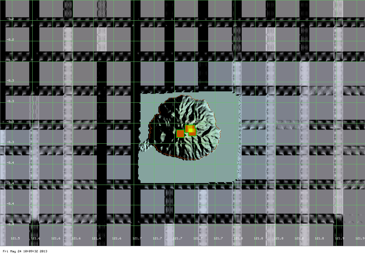
MODIS hot spot data (May 24, 2013) for Paluweh volcano (ModVolc, Univ. Hawaii)
Based on analyses of satellite imagery and wind data, the Darwin VAAC reported that during 21-22 and 24 May ash plumes from Paluweh rose to altitudes of 2.1-3 km (7,000-10,000 ft) a.s.l. and drifted 25-55 km NW, W, and E.
Geologic summary: Paluweh volcano, also known as Rokatenda, forms the 8-km-wide island of Paluweh N of the volcanic arc that cuts across Flores Island. Although the volcano rises about 3,000 m above the sea floor, its summit reaches only 875 m above sea level. The broad irregular summit region contains overlapping craters up to 900 m wide and several lava domes. Several flank vents occur along a NW-trending fissure. The largest historical eruption of Paluweh occurred in 1928, when a strong explosive eruption was accompanied by landslide-induced tsunamis and lava-dome emplacement.
SAKURA-JIMA, Kyushu
31.585°N, 130.657°E; summit elev. 1117 m
JMA reported that during 20-24 May Sakura-jima's Showa Crater had eight explosions, ejecting tephra that fell at most 1.3 km from the crater. Crater incandescence was occasionally detected at night. Based on information from JMA, the Tokyo VAAC reported that during 23-26 May explosions produced plumes that rose to altitudes of 1.8-2.4 km (6,000-8,000 ft) a.s.l. and drifted E, SW, and W. On 24 May a pilot observed an ash plume that rose to an altitude of 3 km (10,000 ft) a.s.l.
Geologic summary: Sakura-jima, one of Japan's most active volcanoes, is a post-caldera cone of the Aira caldera at the northern half of Kagoshima Bay. Eruption of the voluminous Ito pyroclastic flow was associated with the formation of the 17 x 23-km-wide Aira caldera about 22,000 years ago. The construction of Sakura-jima began about 13,000 years ago and built an island that was finally joined to the Osumi Peninsula during the major explosive and effusive eruption of 1914. Activity at the Kita-dake summit cone ended about 4,850 years ago, after which eruptions took place at Minami-dake. Frequent historical eruptions, recorded since the 8th century, have deposited ash on Kagoshima, one of Kyushu's largest cities, located across Kagoshima Bay only 8 km from the summit. The largest historical eruption took place during 1471-76.
SANGAY, Ecuador
2.002°S, 78.341°W; summit elev. 5230 m
Based on a pilot report, the Washington VAAC reported that on 23 May an ash plume from Sangay drifted W at an altitude of 7.6 km (25,000 ft) a.s.l. Weather clouds prevented satellite image views of the plume.
Geologic summary: The isolated Sangay volcano, located E of the Andean crest, is the southernmost of Ecuador's volcanoes, and its most active. It has been in frequent eruption for the past several centuries. The steep-sided, 5,230-m-high glacier-covered volcano grew within horseshoe-shaped calderas of two previous edifices, which were destroyed by collapse to the E, producing large debris avalanches that reached the Amazonian lowlands. The modern edifice dates back to at least 14,000 years ago. Sangay towers above the tropical jungle on the E side; on the other sides flat plains of ash from the volcano have been sculpted by heavy rains into steep-walled canyons up to 600 m deep. The earliest report of an historical eruption was in 1628. More or less continuous eruptions were reported from 1728 until 1916, and again from 1934 to the present. The more or less constant eruptive activity has caused frequent changes to the morphology of the summit crater complex.
SHIVELUCH, Central Kamchatka (Russia)
56.653°N, 161.360°E; summit elev. 3283 m
Based on visual observations and analyses of satellite data, KVERT reported that during 17-24 May a viscous lava flow effused on the N flank of Shiveluch's lava dome, accompanied by hot avalanches, incandescence, and fumarolic activity. Satellite imagery showed a daily thermal anomaly on the lava dome. The Aviation Color Code remained at Orange.
Geologic summary: The high, isolated massif of Shiveluch volcano (also spelled Sheveluch) rises above the lowlands NNE of the Kliuchevskaya volcano group and forms one of Kamchatka's largest and most active volcanoes. The currently active Molodoy Shiveluch lava-dome complex was constructed during the Holocene within a large breached caldera formed by collapse of the massive late-Pleistocene Strary Shiveluch volcano. At least 60 large eruptions of Shiveluch have occurred during the Holocene, making it the most vigorous andesitic volcano of the Kuril-Kamchatka arc. Frequent collapses of lava-dome complexes, most recently in 1964, have produced large debris avalanches whose deposits cover much of the floor of the breached caldera. Intermittent explosive eruptions began in the 1990s from a new lava dome that began growing in 1980. The largest historical eruptions from Shiveluch occurred in 1854 and 1964.
TOLBACHIK, Central Kamchatka (Russia)
55.830°N, 160.330°E; summit elev. 3682 m
KVERT reported that the S fissure along the W side of Tolbachinsky Dol, a lava plateau on the SW side of Tolbachik, continued to produce very fluid lava flows during 17-24 May that traveled to the W, S, and E sides of the plateau. Cinder cones continued to grow along the S fissure and weak gas-and-steam plumes were observed. A large thermal anomaly on the N part of Tolbachinsky Dol was visible daily in satellite imagery. The Aviation Color Code remained at Orange.
Geologic summary: The massive Tolbachik basaltic volcano is located at the southern end of the dominantly andesitic Kliuchevskaya volcano group. The Tolbachik massif is composed of two overlapping, but morphologically dissimilar volcanoes. The flat-topped Plosky Tolbachik shield volcano with its nested Holocene Hawaiian-type calderas up to 3 km in diameter is located east of the older and higher sharp-topped Ostry Tolbachik stratovolcano. The summit caldera at Plosky Tolbachik was formed in association with major lava effusion about 6500 years ago and simultaneously with a major southward-directed sector collapse of Ostry Tolbachik volcano. Lengthy rift zones extending NE and SSW of the volcano have erupted voluminous basaltic lava flows during the Holocene, with activity during the past two thousand years being confined to the narrow axial zone of the rifts. The 1975-76 eruption originating from the SSW-flank fissure system and the summit was the largest historical basaltic eruption in Kamchatka.
YASUR, Vanuatu (SW Pacific)
19.53°S, 169.442°E; summit elev. 361 m

Steam and ash plume from Yasur (5,8,23,24 May, 2013) and hazard map of Yasur volcano and explanation of status levels (Geohazards)
On 28 May, the Vanuatu Geohazards Observatory reported that activity at Yasur continued to increase slightly, and bombs fell around the summit area, the tourist walk, and the parking area. Ash venting and dense white plumes from the crater were observed. Photos included in the report showed ash emissions and ashfall on 5 and 8 May, and dense white plumes on 23 and 24 May. The Alert Level remained at 2 (on a scale of 0-4).
Geologic summary: Yasur, the best-known and most frequently visited of the Vanuatu volcanoes, has been in more-or-less continuous Strombolian and vulcanian activity since Captain Cook observed ash eruptions in 1774. This style of activity may have continued for the past 800 years. Yasur is a mostly unvegetated pyroclastic cone with a nearly circular, 400-m-wide summit crater. Yasur is largely contained within the small Yenkahe caldera in SE Tanna Island. It is the youngest of a group of Holocene volcanic centers constructed over the down-dropped NE flank of the Pleistocene Tukosmeru volcano. Active tectonism along the Yenkahe horst accompanying eruptions of Yasur has raised Port Resolution harbor more than 20 m during the past century.
Source: Global Volcanism Program
Commenting rules and guidelines
We value the thoughts and opinions of our readers and welcome healthy discussions on our website. In order to maintain a respectful and positive community, we ask that all commenters follow these rules.