
Tropical Storm BOPHA formed in Western North Pacific Ocean
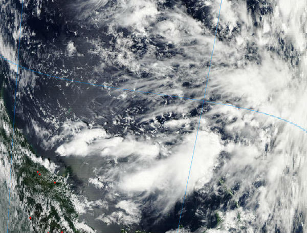
Image credit: LANCE/MODIS/Terra
The twenty-sixth tropical cyclone of the Pacific Tropical Storm season formed in western north Pacific Ocean and it is named as TS BOPHA (TS 26W). Warnings and watches are currently in effect for islands within Micronesia archipelago, thousands islands between Philippines on the west and Indonesia on the southwest. According to NOAA’s National Weather Service in Tiyan, Guam, a tropical storm warning remains in effect for Nukuoro in Pohnpei State and Lukunor in Chuuk State. A tropical storm watch remains in effect for Losap and for Chuuk Lagoon Islands in Chuuk State.
 Western/South Pacific Ocean tropical situation (Credit: SATOPS/JTWC)
NASA’s Tropical Rainfall Measuring Mission (TRMM) satellite passed over the system on November 26 at 05:26 UTC while it was still tropical depression and observed large depression’s low-level center and some fragmented convective bands of thunderstorms wrapping around it, which contained heavy rain, falling at 2 inches/50 mm per hour. TRMM data also revealed tall convective towering thunderstorms about 15 kilometers (9.3 miles) high. According to previous NASA research, those “hot towers” usually signify that a tropical cyclone will intensify.
 This near-infrared image taken from the AIRS instrument aboard NASA’s Aqua satellite on Nov. 26 at 0341 UTC shows the leading western edge of Tropical Depression 26W as it moves toward the Philippine Sea. New Guinea is seen on the bottom left corner of the image. (Credit: NASA JPL, Ed Olsen)
According to latest report by Joint Typhoon Warning Center, Tropical Storm 26w (Bopha) is located approximately 295 nm southeast
of Chuuk and is moving west-northwestward at 02 knots over the past six hours.
Forecasters at the Joint Typhoon Warning Center expect that this system will track to the west-northwest over the next several days and strengthen to typhoon status as it tracks through the warm waters of the Philippine Sea. TS26W is forecast to pass just south of Chuuk and affect Yap and Palau by the weekend of Dec. 1 and Dec. 2.
 Forecast track by JTWC
Satellite Animations
- Storm-Centered Infrared (MTSAT; NOAA/SSD)
- Storm-Centered Infrared (Aviation Color Enhancement) (MTSAT; NOAA/SSD)
- Storm-Centered Water Vapor (MTSAT; NOAA/SSD)
- Storm-Centered Visible (MTSAT; NOAA/SSD)
- Storm-Centered Visible (Colorized) (MTSAT; NOAA/SSD)
- Tropical West Pacific Infrared (MTSAT2; NOAA)
- Tropical West Pacific Enhanced Infrared (MTSAT2; NOAA)
- Tropical West Pacific Water Vapor (MTSAT2; NOAA)
- Tropical West Pacific Visible (MTSAT2; NOAA)
[…] A tropical storm watch remains in effect for Losap and for Chuuk Lagoon Islands in Chuuk State. Read story at The Watchers Share this:TwitterFacebookLike this:LikeBe the first to like this. Posted in Featured, weather […]