
Dust storm over China’s Taklimakan Desert
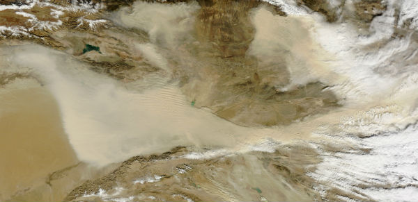
Image credit: TW
The Taklimakan Desert is China’s largest, hottest, and driest desert located far in the western part of the country. Shifting sand dunes cover About 85 percent of the desert floor is covered by shifting sand dunes, with some rising to a height of 200 meters (650 feet). It is cut off from the impacts of the Asian monsoon and Arctic storms that bring moisture to other parts of the region. Winds can easily loft the sand into the air, producing sand storms usually blowing eastward.
The Moderate Resolution Imaging Spectroradiometer (MODIS) on NASA’s Terra satellite captured image of dust blew out of the Taklimakan Desert in November 2,2012. Dust plumes—thick enough in places to completely hide the land surface below—blow away from the basin’s eastern margin.

Commenting rules and guidelines
We value the thoughts and opinions of our readers and welcome healthy discussions on our website. In order to maintain a respectful and positive community, we ask that all commenters follow these rules.