
Very strong earthquake magnitude 6.6 struck New Ireland Region, P.N.G.
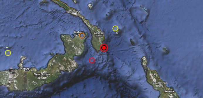
Image credit: TW
A very strong earthquake with magnitude 6.6 was recorded in New Ireland Region, Papua New Guinea on July 28, 2012 at 20:04 UTC according to USGS. Epicenter was located 124 km (77 miles) ESE (118°) from Rabaul, New Britain, PNG at 4.733°S, 153.173°E. Recorded depth was 66.7 km (41.4 miles). EMSC recorded magnitude 6.7 and depth of 60km. Epicenter is at least 50 km out of the coast.
This earthquake could not have generated tsunami.
GDACS reported that this earthquake can have a low humanitarian impact based on the Magnitude and the affected population and their vulnerability.
About 32000 people lives within 100km radius. Earthquakes with this Magnitude and depth are fairly common in Papua New Guinea.
| Magnitude | 6.6 |
|---|---|
| Date-Time |
|
| Location | 4.733°S, 153.173°E |
| Depth | 66.7 km (41.4 miles) |
| Region | NEW IRELAND REGION, PAPUA NEW GUINEA |
| Distances |
|
| Location Uncertainty | horizontal +/- 14.7 km (9.1 miles); depth +/- 11.4 km (7.1 miles) |
| Parameters | NST=120, Nph=122, Dmin=126.9 km, Rmss=1.51 sec, Gp= 18°, M-type=teleseismic moment magnitude (Mw), Version=6 |
| Source |
|
| Event ID | usb000bid9 |
Location map

Pager Map


Cities Exposed – from GeoNames Database of Cities with 1,000 or more residents.
| MMI | City | Population |
|---|---|---|
| IV | Kokopo | 26k |
| IV | Rabaul | 8k |
| IV | Namatanai | 1k |
| III | Panguna | 3k |
| III | Arawa | 40k |
| III | Kieta | 4k |
| III | Kavieng | 14k |
I'm a dedicated researcher, journalist, and editor at The Watchers. With over 20 years of experience in the media industry, I specialize in hard science news, focusing on extreme weather, seismic and volcanic activity, space weather, and astronomy, including near-Earth objects and planetary defense strategies. You can reach me at teo /at/ watchers.news.
Commenting rules and guidelines
We value the thoughts and opinions of our readers and welcome healthy discussions on our website. In order to maintain a respectful and positive community, we ask that all commenters follow these rules.