
Geomagnetic storm in progress (April 30, 2012)
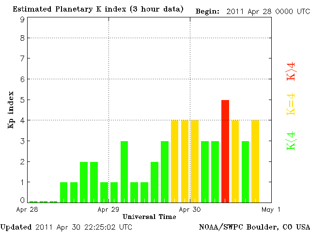
Image credit: TW
A solar wind stream hit Earth’s magnetic field during the early hours of April 30th, sparking a high-latitude geomagnetic storm (slowly subsiding). In the United States, auroras descended as far south as Marquette, Michigan, where Shawn Malone took this picture before sunrise:

High-latitude sky watchers should remain alert for auroras. The solar wind speed is high and gusty, and NOAA forecasters estimate a 40% chance of more geomagnetic activity during the next 24 hours. (SpaceWeather)
Planetary K-index
Now: Kp= 4 unsettled
24-hr max: Kp= 5 storm
Interplanetary Mag. Field
Btotal: 5.2 nT
Bz: 0.3 nT north
Solar wind
speed: 643.8 km/sec
density: 0.1 protons/cm3
Multiple C-Class flares have taken place on Saturday morning around Sunspot 1195 and 1199. There will continue to be a chance for C-Class activity around both regions which are currently rotating towards the western limb. An M-Class event is not out of the question.
The geomagnetic field ranged from unsettled to minor storm conditions as the result of coronal hole (CH) high-speed stream (HSS) effects. The solar wind speeds at the ACE spacecraft ranged between 640 km/s and 700 km/s during the period. The geomagnetic field is expected to range from unsettled to active conditions with isolated minor storms possible for days 1 and 2 (1-2 May). Mostly quiet to unsettled conditions are expected on day 3 (3 May), when CH HSS effects begin to subside. (SolarHam/NOAA/SWPC)

Earlier reporting
Nothing on Watchers was published in the last 24 hours. These are older articles.
- On October 22, 2017, a single flash of lightning stretched 515 miles from eastern Texas to near Kansas City, a distance that takes eight hours to drive, and nobody realized how far it had gone until scientists went back through the satellite data years later Epicenter
- CPC posts a slight risk of heavy rain from the Gulf Coast to the Northeast urban corridor November 25-29, and a moderate risk of West Coast wind and Sierra snow on November 25
- Florida's east coast faces a moderate flash flood risk Wednesday through Friday, with 4 to 8 inches of rain forecast and the St. Johns River near Cocoa already in major flood at 17.13 feet
- Cyclone Akvan to make landfall between Nellore and Visakhapatnam around noon on November 20, IMD forecasts 120-130 km/h winds gusting to 145
