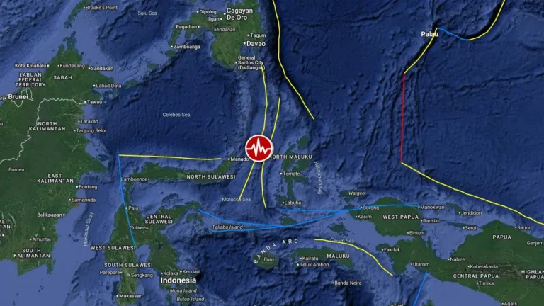
• Strong M6.0 earthquake hits Tonga

    A strong earthquake registered by the USGS as M6.0 struck near Hihifo, Tonga at 09:28 UTC on March 8, 2026. The agency is reporting a depth of 116.8 km (72.6 miles). EMSC is reporting M6.0 at a depth of 117 km (72.7 miles).

  • Strong and shallow M6.3 earthquake hits Solomon Islands

    A strong and shallow earthquake registered by the USGS as M6.3 struck 182 km (113 miles) ESE of Kirakira, Solomon Islands at 14:27 UTC on March 6, 2026. The agency is reporting a depth of 8.7 km (5.4 miles). EMSC is reporting M6.3 at a depth of 9 km (5.6 miles). According to the Pacific Tsunami Warning Center (PTWC), there is no tsunami threat from this event.

  • M4.9 earthquake near Edgefield becomes strongest inland earthquake on record in Louisiana

    An M4.9 earthquake struck near Edgefield in northwestern Louisiana, United States, at 11:30 UTC on March 5, 2026, becoming the strongest inland earthquake recorded in the state. The United States Geological Survey (USGS) reported the event at a depth of 11.1 km (6.9 miles), while the European-Mediterranean Seismological Centre (EMSC) estimated a depth of 10 km (6.1 miles). The quake was widely felt across northern Louisiana and parts of neighboring Texas.

  • Strong and shallow M6.4 earthquake hits Rat Islands, Aleutian Islands, Alaska

    A strong and shallow earthquake registered by the USGS as M6.4 hit near the Rat Islands, Aleutian Islands, Alaska at 17:54 UTC on March 4, 2026. The agency is reporting a depth of 10 km (6.2 miles). EMSC is reporting the same magnitude and depth. According to the National Tsunami Warning Center (NTWC), there is no tsunami danger from this event.

  • Strong M6.1 earthquake hits near Simeulue, Indonesia

    A strong and shallow earthquake registered by the USGS as M6.1 hit near Simeulue, Indonesia, at 04:56 UTC (11:56 local time) on March 3, 2026. The agency is reporting a depth of 26.2 km (16 miles). EMSC is reporting the same magnitude and depth.

  • Rare deep M7.1 earthquake hits beneath the Sulu Sea near Sabah, Malaysia

    A powerful and deep earthquake registered by the USGS as M7.1 struck off the coast of Kota Belud, Malaysia, at 16:57 UTC on February 22, 2026. The agency reported a depth of 620 km (385 miles). EMSC is reporting the same magnitude and depth. Due to the great depth, no tsunami was generated, and damage is unlikely. This is the largest earthquake recorded near Malaysia since the M6.6 quake in Lahad Datu in 1923.