
Taftan volcano reawakens after 710 000 years of sleep, revealing hidden hazards
A quiet, trigger-less swelling at Taftan volcano in southeastern Iran has exposed hidden instability within one of the country’s most remote volcanic systems. Using Sentinel-1 satellite InSAR enhanced by a new common-mode filtering method, scientists detected a ten-month summit uplift of about 9 cm (3.5 inches) between July 2023 and May 2024, marking the first confirmed volcanic unrest in the Makran subduction arc, where even long-silent volcanoes can awaken without warning and reveal unmonitored hazards.

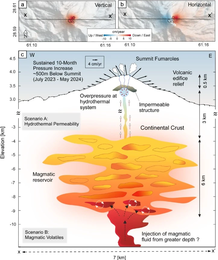
Taftan volcano magmatic system idealization. Credit: Mohammadnia et al. AGU Geophysical Research Letters
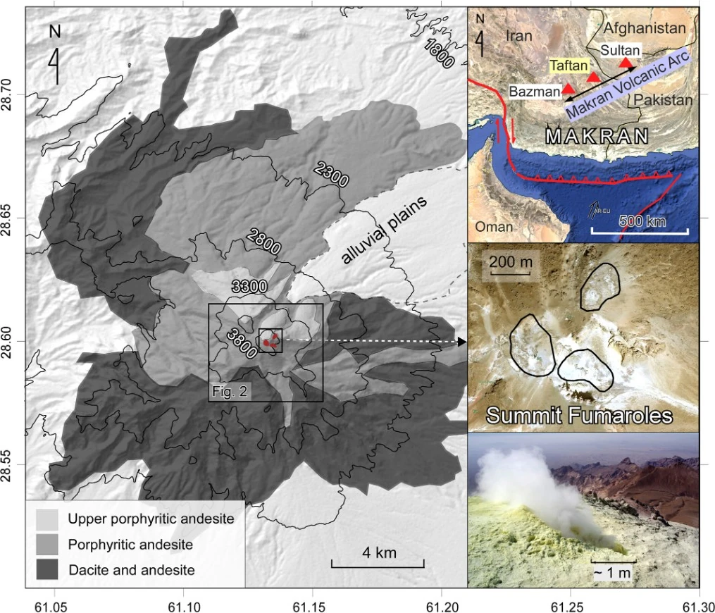
Taftan volcano rises more than 3 900 m (12 795 feet) above southeastern Iran’s desert plateau, marking the most active center of the Makran volcanic arc. The arc extends roughly 450 km (280 miles) along the Arabian–Eurasian plate boundary, where the Arabian Plate is subducting beneath Iran.
Taftan’s last dated lavas erupted around 0.71 ± 0.03 million years ago, yet fumaroles and steaming vents have persisted for decades, hinting at continuing heat and gas supply from depth.
The new study, published in October 2025 in Geophysical Research Letters, presents clear evidence that Taftan remains active. Researchers from the University of Hong Kong and the University of Liverpool applied a new atmospheric correction method known as common-mode filtering to satellite interferometry data collected between 2020 and 2024.
The method filters out atmospheric noise that often mimics volcanic deformation signals, allowing small but significant movements to be detected with greater precision.
Detecting subtle motion from orbit
InSAR, or Interferometric Synthetic Aperture Radar, measures ground deformation from orbit by comparing phase differences between radar images taken at different times.
At Taftan, standard processing already indicated a possible uplift, but the noisy atmosphere above the steep volcanic slopes made confirmation difficult. By subtracting a time-varying regional mean displacement from stable reference pixels, the new common-mode filtering reduced atmospheric contamination by as much as 50 percent.
Once the filtered data were modeled, a clear signal emerged. A localized dome-shaped uplift of about 9 cm centered on Taftan’s southeastern summit cone developed gradually over ten months.
The movement began around mid-July 2023, peaked in early 2024 at rates of about 11 cm per year (4.3 inches per year), and ceased in May 2024. The episode coincided with multiple reports of increased gas emissions and fumarolic activity at the summit.
The source beneath Taftan
Geodetic modeling indicates that the deformation originated from a shallow pressure source located roughly 490 to 630 m (1 600 to 2 070 feet) beneath the summit. This is far shallower than the magma storage reservoirs inferred from petrological data, which lie at a depth between 3.5 and 9 km (2.2 to 5.6 miles).
The shallowness of the source points toward hydrothermal pressurization rather than direct magma intrusion.
No rainfall or seismic events corresponded with the start of the deformation. Precipitation in southeastern Iran rarely exceeds 200 mm (7.9 inches) per year, and there were no earthquakes stronger than magnitude 5 within 1 000 km (620 miles) during the period. The uplift, therefore, occurred spontaneously, driven by processes internal to the volcano.
Hydrothermal pressurization or minor intrusion
The scientists propose two possible internal mechanisms.
In the first, long-term hydrothermal alteration gradually sealed pore spaces in the volcanic rock, reducing permeability and allowing gases to accumulate. As pressure increased, fractures reopened and gases escaped, slowing the inflation. This explanation is supported by reports of new summit cracks and strong sulfurous emissions observed in May 2024.
In the second scenario, a small, undetected batch of magma intruded into the deeper mush zone several kilometers below. This could have released volatile gases that rose into the overlying hydrothermal system, raising pore pressure and causing the shallow uplift.
Both mechanisms could produce the observed pattern of gradual inflation followed by increased degassing.
Taftan’s fumaroles release water vapour, carbon dioxide, sulfur dioxide, hydrogen sulfide and other gases, with sulfur dioxide fluxes averaging about 20 ± 12 tonnes per day. The emissions confirm that magmatic gases continue to supply the shallow hydrothermal system while the absence of any measurable subsidence after May 2024 suggests that pressurised fluids may still remain trapped beneath the summit.
A regional warning for the Makran arc
Comparable hydrothermal inflation has been recorded elsewhere. At Azuma volcano in Japan, uplift of about 6 cm occurred from a source at 1.3 km (0.8 miles) depth, while at La Fossa caldera on Vulcano Island in Italy, about 6 cm (0.19 feet) of uplift over three months came from a source about 0.6 km (0.4 miles) deep.
Neither event led to eruption, yet both were followed by intense degassing and ground cracking. Taftan’s uplift, slightly larger and slower, belongs to this same class of non-eruptive but potentially hazardous hydrothermal inflations.
The discovery revises perceptions of volcanic risk in southeastern Iran. The Makran arc, stretching across the Iran–Pakistan border, hosts at least three volcanic centers, Taftan, Bazman and Koh-e Sultan, but none are instrumentally monitored.
Even if they do not erupt, transient inflation can reopen fumarolic vents, release toxic gases, and trigger phreatic explosions capable of endangering nearby communities and infrastructure.
A call for holistic risk reduction
The study’s authors argue for a holistic volcano risk reduction strategy across southeastern Iran. Such a plan would include the installation of permanent GNSS and seismic stations at Taftan, continuous gas monitoring, and updated geological hazard maps.
It would also integrate satellite-based deformation monitoring into national civil-protection systems.
The measures follow the global best-practice recommendations outlined by the National Academies of Sciences in 2017 and are essential to prevent surprise crises at long-dormant volcanoes.
The Taftan study demonstrates how refined satellite processing can expose subtle hazards otherwise invisible to ground observers. The common-mode filtering method provides a simple way to remove correlated atmospheric noise in small, mountainous areas where standard corrections are insufficient.
Incorporating this approach into established software such as MintPy, StaMPS, or LiCSBAS could improve the early detection of unrest at poorly monitored volcanoes worldwide.
Taftan’s uplift shows that dormancy does not mean extinction.
References:
1 Spontaneous Transient Summit Uplift at Taftan Volcano (Makran Subduction Arc) Imaged Using an InSAR Common-Mode Filtering Method – Mohammadnia M., Yip M. W., Webb A. A. G., González P. J. – Geophysical Research Letters – DOI: https://doi.org/10.1029/2025GL114853 – OPEN ACCESS
I'm a dedicated researcher, journalist, and editor at The Watchers. With over 20 years of experience in the media industry, I specialize in hard science news, focusing on extreme weather, seismic and volcanic activity, space weather, and astronomy, including near-Earth objects and planetary defense strategies. You can reach me at teo /at/ watchers.news.
Commenting rules and guidelines
We value the thoughts and opinions of our readers and welcome healthy discussions on our website. In order to maintain a respectful and positive community, we ask that all commenters follow these rules.