Support global hazard monitoring — Join 113 supporters
Go ad-free
0% 25% 50% 75% 100%

Research shows atmospheric rivers fuel Colorado’s most extreme rainfall events

Landfalling atmospheric rivers contributed between 21% and 78% of top-decile precipitation events across Colorado between 2000 and 2023, according to a new study by the Center for Western Weather and Water Extremes (CW3E) and the National Weather Service (NWS).

Satellite image shows an atmospheric river stretching across the Pacific toward California, delivering heavy rain and snow across the region.

NOAA’s GOES-17 captured this atmospheric river stretching from the Pacific to California, an important and sometimes disastrous source of winter storms and water supply in the region Image credit: NOAA GOES-17 satellite

Landfalling atmospheric rivers (ARs) were found to contribute between 21% and 78% of Colorado’s top-decile precipitation events between 2000 and 2023, according to a new study published in JGR Atmospheres.

Led by Deanna Nash and colleagues from the Center for Western Weather and Water Extremes (CW3E) and the National Weather Service (NWS), the results of the study challenge previous estimates, which attributed less than 30% of cool-season precipitation in Colorado to ARs.

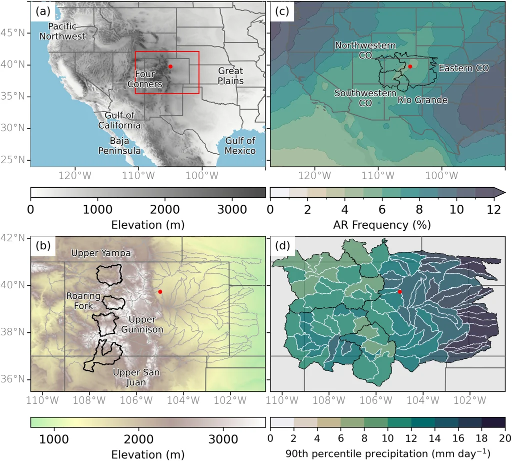
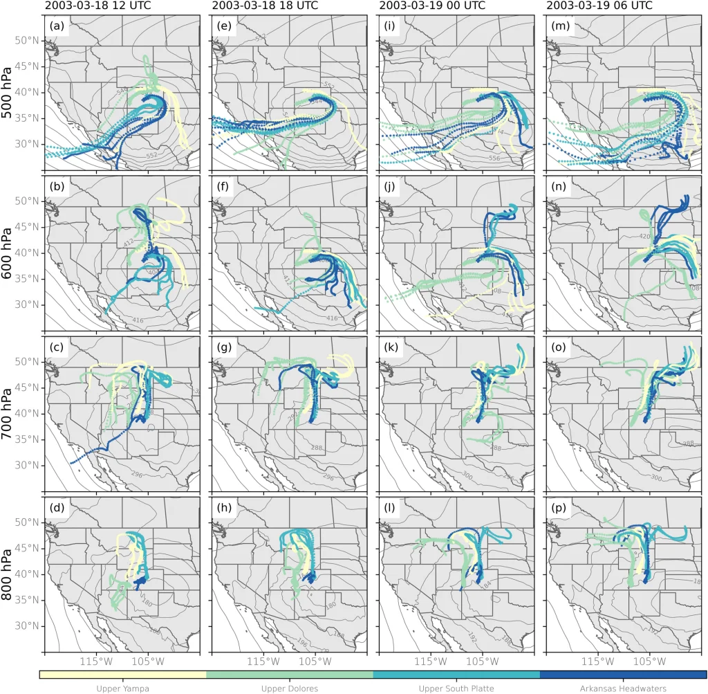
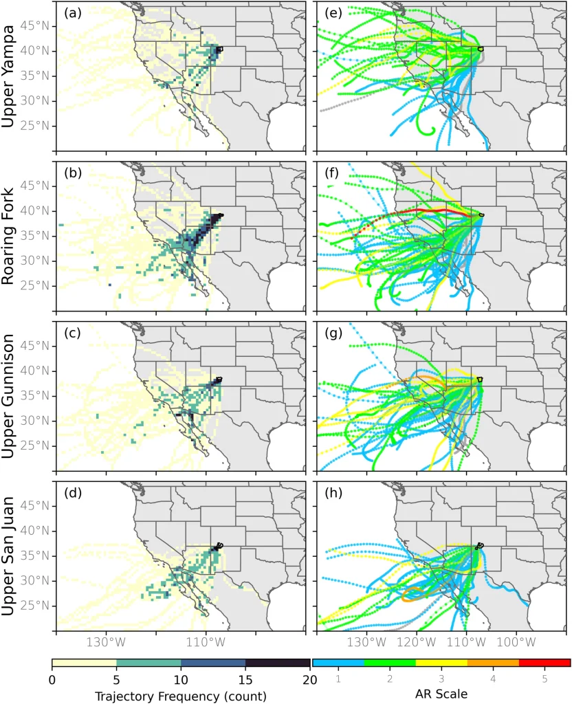
Using a backward trajectory analysis of air parcels, the researchers traced the moisture responsible for extreme precipitation in 92 hydrologic sub-basins across Colorado.

(a) Elevation (shaded, m) over western United States. The red dot indicates the location of Denver, and the red box indicates the extent in panels b and d. (b) Elevation (shaded, m) over CO. The gray contours are the HUC8 sub-basins that fall within CO. The black contours are the four sub-basins used in Figures 4 and 7 and are labeled accordingly. (c) Frequency of atmospheric river conditions (shaded, %; the fraction of analyses times meeting the criteria) between January 2000 and December 2023 based on the tARgetv4 AR detection tool using ERA5 (1 hr). The black lines enclose the four regions used to summarize the results. These results are not a part of the trajectory analysis. (d) The 90th percentile precipitation threshold for each of the HUC8 sub-basins, based on Parameter-elevation Regressions on Independent Slopes Model precipitation between 2000 and 2023. Credit: Nash, D., Rutz, J. J., Cordeira, J., Zhang, Z., Ralph, F. M., Sanders, K., & Walter, E. (2025). A trajectory-based method for estimating the contribution of landfalling atmospheric rivers to top-decile precipitation across Colorado.

The method involved identifying when and where these parcels intersected a landfalling AR on the U.S. West Coast—specifically focusing on ARs defined by the tARgetv4 detection algorithm using ERA5 reanalysis data.

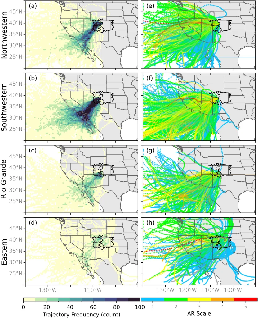
The highest contributions were observed in western Colorado, where the state’s complex topography interacts with persistent southwesterly AR pathways.

Up to 33% of analyzed trajectories, in the southwestern region, were associated with landfalling ARs. Key corridors included landfalls near Southern California and the Baja Peninsula, with AR moisture traveling inland through relatively low-elevation paths.

Examples of backward trajectories that were initialized from the grid cell closest to the centroid of the Upper Yampa (yellow), Rio Grande Headwaters (green), Upper South Platte (light blue), and Arkansas Headwaters (dark blue) sub-basins, as well as the four grid cells 0.25° north, south, east, and west of the centroids (i.e., there are 5 trajectories per sub-basin in each panel) starting at (a–d) 500 hPa, (e–h) 600 hPa, (i–l) 700 hPa, and (m–p) 800 hPa. The start time for initialization is indicated by the column where (a, e, i, and m) started on 18 March 2003 12 UTC, (b, f, j, and n) 18 March 2003 18 UTC, (c, g, k, and o) 19 March 2003 00 UTC, and (d, h, l, and p) 19 March 2003 06 UTC.
Examples of backward trajectories that were initialized from the grid cell closest to the centroid of the Upper Yampa (yellow), Rio Grande Headwaters (green), Upper South Platte (light blue), and Arkansas Headwaters (dark blue) sub-basins, as well as the four grid cells 0.25° north, south, east, and west of the centroids (i.e., there are 5 trajectories per sub-basin in each panel) starting at (a–d) 500 hPa, (e–h) 600 hPa, (i–l) 700 hPa, and (m–p) 800 hPa. The start time for initialization is indicated by the column where (a, e, i, and m) started on 18 March 2003 12 UTC, (b, f, j, and n) 18 March 2003 18 UTC, (c, g, k, and o) 19 March 2003 00 UTC, and (d, h, l, and p) 19 March 2003 06 UTC.. Credit: Nash, D., Rutz, J. J., Cordeira, J., Zhang, Z., Ralph, F. M., Sanders, K., & Walter, E. (2025). A trajectory-based method for estimating the contribution of landfalling atmospheric rivers to top-decile precipitation across Colorado.

In contrast, eastern Colorado showed far fewer landfalling AR trajectories, around 2.7%, likely due to differing seasonal precipitation dynamics dominated by convective storms and moisture from the Gulf of Mexico.

The analysis focused on top-decile precipitation events, days exceeding the 90th percentile threshold within each sub-basin. Over 11 000 such trajectories were analyzed across 23 years, using ERA5 wind and moisture fields at hourly resolution.

Results showed that traditional “overhead” detection methods underestimate AR influence inland, particularly when the AR no longer meets its geometric or IVT (integrated vapor transport) criteria after traversing complex terrain.

Landfalling atmospheric river (AR) trajectory frequency (shading; count) for all CO sub-basins that fell within the (a) northwestern, (b) southwestern, (c) Rio Grande, and (d) eastern regions (black contours) for the months of November to April from 2000 to 2023 that were associated with a landfalling AR defined by the tARgetv4 AR detection tool (e–h) Same as (a–d) but showing the tARgetv4 landfalling AR trajectories colored by the AR scale value (if applicable) at the coast.
Landfalling atmospheric river (AR) trajectory frequency (shading; count) for all CO sub-basins that fell within the (a) northwestern, (b) southwestern, (c) Rio Grande, and (d) eastern regions (black contours) for the months of November to April from 2000 to 2023 that were associated with a landfalling AR defined by the tARgetv4 AR detection tool (e–h) Same as (a–d) but showing the tARgetv4 landfalling AR trajectories colored by the AR scale value (if applicable) at the coast. Credit: Nash, D., Rutz, J. J., Cordeira, J., Zhang, Z., Ralph, F. M., Sanders, K., & Walter, E. (2025). A trajectory-based method for estimating the contribution of landfalling atmospheric rivers to top-decile precipitation across Colorado.

Synoptic analyses indicated that ARs entering through the Pacific Northwest and Gulf of Mexico, though less frequent, also contributed to some of the wettest days in northern Colorado sub-basins, such as the Upper Yampa and North Platte Headwaters.

The findings have direct implications for water resource forecasting and hydrological planning across the state, particularly in light of increasing AR activity linked to climate variability. The methodology developed here may improve future understanding of AR pathways into other interior regions of North America.

Landfalling atmospheric river (AR) trajectory frequency (shading; count) for the (a) Upper Yampa, (b) Roaring Fork, (c) Upper Gunnison, and (d) upper San Juan sub-basins (black contours) for the months of November to April from 2000 to 2023 that were associated with a landfalling AR defined by the tARgetv4 AR detection tool (e–h) Same as (a–d) but showing the tARgetv4 landfalling AR trajectories colored by the AR scale value (if applicable) at the coast.
Landfalling atmospheric river (AR) trajectory frequency (shading; count) for the (a) Upper Yampa, (b) Roaring Fork, (c) Upper Gunnison, and (d) upper San Juan sub-basins (black contours) for the months of November to April from 2000 to 2023 that were associated with a landfalling AR defined by the tARgetv4 AR detection tool (e–h) Same as (a–d) but showing the tARgetv4 landfalling AR trajectories colored by the AR scale value (if applicable) at the coast. Credit: Nash, D., Rutz, J. J., Cordeira, J., Zhang, Z., Ralph, F. M., Sanders, K., & Walter, E. (2025). A trajectory-based method for estimating the contribution of landfalling atmospheric rivers to top-decile precipitation across Colorado.

Atmospheric rivers are long, narrow bands of concentrated water vapor that transport moisture from subtropical oceans toward mid-latitudes. These systems can carry as much moisture as the Mississippi River discharges, and when they encounter terrain like the Rockies or Sierra Nevada, the uplift triggers intense precipitation.

While they are essential for seasonal water supply they can also cause damaging floods and landslides, especially during multi-day AR events.

References:

1 A trajectory-based method for estimating the contribution of landfalling atmospheric rivers to top-decile precipitation across Colorado – Nash, D., Rutz, J. J., Cordeira, J., Zhang, Z., Ralph, F. M., Sanders, K., & Walter, E. (2025). – Journal of Geophysical Research: Atmospheres – August 29, 2025 – https://doi.org/10.1029/2025JD043580 – OPEN ACCESS

I am an Assistant Editor and Severe Weather & Science Journalist at The Watchers, specializing in real-time severe weather coverage, geophysical event reporting, and research-driven scientific analysis. You can reach me at rishav(at)watchers(.)news.

Share:

Commenting rules and guidelines

We value the thoughts and opinions of our readers and welcome healthy discussions on our website. In order to maintain a respectful and positive community, we ask that all commenters follow these rules.

Leave a reply

Your email address will not be published. Required fields are marked *