
Life-threatening flash flooding reported across Oklahoma City, major flooding forecast on Canadian River
Life-threatening flash flooding was reported across the Oklahoma City metropolitan area on October 14, 2026 after thunderstorms produced 76–152 mm (3–6 inches) of rain, while radar indicated 102–279 mm (4–11 inches) farther west, according to the National Weather Service (NWS) in Norman. Major flooding was forecast on the Canadian River near Bridgeport, while the Weather Prediction Center (WPC) maintained a Moderate Risk of excessive rainfall from Oklahoma into the Red River Valley of Texas through 12:00 UTC on October 15.

Satellite image of central United States at 17:50 UTC on October 14, 2026. Credit: NOAa/GOES-East, RAMMB/CIRA, The Watchers
At 10:00 LT (15:00 UTC), NWS Norman extended a Flash Flood Warning for Oklahoma County and parts of Canadian, Cleveland, Kingfisher, and Logan counties until 13:00 LT (18:00 UTC).
Widespread flash flooding was reported across the Oklahoma City metropolitan area after 76–152 mm (3–6 inches) of rain, with another 25–76 mm (1–3 inches) possible.
NWS classified the flash-flood damage threat as considerable and described the flooding of creeks, streams, roads, underpasses and urban areas as life-threatening.

At 10:21 LT (15:21 UTC), Doppler radar indicated that 102–279 mm (4–11 inches) had fallen across parts of Canadian, Kingfisher, Blaine and Caddo counties, with another 25 mm (1 inch) possible. El Reno, Watonga, Kingfisher, Piedmont, Hinton, Geary, Okarche and Hydro were among the communities included in the warning.
At 12:20 LT (17:20 UTC), NWS issued a Flood Warning for parts of western and southwestern Oklahoma until 17:45 LT (22:45 UTC), replacing an earlier Flash Flood Warning. The agency said 76–254 mm (3–10 inches) had fallen around communities including Elk City, Weatherford, Clinton and Cordell, with flooding ongoing or expected to begin shortly.
Flash Flood Warnings also expanded east and southeast during the late morning. A warning issued at 11:22 LT (16:22 UTC) covered Cleveland County and parts of Oklahoma, Lincoln, McClain, Pottawatomie and Garvin counties after radar indicated 51–76 mm (2–3 inches), with another 25–51 mm (1–2 inches) possible.
A separate warning issued at 11:59 LT (16:59 UTC) covered central Pontotoc County, including Ada, after radar indicated 25–51 mm (1–2 inches). Another 25 mm (1 inch) was possible in the warned area.
NWS Norman upgraded the Canadian River near Bridgeport forecast from moderate to major flooding at 10:17 LT (15:17 UTC). The river stood at 5.15 m (16.9 feet) at 09:45 LT and was forecast to crest near 5.24 m (17.2 feet), above the 4.27 m (14 feet) flood stage, during the afternoon.
Moderate flooding was already occurring at Bridgeport. NWS said water near 5.18 m (17 feet) affects croplands, pastures and oil wells and can isolate higher floodplain fields, with the river forecast to fall below flood stage late October 15.
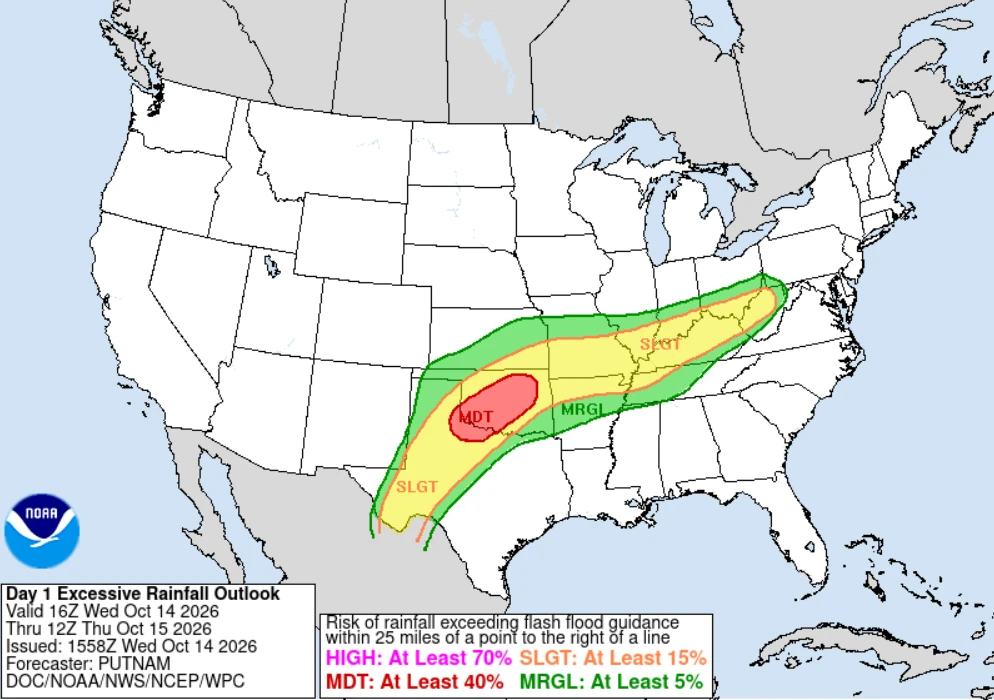
WPC maintained a Moderate Risk of excessive rainfall, level 3 of 4, across portions of Oklahoma into the Red River Valley of Texas from 16:00 UTC on October 14 to 12:00 UTC on October 15. A Moderate Risk represents at least a 40% probability of rainfall exceeding flash-flood guidance within 40 km (25 miles) of a point; it does not mean every location inside the risk area will flood.
WPC attributed the event to an approaching upper-level low and frontal boundary interacting with unusually deep moisture from the Gulf of Mexico and the eastern Pacific. The 12:00 UTC Norman sounding measured precipitable water of 56.6 mm (2.23 inches), the highest October value in its period of record.
Moisture associated with Hurricane Simon over the eastern Pacific also contributed to the unusually moist environment. WPC expected a temporary reduction in thunderstorm intensity during the early afternoon before instability and strengthening low-level flow supported renewed development later in the day and overnight.
WPC forecast a broad 51–102 mm (2–4 inches) rainfall corridor from south-central Kansas to the Texas Big Bend during the 48-hour period ending at 12:00 UTC on October 16. The agency said thunderstorms training over the same areas could produce numerous instances of flash flooding.
The excessive-rainfall threat continues on October 15, when WPC has a Slight Risk in effect across portions of West Texas into Oklahoma through 12:00 UTC on October 16. The strongest continuing heavy-rain signal was focused over the southern High Plains and southwestern Texas, while lingering flash-flood potential remained across southern Oklahoma.
NWS advises motorists never to enter flooded roads or drive around barricades, noting that most flood deaths occur in vehicles.
References:
1 Excessive Rainfall Discussion – NWS/WPC – October 14, 2026

Rishav Kothari is Editor-in-Chief of The Watchers, where he runs the newsroom and covers earthquakes, volcanoes, severe weather and space weather.
