
Tropical Depression Nine forms over Gulf of America, forecast to become hurricane before approaching U.S. Gulf Coast
Tropical Depression Nine formed over the southwestern Gulf of America on October 6, 2026, and is forecast to strengthen into a tropical storm early Wednesday and a hurricane on Thursday. The system is expected to approach the U.S. northern Gulf Coast on Friday, with an increasing risk of dangerous wind, storm surge, and heavy rainfall impacts.
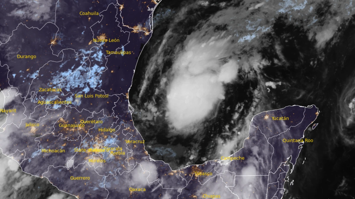
Satellite image of Tropical Depression 9 at 07:30 UTC on October 7, 2026. Credit: NOAA/GOES-19, RAMMB/CIRA, The Watchers
- NHC forecasters warn there is an increasing risk of dangerous wind and storm surge impacts along portions of the northern Gulf Coast, and watches could be required on Wednesday, October 7. Residents from Louisiana to the Florida Panhandle should closely monitor the latest forecast updates and ensure they have their hurricane plan in place.
- The system will bring areas of heavy rainfall to the central U.S. Gulf Coast Friday into the weekend. Flash and urban flooding, along with isolated river flooding, will be possible.
- Yucatan Peninsula of Mexico: The depression is expected to strengthen and could bring gusty winds and areas of heavy rain to the western portion of the Yucatan Peninsula in a couple of days.
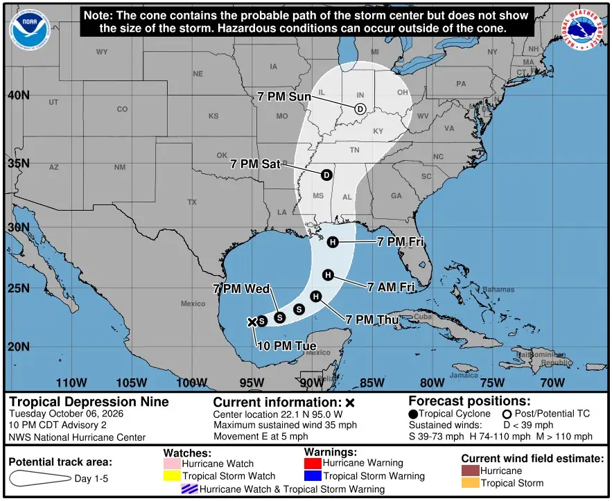
As of 03:00 UTC on Wednesday, October 7 (10:00 p.m. CDT Tuesday), the center of the depression was located about 555 km (345 miles) west of Progreso, Mexico, and 975 km (605 miles) southwest of the mouth of the Mississippi River.
1-minute sustained winds were near 55 km/h (35 mph) with higher gusts, and the estimated minimum central pressure was 1 005 hPa. The system was moving east at 7 km/h (5 mph).
An east-northeastward motion is expected through Thursday, taking the center north of the Yucatan Peninsula, followed by a turn toward the northeast and north on Friday. On this track, the depression is forecast to approach the U.S. northern Gulf Coast on Friday.
NHC said confidence in the track forecast is below average because of significant spread among forecast models.
Steady strengthening is expected. The depression should become a tropical storm early Wednesday, with winds near 75 km/h (45 mph), and reach hurricane strength on Thursday, with winds near 140 km/h (85 mph).
The latest NHC forecast shows peak winds near 155 km/h (100 mph), Category 2 strength, over the central Gulf by Friday before the system nears the coast. Strong wind shear is likely to cap further strengthening, and the system is expected to grow in size, with rain and wind impacts extending well east of the center.
No coastal watches or warnings were in effect as of Tuesday night. NHC said watches could be required on Wednesday, with an increasing risk of dangerous wind and storm surge impacts along portions of the northern Gulf Coast.
Residents from Louisiana to the Florida Panhandle were advised to closely monitor updates and ensure their hurricane plans are in place.
Rainfall of 50 to 100 mm (2 to 4 inches) is expected through Thursday along coastal portions of the Bay of Campeche, with isolated higher amounts in the Mexican states of Campeche and western Yucatan.
From Friday through the weekend, 75 to 150 mm (3 to 6 inches) of rain is forecast across the central U.S. Gulf Coast from southeastern Louisiana to the Florida Panhandle, with localized totals up to 250 mm (10 inches). Flash and urban flooding, along with isolated river flooding, will be possible.
Gusty winds are possible in portions of the Yucatan Peninsula on Thursday. Swells are expected to reach the western and northern Yucatan Peninsula beginning Thursday and spread north toward the Gulf Coast late this week, likely causing life-threatening surf and rip current conditions.
1 Tropical Depression Nine Public Advisory Number 2 – NOAA/NHC – October 7, 2026
2 Tropical Depression Nine Forecast Discussion Number 2 – NOAA/NHC – October 7, 2026

Rishav Kothari is Editor-in-Chief of The Watchers, where he runs the newsroom and covers earthquakes, volcanoes, severe weather and space weather.
Published in the last 24 hours
- New Mexico’s Navajo Reservoir rose nearly 60 feet in seven weeks this fall, after a winter with almost no snow, as storms flooded the San Juan River Epicenter
- The storms drenching California this week are fed by a river in the sky, a band of water vapor that can carry up to 15 times the flow of the Mississippi River, and this winter’s near-record El Niño could keep aiming more of them at the West Coast
- Malawi continues Bris AI weather forecasting tests ahead of operational integration Epicenter
- Right about now, Voyager 1 is crossing a line no human-made object has ever reached, a full light-day from Earth, which means a message NASA sends tonight won't arrive until tomorrow night, and the spacecraft's answer won't make it home until the night after that
