
Flood Watch issued for northeastern Florida as AL92 raises late-week Gulf Coast rainfall threat, U.S.
A Flood Watch is in effect for northeastern Florida and Camden County, Georgia, from 10:00 to 20:00 EDT (14:00 UTC October 6 to 00:00 UTC October 7), with the National Weather Service (NWS) forecasting locally 76–127 mm (3–5 inches) of rain. The Weather Prediction Center (WPC) maintains a Marginal Risk of excessive rainfall across much of Florida through Thursday, while a broader heavy-rain threat is forecast along the northern Gulf Coast from Friday as disturbance AL92 moves northeastward and interacts with an upper-level trough.
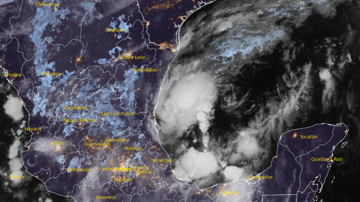
Satellite image of AL92 at 10:20 UTC on October 6, 2026. Credit: NOAA/GOES-19, RAMMB/CIRA, The Watchers
A slow-moving front continued to move southward from Georgia and Alabama into northern Florida on October 6. WPC placed much of Florida and far southeastern Georgia under a Marginal Risk of excessive rainfall through 08:00 EDT (12:00 UTC) on October 7, indicating that isolated flash flooding is possible.
WPC forecast widespread rainfall of 25–76 mm (1–3 inches) across much of northern Florida during the period. The agency said soils were saturated following rain during previous days, but generally low rainfall rates and the region’s flat, sandy and swampy terrain are expected to limit the broader flash-flood threat.
Urban and poor-drainage locations remain more vulnerable. WPC said localized training storms could produce heavier rainfall and scattered flash flooding, although these impacts were expected to be isolated.

Valid 1200Z Tue Oct 06 2026 Through 1200Z Wed Oct 07 2026. Credit: NWS/WPC
NWS Jacksonville issued the Flood Watch at 01:12 EDT (05:12 UTC) on October 6 for parts of northeastern Florida and Camden County in southeastern Georgia. Atlantic rainbands could produce locally 76–127 mm (3–5 inches) through the afternoon and early evening, with excessive runoff capable of flooding urban, low-lying, and poor-drainage locations.
The front is forecast to stall near Florida’s Big Bend and First Coast on October 7. Drier air should reduce rainfall near the Interstate 10 corridor, while the main focus will shift toward the Interstate 4 corridor.
WPC forecasts 25–76 mm (1–3 inches) on the Gulf Coast side of the Interstate 4 corridor and generally 25–51 mm (1–2 inches) on the Atlantic side. Local totals near 152 mm (6 inches) are possible where storms repeatedly cross the same area.
A Marginal Risk remains in effect across much of Florida from 08:00 EDT (12:00 UTC) on October 8 through 08:00 EDT (12:00 UTC) on October 9. The stalled front is forecast to retreat northward as a warm front, returning the heaviest rain to parts of northern Florida and maintaining an isolated flash-flood threat.
The current Florida rainfall is associated primarily with the frontal boundary. Separately, a trough of low pressure designated AL92 was producing disorganized showers and thunderstorms over the southwestern Gulf at 02:00 EDT (06:00 UTC) on October 6, according to the National Hurricane Center (NHC).

NHC gave AL92 an 80% chance of tropical cyclone formation through both 48 hours and seven days and said a tropical depression was likely to form within the next couple of days. The disturbance was forecast to drift east-northeastward through midweek before turning northward, but NHC said it was too early to determine specific impacts along the northern Gulf Coast.
WPC expects the rainfall pattern to change after Thursday as AL92’s circulation moves northeastward from the Bay of Campeche and interacts with an approaching upper-level trough.
A Slight Risk of excessive rainfall covers parts of the northern Gulf Coast beginning October 9 and expands into parts of the Lower Mississippi Valley, Tennessee Valley and Southeast during the weekend.
Forecast confidence is increasing that a swath of 76-178 mm (3-7 inches) of rain will fall during the late-week and weekend event. WPC described the Day 5 outlook as a high-end Slight Risk but withheld a Moderate Risk because uncertainty remains over tropical development, track, timing, and interaction with the upper-level trough.
References:
1 Excessive Rainfall Discussion – NWS/WPC – October 6, 2026
2 Atlantic Tropical Weather Outlook – NOAA/NHC – October 6, 2026

I am an Assistant Editor and Severe Weather & Science Journalist at The Watchers, specializing in real-time severe weather coverage, geophysical event reporting, and research-driven scientific analysis. You can reach me at rishav(at)watchers(.)news.

Commenting rules and guidelines
We value the thoughts and opinions of our readers and welcome healthy discussions on our website. In order to maintain a respectful and positive community, we ask that all commenters follow these rules.