
Baja California Sur prepares for Hurricane Polo ahead of Monday landfall, Mexico
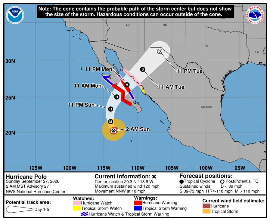
Hurricane warnings covered portions of both coasts of Baja California Sur on September 27, 2026, as Major Hurricane Polo moved north-northwest toward the peninsula, according to the National Hurricane Center (NHC). At 02:00 MST (09:00 UTC), the Category 3 hurricane had maximum sustained winds of 195 km/h (120 mph) and was forecast to approach the western coast on Monday, cross the peninsula Monday night and approach northwestern mainland Mexico early Tuesday.
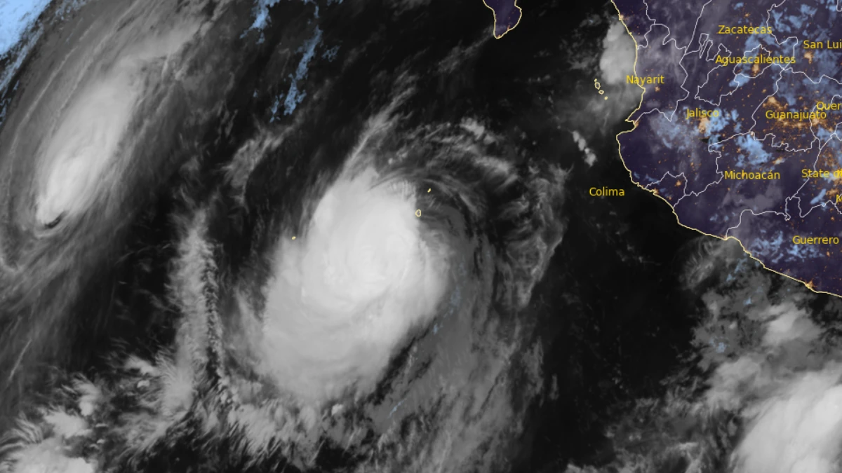
Satellite image of Hurricane Polo at 12:30 UTC on September 26, 2026. Credit: NOAA/GOES-19, RAMMB/CIRA, The Watchers
Polo was centered approximately 480 km (300 miles) southwest of Cabo San Lucas and 520 km (320 miles) south-southwest of Cabo San Lázaro. It was moving north-northwest at 17 km/h (10 mph), with a minimum central pressure of 952 hPa.
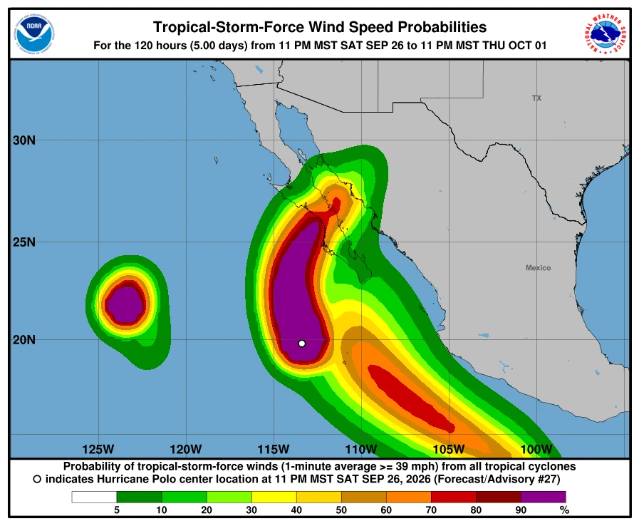
Hurricane-force winds extended up to 75 km (45 miles) from Polo’s center, while tropical-storm-force winds extended up to 205 km (125 miles).
Polo had weakened considerably from its earlier Category 5 intensity but remained a major hurricane. Satellite observations continued to show indications of an eye, and NHC maintained the cyclone’s intensity at Category 3.
Polo was forecast to turn northward later on September 27 and northeastward on Monday. The hurricane was expected to approach western Baja California Sur on Monday, cross the peninsula Monday night and approach northwestern mainland Mexico early Tuesday.
NHC forecast gradual weakening before Polo reached the peninsula. Increasing southwesterly wind shear and interaction with land were expected to cause rapid weakening after landfall.
Polo was not expected to strengthen again over the Gulf of California because of strong wind shear. NHC indicated that it could still be near hurricane strength when it reached mainland Mexico, although the intensity of this second landfall remained uncertain.
Uncertainty also remained over Polo’s forward speed after it turned northeastward. The forecast models showed greater-than-usual differences concerning how quickly the cyclone would move after crossing Baja California Sur.
A Hurricane Warning was in effect for the western coast of Baja California Sur from Punta Abreojos to Santa Fe. The eastern coast of Baja California Sur from Loreto to Santa Rosalía.
A Hurricane Watch was in effect for the western coast north of Punta Abreojos to Punta Eugenia. The eastern coast south of Loreto to San Evaristo. The eastern coast north of Santa Rosalía to Bahía San Juan Bautista. Mainland Mexico from Huatabampito to Bahía Kino.
A Tropical Storm Warning was in effect for the western coast of Baja California Sur north of Punta Abreojos to Punta Eugenia. The eastern coast north of Santa Rosalía to Bahía San Juan Bautista. The eastern coast south of Loreto to San Evaristo.
A Tropical Storm Watch covered mainland Mexico south of Huatabampito to Topolobampo. Residents elsewhere in Baja California Sur, Sonora and northern Sinaloa were advised to monitor Polo’s progress.
Hurricane conditions were expected along the warned portion of western Baja California Sur by Monday afternoon. Tropical-storm conditions could begin in the southern portion of the warning area Sunday night or early Monday before spreading northward and then eastward across the peninsula.
Hurricane conditions were possible within the mainland Hurricane Watch area on Tuesday. NHC urged residents in warning areas to complete preparations before tropical-storm-force winds made outside work difficult or dangerous.
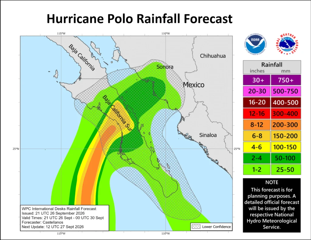
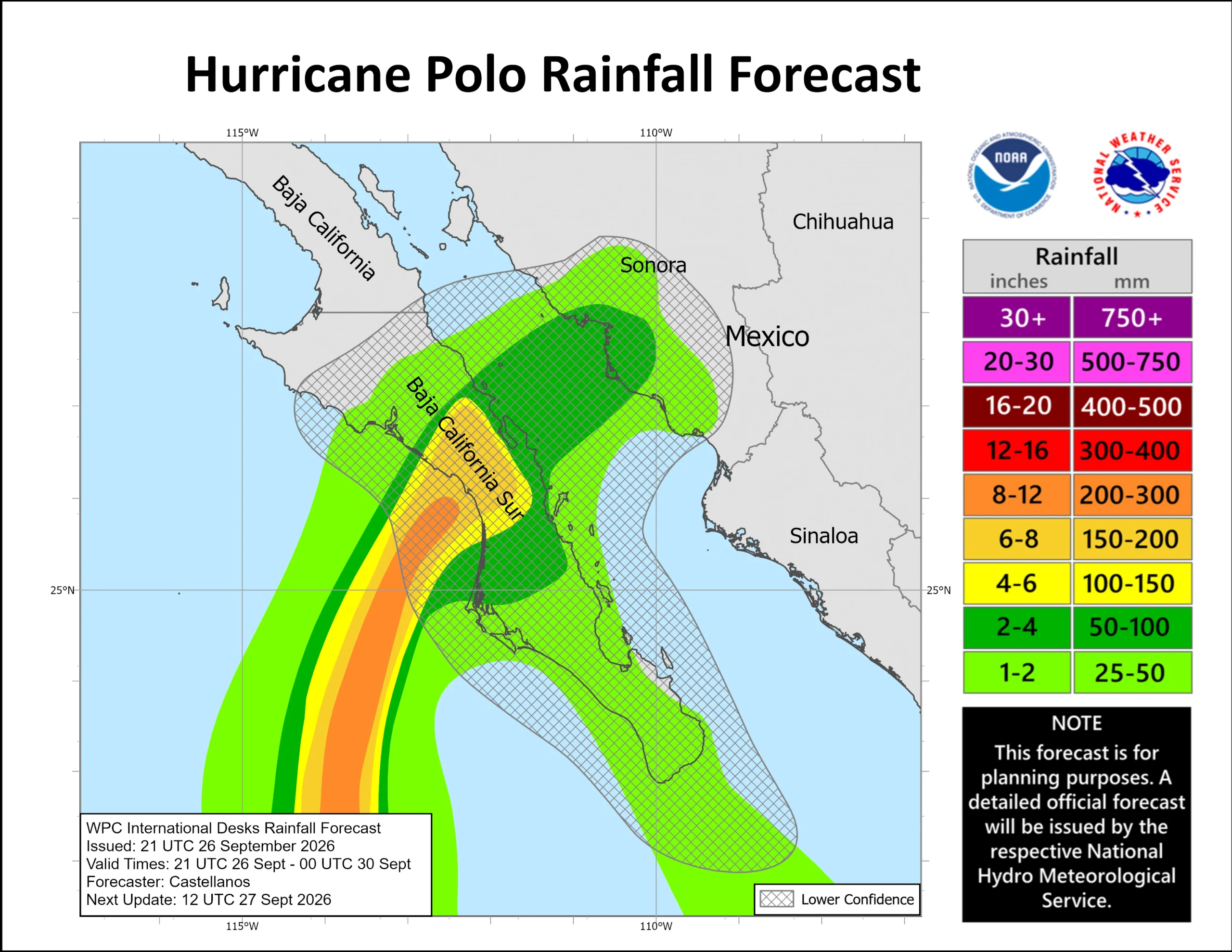
Polo is forecast to produce rainfall totals of 100–200 mm (4–8 inches), with isolated maxima near 250 mm (10 inches), across portions of Baja California Sur. Rainfall may begin Sunday night and continue into Tuesday, producing possible life-threatening flooding and mudslides, particularly in steep terrain.
Storm surge could produce significant coastal flooding in areas exposed to onshore winds. Large and destructive waves were expected near the coast.
Swells generated by Polo were affecting southwestern Mexico, west-central Mexico and Baja California Sur. The swells were forecast to spread northward along the peninsula, producing life-threatening surf, rip currents and coastal flooding.
Baja California Sur’s State Civil Protection Council extended the suspension of classes across all five municipalities through Tuesday, September 29. State, municipal and federal government operations were also suspended Monday and Tuesday, while individual businesses were permitted to determine whether to operate.
All maritime activities in Baja California Sur had been suspended. Authorities established a command post in Comondú to coordinate emergency preparations and response operations.
The state had designated 169 temporary shelters with combined capacity for 33 192 people. These included 111 shelters under Plan A and 58 under Plan B, with their activation dependent on local conditions.
State health authorities assigned medical and nursing personnel to shelters expected to open under Plan A. Hospitals were also preparing medicines, supplies and arrangements to maintain refrigeration for vaccines and temperature-sensitive medicines.
Machinery, emergency equipment and personnel had been deployed toward Comondú and Mulegé. Mexican Army teams from the Third Combat Engineers Battalion were also deployed toward Los Cabos and Comondú under Plan DN-III-E.
NHC forecast Polo to weaken rapidly after crossing Baja California Sur and dissipate over northern Mexico by Wednesday. The cyclone was not expected to reach the southern United States.
Moisture associated with Polo and Hurricane Odalys was nevertheless forecast to enter the southwestern United States. This moisture could indirectly contribute to heavy rainfall and flash flooding late in the weekend and early the following week.
References:
1 Hurricane Polo Public Advisory Number 27 – NOAA/NHC – September 27, 2026
2 Hurricane Polo Forecast Advisory Number 27 – NOAA/NHC – September 27, 2026.
3 Hurricane Polo Discussion Number 27 – NOAA/NHC – September 27, 2026
4 Preventive measures strengthened ahead of possible Hurricane Polo impacts – Government of Baja California Sur – September 26, 2026

Rishav Kothari is Editor-in-Chief of The Watchers, where he runs the newsroom and covers earthquakes, volcanoes, severe weather and space weather.
Published in the last 24 hours
- In 1920, a man out hunting on a farm in Namibia sat down on a strange black rock, scratched it with his knife and saw metal shine underneath. It was Hoba, a 60-ton meteorite, the largest ever found, and there is no crater around it Epicenter
- On December 26, 2004, a 10-year-old British girl on a Phuket beach recognized the frothing sea from a recent geography lesson, and her warning helped clear the beach before the tsunami struck Epicenter
