
One dead, tens of thousands without power as nor’easter impacts U.S. Northeast
A long-duration nor’easter continued producing coastal flooding, heavy rain and strong winds from Virginia to New England on September 27, 2026, leaving tens of thousands of utility customers without power. Coastal Flood Warnings remained in effect along parts of the U.S. East Coast, while a 56-year-old man was killed and four people were injured in separate falling-tree incidents in Brooklyn, New York, on September 26.
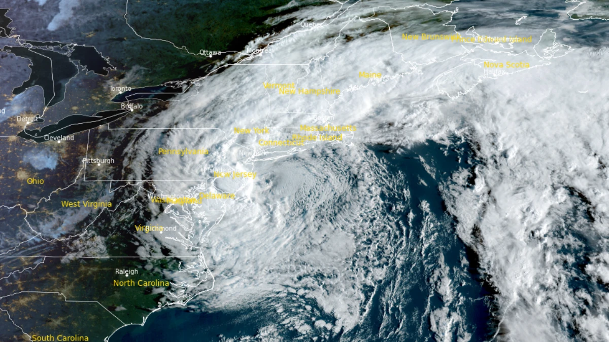
Satellite image of the nor'easter storm impacting the U.S. East Coast at 11:50 UTC on Sept 27, 2026. Credit: NOAA/GOES-19, RAMMB/CIRA, The Watchers
The National Weather Service (NWS) New York/Upton office placed the storm’s center south of Long Island and east of New Jersey at 08:00 UTC on September 27. The low was forecast to move westward toward New Jersey, stall near the coast Sunday night and drift slowly eastward on Monday while weakening.
PowerOutage.com reported approximately 37 450 customers without electricity in New York and 29 740 in Connecticut at the reporting cutoff. Additional outages in New Jersey, Massachusetts, Pennsylvania and Rhode Island brought the six-state total above 90 000.
Suffolk County accounted for more than 21 000 of the New York outages. Eversource reported more than 27 000 customers without power in Connecticut.
A 56-year-old New York City Housing Authority employee was killed when a tree fell on him in a parking area at 700 Euclid Avenue in East New York, Brooklyn, at approximately 15:30 EDT (19:30 UTC) on September 26. The investigators had not determined whether storm winds caused the tree to fall.
Four people suffered minor injuries when another tree fell at Kelly Park Playground in Brooklyn at approximately 17:30 EDT (21:30 UTC), according to the New York City Fire Department. They were taken to Maimonides Medical Center.
The New York City Parks Department had received more than 350 reports of fallen trees by 18:00 EDT (22:00 UTC) on September 26.
An NWS public information statement listed gusts of 98 km/h (61 mph) at Farmingdale Airport, New York, and 90 km/h (56 mph) at John F. Kennedy International Airport and Bridgeport Airport, Connecticut, on September 26. A gust of 74 km/h (46 mph) was recorded at Brooklyn College.

Coastal Flood Warnings remained in effect across New York City, Long Island and parts of coastal Connecticut through 18:00 EDT (22:00 UTC) on September 27. NWS forecast inundation of approximately 0.6–0.8 m (2–2.5 feet) above ground in vulnerable waterfront areas, locally reaching 1 m (3 feet).
Widespread moderate to locally major flooding remained possible along the back bays of southern Nassau and southwestern Suffolk counties. Breaking waves of approximately 2–3 m (6–9 feet) were forecast along exposed sections of Long Island.
NWS expected additional rainfall of 25–50 mm (1–2 inches), with locally higher totals across Connecticut, Long Island and the New York City metropolitan area through Sunday evening. Widespread minor urban, poor-drainage and small-stream flooding was considered likely, with isolated flash flooding possible.
High Wind Warnings had been replaced by Wind Advisories across Long Island and southeastern Connecticut on Sunday morning. Gusts of 65–72 km/h (40–45 mph) remained possible, particularly near the coast, before winds gradually weakened.

In New Jersey, High Wind Warnings remained in effect for coastal Monmouth and Ocean counties through noon EDT on September 27, while Wind Advisories covered a broader area. NWS Mount Holly warned that the combination of saturated ground, strong winds and trees retaining their leaves could cause additional tree and power-line damage.
Coastal Flood Warnings continued along much of the New Jersey and Delaware coast through 14:00 EDT (18:00 UTC). Inundation of approximately 0.3–0.6 m (1–2 feet) was expected in low-lying shoreline and tidal-waterway areas, with widespread roadway flooding and some damage to vulnerable structures possible.
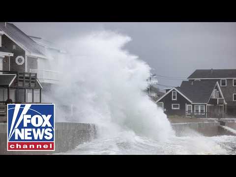
Breaking waves of 2–4 m (6–12 feet) were forecast along the Jersey Shore and Delaware Beaches. NWS warned of dangerous rip currents, additional beach erosion and possible dune breaching.
Preliminary NWS rainfall observations through the evening of September 26 included 72.4 mm (2.85 inches) at Spring Lake Heights, 70.1 mm (2.76 inches) at Neptune and 65.0 mm (2.56 inches) at Brick, New Jersey.

New Jersey’s state of emergency remained in effect across Atlantic, Burlington, Cape May, Cumberland, Middlesex, Monmouth, Ocean and Salem counties. Executive Order No. 25 activated the State Emergency Operations Center and coordination among state agencies and county emergency-management offices.
Connecticut activated its Emergency Operations Center on September 25. State agencies, municipalities, utilities and partner organizations were coordinating through the center during the storm.
Across southern New England, NWS Boston/Norton said the strongest winds had passed by early September 27 and canceled High Wind Warnings across eastern Massachusetts and Rhode Island. Windswept rain, minor coastal flooding, beach erosion and localized urban and street flooding were forecast to continue into Monday.
Rainfall totals of 50–100 mm (2–4 inches) were forecast across much of southern New England, with isolated totals of 125–180 mm (5–7 inches). Flood Watches remained in effect across parts of Massachusetts and Rhode Island through late Monday.
FlightAware recorded 451 canceled flights and 3 332 delays involving airports within, into or out of the United States on September 26. These were nationwide totals covering all causes and should not be interpreted as an exact count of storm-related disruptions.
The nor’easter had earlier caused prolonged tidal flooding in Norfolk, Virginia. The municipal government reported continuing roadway flooding, drainage problems and transportation impacts on September 26, while warning that some roads could become impassable around high tide.
A Coastal Flood Warning for Norfolk remained in effect through 14:00 EDT (18:00 UTC) on September 27. The city said minor to moderate flooding was expected, with major flooding possible in some locations.
NWS offices forecast the storm to weaken gradually near the New Jersey coast through Monday. Rain and coastal flooding could persist in some areas before broader improvement on Tuesday.
References:
1 State of emergency declared across eight counties – Government of New Jersey – September 25, 2026
2 Connecticut Emergency Operations Center activated – Government of Connecticut – September 25, 2026
3 Coastal Flood Warning update – City of Norfolk – September 26, 2026.
4 Short Range Forecast Discussion – NWS/WPC – September 27, 2026

Rishav Kothari is Editor-in-Chief of The Watchers, where he runs the newsroom and covers earthquakes, volcanoes, severe weather and space weather.
Published in the last 24 hours
- Northern lights are possible at high latitudes on November 17 and 18 as NOAA forecasts minor (G1) geomagnetic storms from coronal hole wind
- In February 2022, SpaceX launched 49 Starlink satellites into a solar storm so mild that forecasters rated it minor, and within days 38 of them had fallen back and burned up, because the storm had swollen the thin air they were flying through Epicenter
- On a Friday night in October 1992, a fireball over the eastern US was filmed by fans at high school football games before it punched through the trunk of a teenager’s $400 Chevy Malibu in Peekskill, New York, and she sold the wrecked car for $10,000 Epicenter
- Green Lake, Hawaii's largest freshwater lake, was gone by the afternoon of June 2, 2018, after lava from Kilauea filled its basin. The water was about 20 feet deep, not the 200 feet often claimed. Epicenter
