
Copernicus: August 2026 sets ERA5 temperature record as extra-polar SSTs hit record highs
Global surface air temperature averaged 16.96°C (62.53°F) in August 2026, making it the warmest August in the ERA5 dataset, the Copernicus Climate Change Service (C3S) reported on September 10, 2026. The month was 1.65°C (2.97°F) above the estimated 1850–1900 pre-industrial average, while extra-polar sea surface temperature (SST) averaged a record 21.07°C (69.93°F) and reached a daily ERA5 record of 21.11°C (70°F) on August 24 and 25.

Image credit: C3S/ECMWF
Global-average surface air temperature and average extra-polar sea surface temperature reached record August levels in ERA5 in August 2026, according to the Copernicus Climate Change Service (C3S).
Surface air temperature averaged 16.96°C (62.53°F), making it the warmest August and joint-warmest calendar month in ERA5, while sea surface temperature (SST) across the extra-polar oceans averaged 21.07°C (69.93°F), the dataset’s highest August value.
The European Centre for Medium-Range Weather Forecasts (ECMWF) measured the global August temperature at 0.85°C (1.53°F) above the 1991–2020 average.
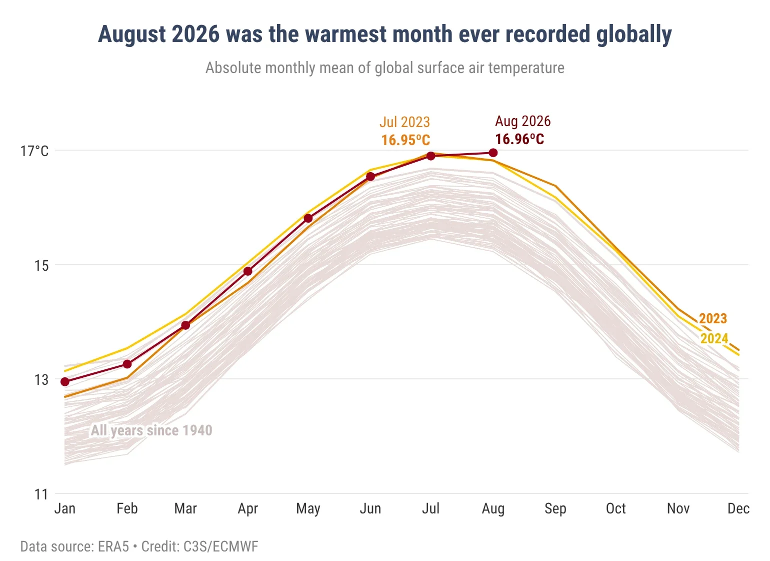
The previous August record was shared by 2023 and 2024, both of which averaged 16.82°C (62.28°F). July 2023 averaged 16.95°C (62.51°F), leaving a difference of less than 0.01°C (0.02°F) between that month and August 2026. C3S therefore classified the two months as jointly warmest in ERA5.
Across the extra-polar oceans between 60°S and 60°N, SST averaged 21.07°C (69.93°F) in August 2026, exceeding the previous August record of 20.98°C (69.76°F) set in 2023. The value also matched March 2024 as the highest monthly extra-polar SST across all calendar months in ERA5.
C3S cautioned that the August monthly SST was not the highest on record in some other datasets. ERA5 SSTs represent estimated ocean temperatures at approximately 10 m (33 feet) depth, known as foundation temperatures, and may differ from products estimating temperatures at other depths.
Daily extra-polar SST in ERA5 reached 21.11°C (70.00°F) on August 24 and 25, exceeding the previous daily record of 21.09°C (69.96°F) set in March 2024. C3S reported that daily extra-polar SST had ranked highest for each corresponding calendar day since June 19.
Record-high August SSTs occurred across large areas of the Pacific Ocean, particularly the central and eastern tropical Pacific. El Niño conditions were present across the equatorial Pacific and were expected to strengthen further.
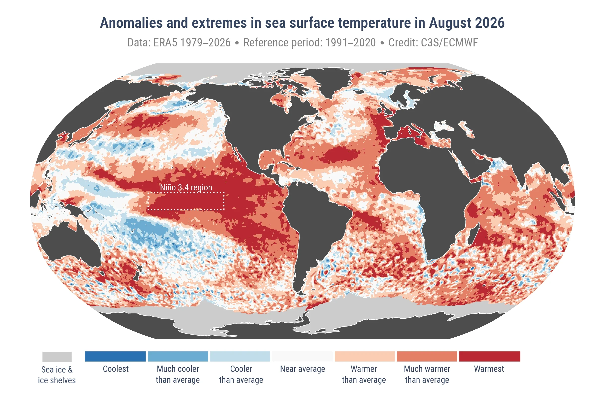
Much-warmer-than-average conditions also affected the northern North Pacific, large areas of the Southern Hemisphere oceans and the subtropical North Atlantic. Record-high August SSTs occurred along Europe’s Atlantic coast and in the western Mediterranean, where strong to severe marine heatwave conditions were widespread.
Relative to the estimated 1850–1900 pre-industrial baseline, the August global surface air temperature was 1.65°C (2.97°F) higher, marking the first monthly reading above 1.5°C (2.7°F) since November 2025. The running 12-month average from September 2025 through August 2026 was 1.48°C (2.66°F) above the estimated pre-industrial level.
This monthly exceedance does not mean that the Paris Agreement’s long-term 1.5°C (2.7°F) temperature level has been crossed. The World Meteorological Organization (WMO) says the agreement’s 1.5°C (2.7°F) and 2°C (3.6°F) levels refer to warming sustained over an extended period, typically assessed over 20 years.
August 2026 was 0.06°C (0.11°F) warmer than July 2026. This sequence is unusual because July is normally the warmest calendar month globally.
ERA5 extends back to 1940, and C3S identified only four previous years in which August was warmer than July in the same year: 1945, 1951, 1955 and 1985.
Global land temperature reached its highest August value in ERA5 at 15.73°C (60.31°F), slightly above the previous August record of 15.71°C (60.28°F) set in 2024. It was not, however, the highest global land temperature recorded across all calendar months.
Global temperature during the June–August 2026 boreal summer averaged 0.69°C (1.24°F) above the 1991–2020 level, matching 2024 as the highest boreal-summer anomaly in ERA5.
For January through August, 2026 ranked as the second-warmest year to date in ERA5, behind 2024 and ahead of 2023. C3S noted that El Niño conditions are strengthening and said that if the final four months of 2026 are as warm as the corresponding months of 2023, the annual average for 2026 would approach that of 2024.
European land averaged 20.26°C (68.47°F) during August, 1.10°C (1.98°F) above the 1991–2020 average and the fourth-highest August value in ERA5. It was 0.63°C (1.13°F) below the European August record set in 2022.
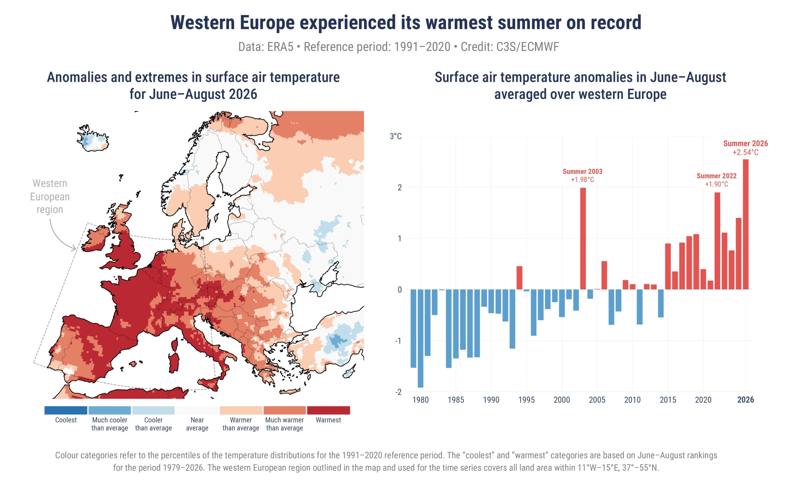
Temperatures across France, Italy, Bosnia and Herzegovina, Croatia, Hungary, Romania and much of the Balkans were generally 3–5°C (5.4–9°F) above average. Slightly below-average temperatures occurred across northern Europe from Iceland through Fennoscandia and the Baltic countries.
Western Europe completed its warmest summer in ERA5, averaging 21.69°C (71.04°F) from June through August. This was 2.54°C (4.57°F) above the 1991–2020 seasonal average and surpassed the previous record established in 2003.
For this analysis, C3S defined western Europe as the area between 11°W and 15°E and between 37°N and 55°N.
ERA5 placed average summer temperatures at their highest since at least 1979 across virtually all of England, Wales and Belgium, and across most of France, Spain, Italy, Switzerland and Austria.
References:
1 Surface air temperature for August 2026 — C3S/ECMWF — September 10, 2026
2 Copernicus: August was the world’s joint hottest month on record — C3S/ECMWF — September 10, 2026

Rishav Kothari is Editor-in-Chief of The Watchers, where he runs the newsroom and covers earthquakes, volcanoes, severe weather and space weather.
Published in the last 24 hours
- Bay of Bengal system to become Cyclone Akvan, landfall forecast between Nellore and Tuni on November 20, India
- El Niño floods kill 2 in Guayaquil as 172.8 mm of rain swamps Milagro, Ecuador's toll rises to 14
- Southern Thailand braces for heavy rain, 15 provinces on flood and landslide alert for November 18-22
- Paraná River floods force 4 547 from homes as water tops evacuation levels in 10 Argentine towns
