
Atmospheric river targets Pacific Northwest as Tropical Storm Marie boosts California rainfall risk
An early-season atmospheric river associated with a potent upper-level closed low is forecast to bring 25–75 mm (1–3 inches) of precipitation to parts of the western United States through 05:00 PT (12:00 UTC) on September 5, 2026. The Weather Prediction Center (WPC) placed interior northern California, eastern Oregon, and western Idaho under a Marginal Risk of excessive rainfall for September 3–4, while Marie-related moisture raised a separate, more uncertain California rainfall risk later in the forecast period.

Satellite image of the U.S. West coast at 11:50 UTC on September 3, 2026. Credit: NOAA/GOES-19, RAMMB/CIRA, The Watchers
The atmospheric river was forecast to make landfall over the Pacific Northwest and northern California on September 2 as a potent upper-level closed low remained near the Pacific Northwest coast, according to the Center for Western Weather and Water Extremes (CW3E).
The closed low was forecast to remain nearly stationary through Friday, September 4, maintaining sustained moisture transport into northern California, eastern Oregon and western Idaho.
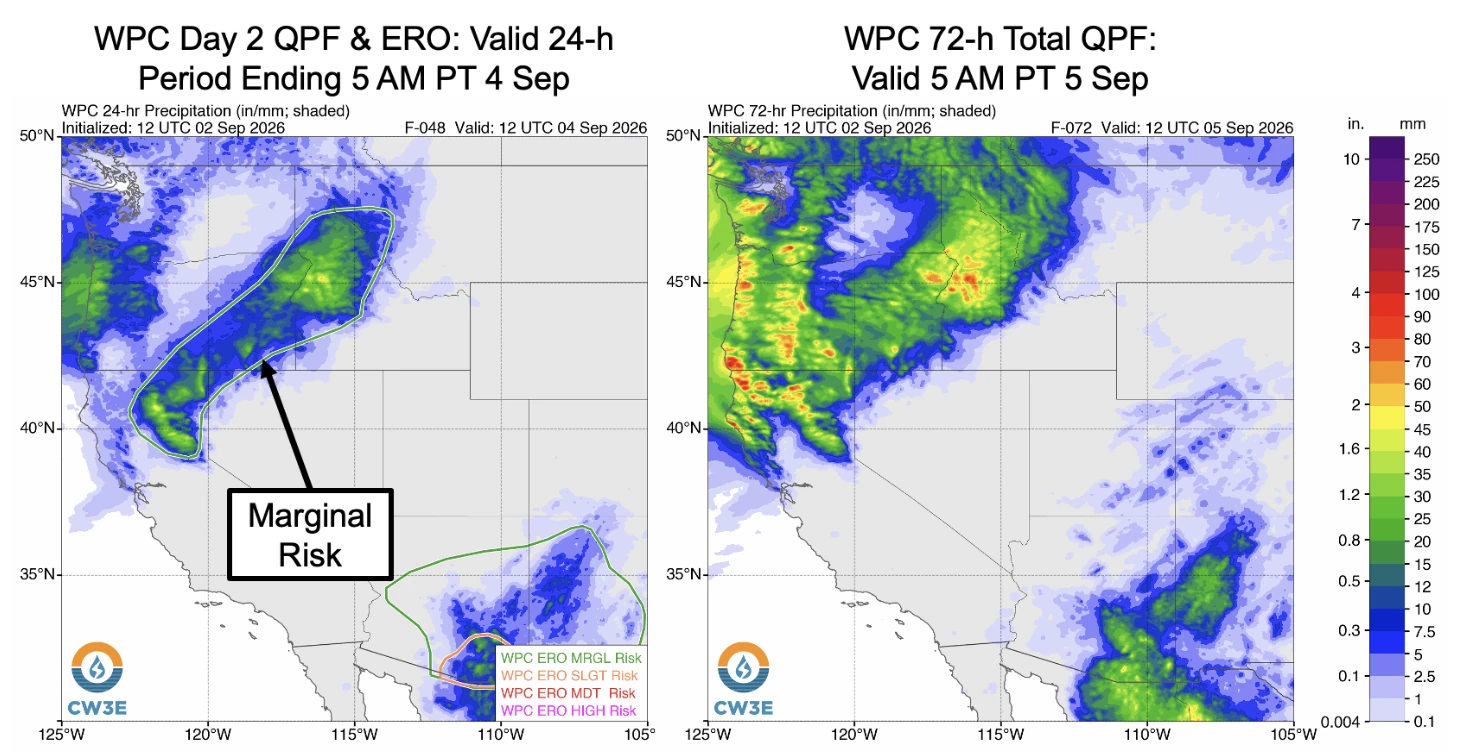
WPC forecast 25–75 mm (1–3 inches) of total precipitation over the Coast Ranges, Cascades, northern Sierra Nevada, eastern Oregon and western Idaho through 05:00 PT (12:00 UTC) on Saturday, September 5, with locally higher amounts possible at higher elevations.
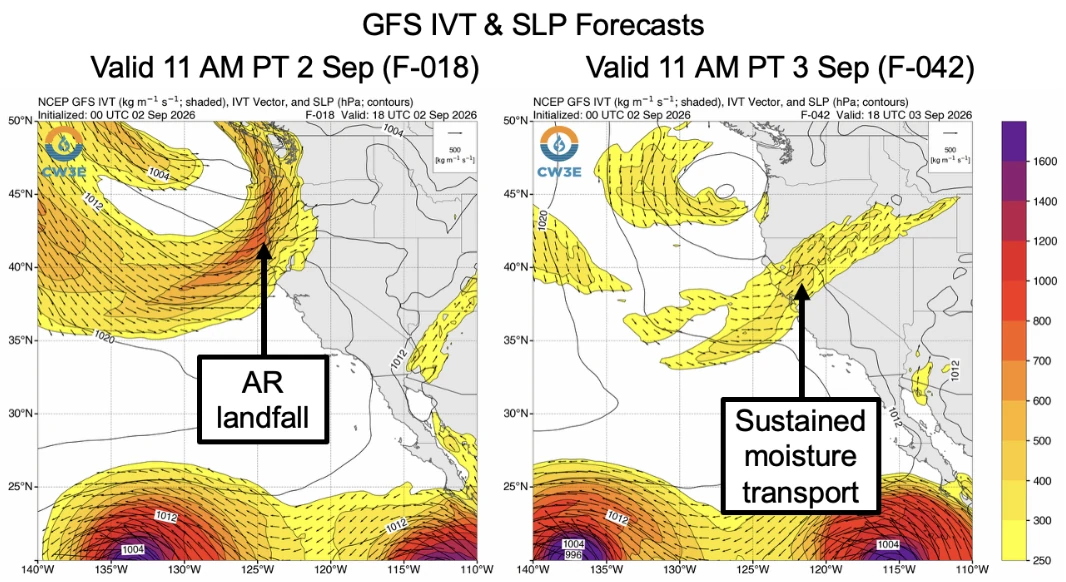
Its Day 2 quantitative precipitation forecast and excessive rainfall outlook covered the 24-hour period ending 05:00 PT (12:00 UTC) on September 4, while the 72-hour total precipitation forecast extended through 05:00 PT (12:00 UTC) on September 5.
Interior northern California, eastern Oregon and western Idaho were under a Marginal Risk, level 1 of 4, for excessive rainfall from 05:00 PT (12:00 UTC) on Thursday, September 3, through 05:00 PT (12:00 UTC) on Friday, September 4.
Farther south, Tropical Storm Marie strengthened into a hurricane at 03:00 UTC on September 3, about 600 km (375 miles) SW of the southern tip of Baja California.
The system is moving toward the west-northwest near 17 km/h (10 mph), and this motion should continue for the next few days. Maximum sustained winds were near 85 mph (140 km/h) at 09:00 UTC today. Some strengthening is forecast during the next 48 hours, and gradual weakening is anticipated to begin by this weekend.
Swells generated by Marie will affect portions of the coast of southwest Mexico and the Baja California Peninsula for the next few days and will likely spread northward to southern California over the weekend. These swells are likely to cause life-threatening surf and rip current conditions.
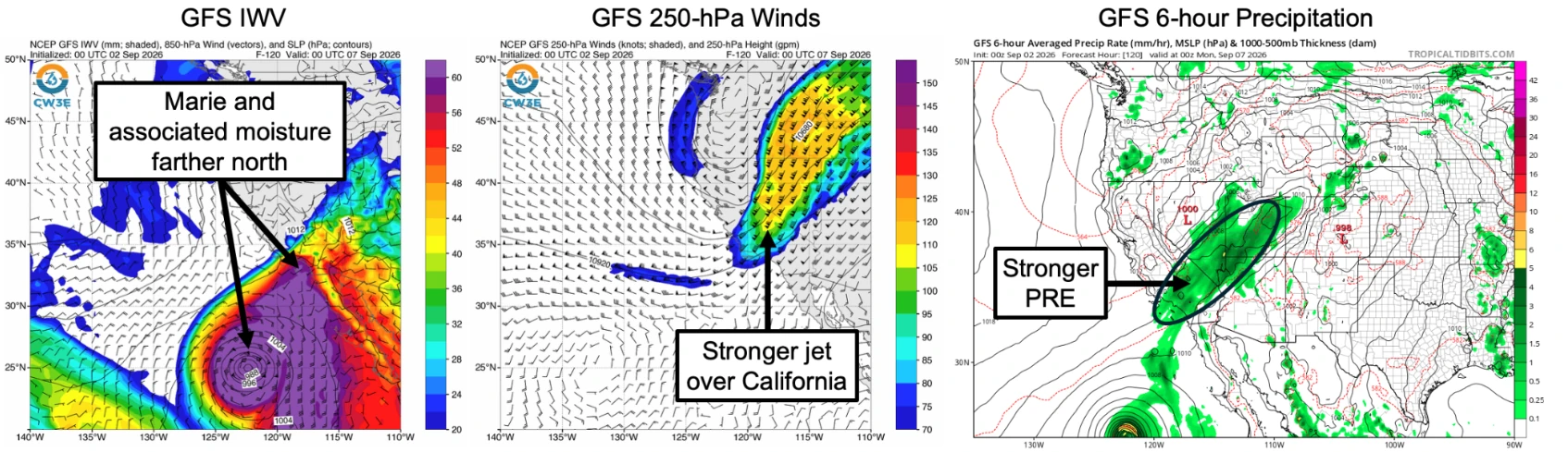
GFS and GEFS still retained the potential for a predecessor rainfall event (PRE) over portions of California and Nevada. In that modeled setup, moisture extending northward from Marie interacts with an upper-level jet streak downstream of an upper-level trough.
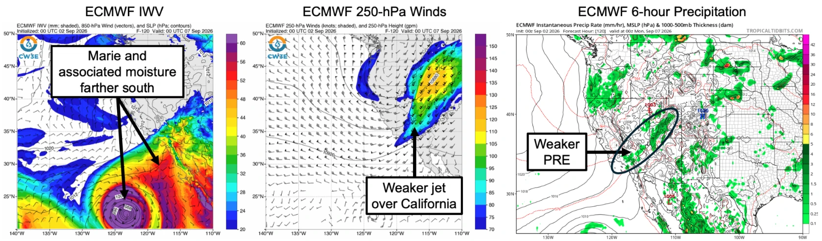
The difference between GFS and ECMWF was clear in forecasts valid at 17:00 PT on September 6 (00:00 UTC on September 7). GFS placed Marie and its associated moisture farther north, with a stronger 250-hPa jet over California and a stronger six-hour PRE precipitation signal.
ECMWF kept Marie and its moisture farther south, showed a weaker upper-level jet over California, and produced a weaker PRE. The Quick Look attributed the lower ECMWF precipitation to weaker phasing between Marie-related moisture and the upper-level features.
Model spread was also evident over the Prado Dam catchment in Southern California, with GFS forecasts showing up to 33 mm (1.3 inches) of mean areal precipitation through 17:00 PT on Monday, September 7, compared with about 7.6 mm (0.3 inches) from ECMWF. GEFS forecast more precipitation than EPS, with approximately 25% of GEFS members exceeding 25 mm (1 inch) during the same period.
The 10-day Prado Dam panel listed 32.3 mm (1.27 inches) from GFS and a GEFS mean of 29 mm (1.14 inches), compared with 6.9 mm (0.27 inches) from ECMWF and an EPS mean of 12.2 mm (0.48 inches). WWRF 9-km guidance listed 16.8 mm (0.66 inches) using GFS and 4.3 mm (0.17 inches) using ECMWF.
WPC also issued a Marginal Risk excessive rainfall outlook for a broad section of the southwestern United States, including the southern third of California, from 05:00 PT (12:00 UTC) on Sunday, September 6, through 05:00 PT (12:00 UTC) on Monday, September 7.
References:
1 Quick Look at Potential Impacts from Early-Season Storm and Marie – CW3E – September 2, 2026

Rishav Kothari is Editor-in-Chief of The Watchers, where he runs the newsroom and covers earthquakes, volcanoes, severe weather and space weather.
