
Typhoon Saudel rapidly intensifies, passes close to Agrihan, Northern Mariana Islands
Typhoon Saudel passed close to Agrihan on August 22, 2026, bringing destructive winds, torrential rain, dangerous surf and coastal inundation to the far Northern Mariana Islands. The National Weather Service (NWS) maintained Typhoon Warnings for Agrihan, Pagan and Alamagan and forecast winds of 129–161 km/h (80–100 mph), with gusts reaching 209 km/h (130 mph).

Satellite image of Typhoon Saudel at 11:30 UTC on August 22, 2026
Typhoon Saudel passed close to Agrihan in the Northern Mariana Islands on August 22 after rapidly intensifying, with maximum sustained winds reaching 177 km/h (110 mph). At 19:00 ChST (09:00 UTC), the center was about 48 km (30 miles) northwest of Agrihan, while Typhoon Warnings remained in effect for Alamagan, Pagan, and Agrihan.
The National Weather Service (NWS) placed Saudel’s center about 105 km (65 miles) north-northwest of Pagan and 161 km (100 miles) north-northwest of Alamagan. The typhoon was moving northwest at 16 km/h (10 mph), with typhoon-force winds extending as far as 72 km (45 miles) and tropical-storm-force winds as far as 241 km (150 miles) from the center.
A CNMI Emergency Operations Center bulletin at 20:00 ChST (10:00 UTC) described Saudel as passing over Agrihan, while the later NWS local statement at 20:53 ChST (10:53 UTC) said it had passed close to the island and placed the center just northwest of it.

The most destructive winds and intense rainfall remained concentrated near the center and were likely affecting northern Agrihan waters. Residents of Alamagan, Pagan and Agrihan were instructed to remain in protective shelters or caves until conditions subsided and an all-clear was issued.
West to southwest winds of 130–160 km/h (80–100 mph), with gusts reaching 210 km/h (130 mph), were forecast across the three islands during the next several hours.
Rainfall totals of 200–300 mm (8–12 inches) were forecast across much of the far northern islands by August 23. Localized accumulations exceeding 500 mm (20 inches) were considered possible near the cyclone’s center, potentially over water.
Periods of torrential rain and scattered thunderstorms were expected through the remainder of the night. Conditions were forecast to improve considerably on August 23 as Saudel continued moving away from the Mariana chain.
Coastal inundation and significant erosion were expected as Saudel-generated swells continued striking reefs around the warned islands. Coastal flooding of 0.3–0.9 m (1–3 feet) around Agrihan and Pagan was expected, while life-threatening surf along south- and east-facing exposures was expected to continue into August 23.
Saipan and Tinian were placed under an all-clear by 08:00 ChST on August 22 (22:00 UTC on August 21), while Typhoon Condition I remained in effect for Alamagan, Pagan, and Agrihan.
The ports of Saipan and Tinian reopened to commercial traffic and cargo operations under Port Heavy Weather Condition Whiskey at 06:30 ChST on August 22. The tropical storm threat to the two islands had ended, although hazardous seas and surf continued.
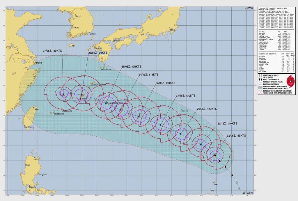
The Joint Typhoon Warning Center (JTWC) assessed Saudel at 176 km/h (109 mph) and 963 hPa based on its 06:00 UTC analysis on August 22. The cyclone strengthened from approximately 111 km/h (69 mph) during the preceding 24 hours, meeting the center’s rapid-intensification classification.
Satellite imagery showed a quickly developing eye approximately 37 km (23 miles) across, with deep convection surrounding most of the center. The analyzed position carried high confidence, while the intensity estimate carried medium confidence.
Environmental conditions remained highly favorable, with sea-surface temperatures of 30–31°C (86–88°F), vertical wind shear of approximately 9–19 km/h (6–12 mph), and strong poleward upper-level outflow. Significant wave height near the cyclone was approximately 10 m (34 feet).
The Japan Meteorological Agency analyzed Saudel at 960 hPa at 09:00 UTC, with 10-minute sustained winds of 144 km/h (90 mph). The lower wind value is the result of the agency’s 10-minute averaging period, compared with the one-minute winds used by JTWC.
JTWC forecast Saudel to reach approximately 240 km/h (150 mph) by 18:00 UTC on August 23 and maintain that intensity through approximately 06:00 UTC on August 24. JMA forecast a minimum pressure near 925 hPa and 10-minute sustained winds of 180 km/h (112 mph) at 06:00 UTC on August 24.
Both agencies forecast a west-northwestward track toward the Ryukyu Islands. JTWC placed Saudel near Okinawa around 06:00 UTC on August 26 with winds of approximately 167 km/h (104 mph), while JMA placed the forecast center near 25.9° N, 127.7° E at the same time.
The Okinawa passage remains a forecast outcome. JTWC assigned high confidence to the track through 72 hours and medium confidence thereafter, with cross-track model spread increasing from approximately 232 km (144 miles) at 72 hours to 315 km (196 miles) later in the forecast period.
Intensity guidance remained divided. Rapid-intensification aids indicated a possible peak of 260–280 km/h (161–173 mph), while other guidance peaked at approximately 195–205 km/h (121–127 mph). The official forecast of 241 km/h (150 mph) was positioned closer to the rapid-intensification guidance.
Across the south-central Marianas, combined seas of 2–3 m (7–10 feet) were forecast through the weekend. Small Craft Advisories remained in effect through the afternoon of August 23, together with hazardous surf and dangerous rip currents along affected reefs.
A separate rainfall threat was developing behind Saudel. NWS said a disturbance northwest of Yap and an associated southwest monsoon surge would support locally heavy rain from Guam northward to Rota during the following 72 hours.
A Hydrologic Outlook also forecast 100–180 mm (4–7 inches) of rain across Guam, Rota, Tinian, and Saipan beginning August 25, with increasing flooding and mudslide potential associated with a potential new disturbance.
References:
1 Typhoon Saudel Advisory Number 16 – NWS – August 22, 2026
2 Tropical Cyclone Local Statement – NWS – August 22, 2026
3 Prognostic reasoning for Typhoon 17 W (Saudel) Warning NR. 16- JTWC – August 22, 2026 at 09:00 UTC; analysis valid at 06:00 UTC

Rishav Kothari is Editor-in-Chief of The Watchers, where he runs the newsroom and covers earthquakes, volcanoes, severe weather and space weather.
Published in the last 24 hours
- Bay of Bengal system to become Cyclone Akvan, landfall forecast between Nellore and Tuni on November 20, India
- Tropical Cyclone Xavier reaches Category 2 over Northern Cook Islands, gale warning for Manihiki and Rakahanga
- El Niño floods kill 2 in Guayaquil as 172.8 mm of rain swamps Milagro, Ecuador's toll rises to 14
- Southern Thailand braces for heavy rain, 15 provinces on flood and landslide alert for November 18-22
