
Enhanced Risk of severe thunderstorms from northern Illinois into the Ohio Valley
The Storm Prediction Center (SPC) has issued an Enhanced Risk of severe thunderstorms from northern Illinois into the Ohio Valley for August 11, 2026, with damaging winds as the primary threat. A potentially organized mesoscale convective system moving southeast from Iowa could produce a swath of damaging gusts, including some above 120 km/h (75 mph), if it remains well organized.
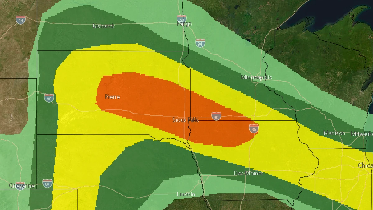
Image credit: NWS/SPC
The Storm Prediction Center (SPC) issued an Enhanced Risk of severe thunderstorms from northern Illinois into the Ohio Valley for August 11.
Damaging winds will be the main threat. A potentially organized mesoscale convective system moving southeast from Iowa could produce a long swath of damaging winds, with some gusts above 120 km/h (75 mph), if the system remains well organized.
The Enhanced Risk area covers northern Illinois into the Ohio Valley. A broader Slight Risk extends across parts of the Northern Plains and from Iowa eastward to Virginia.

SPC forecasters described a complex convective scenario from Iowa into the Ohio Valley and adjacent Appalachians, with more than one mesoscale convective system potentially present near the beginning of the forecast period.
One system is expected in the Iowa and southern Minnesota area, while separate convection could be present farther southeast, most probably across Indiana or Ohio.
If early-day convection develops across Indiana and Ohio, the SPC expects it to spread east and southeast through the Ohio Valley with a risk of strong wind gusts.
The activity is then likely to emerge across the Appalachians and later Virginia and the broader Mid-Atlantic during the afternoon and evening.
The extent of downstream destabilization remains uncertain because of convection from the previous day and possible convective debris across the region; damaging-wind potential there depends on sufficient afternoon destabilization.
The anticipated MCS across Iowa and southern Minnesota early in the period is forecast to move east and southeast through the Midwest over a very moist and strongly unstable boundary layer. The mid-level flow is also strong by August standards, with forecast guidance showing 700 mb winds above approximately 110 km/h (70 mph) spreading across the Midwest through the evening.

The exact evolution of the Midwest MCS remains uncertain. If the morning convection over Iowa develops southeastward along its outflow and maintains a well-organized structure into the Ohio Valley, the combination of strong wind fields and instability would support a swath of damaging gusts, with some potentially exceeding 120 km/h (75 mph).
A separate severe-weather corridor is forecast across the Northern Plains, where east to southeasterly surface flow is expected to maintain dewpoints around 16–21°C (60s°F) across the western Dakotas and parts of Nebraska. Steep mid-level lapse rates above the relatively moist boundary layer, combined with strong daytime heating, are forecast to support moderate to strong instability across the western Dakotas.
Scattered thunderstorms are forecast to develop by early evening in an environment favorable for supercells. Elongated hodographs support splitting cells with an accompanying risk of large to very large hail, while isolated severe wind gusts are also possible. The SPC expects convection to weaken with eastward extent overnight because a stronger nighttime low-level jet is not forecast to develop.
References:
1 Day 1 Convective Outlook – NOAA/SPC – August 11, 2026

I am an Assistant Editor and Severe Weather & Science Journalist at The Watchers, specializing in real-time severe weather coverage, geophysical event reporting, and research-driven scientific analysis. You can reach me at rishav(at)watchers(.)news.

Commenting rules and guidelines
We value the thoughts and opinions of our readers and welcome healthy discussions on our website. In order to maintain a respectful and positive community, we ask that all commenters follow these rules.